
2010 Summer SEPA Road Meet Group Photo

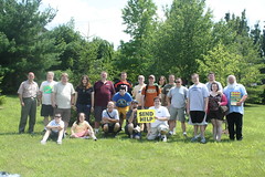
Last Saturday, June 19, 2010, Jeff Kitsko held the 2010 Summer Southeastern PA Road Enthusiasts Meet. The meet was held at the SlyFox Brewery in Pheonixville, PA.

Jeff then lead a tour of the northern and western suburbs of Philadelphia and some of the road projects going on there. Maggie (who took the photo) and I only attended the lunch. so hopefully Doug or other folks from the blog (ahem ahem) will post the meet tour photos soon!

Comments

Popular posts from this blog

The Pollasky Bridge

The Pollasky Bridge near modern day Friant is a ruined highway bridge which was completed during early 1906 as part of the Fresno-Fresno Flats Road.  The structure is one of the oldest known arch concrete spans to have been constructed in California.  The bridge briefly carried California State Route 41 following the destruction of the Lanes Bridge in 1940.  The Pollasky Bridge itself was destroyed by flooding during 1951, but the ruins can still be found on the Madera County side of the San Joaquin River.   Pictured as the blog cover is the Pollasky Bridge as it was featured in the 1913 book "The Concrete Bridge."  The structure can be seen crossing the San Joaquin River near Friant below on the 1922 United States Geological Survey Map.   Part 1; the history of the Pollasky Bridge The Pollasky Bridge site is near modern day Friant of Fresno County.  The community of Friant was established as Converse Ferry during 1852 on the San Joaquin Rive...

Trimmer Springs Road (Fresno County)

Trimmer Springs Road is an approximately forty-mile rural highway located in Fresno County.  The corridor begins near in California State Route 180 in Centerville and extends to Blackrock Road at the Kings River in the Sierra Nevada range near the Pacific Gas & Electric Company town of Balch Camp. The roadway is named after the former Trimmer Springs Resort and was originally constructed to facilitate access to the Sanger Log Flume.  Trimmer Springs Road was heavily modified and elongated after construction of Pine Flat Dam broke ground in 1947.   Part 1; the history of Trimmer Springs Road Much of the original alignment of Trimmer Springs Road was constructed to facilitate access to the Sanger Log Flume.   The  Kings River Lumber Company  had been established in 1888 in the form of a 30,000-acre purchase of forest lands in Converse Basin.  This purchase lied immediately west of Grant Grove and came to be known as "Millwood."  The co...

When was Ventura Avenue east of downtown Fresno renamed to Kings Canyon Road? (California State Route 180)

California State Route 180 was one of the original Sign State Routes designated in August 1934.  The highway east of Fresno originally utilized what was Ventura Avenue and Dunlap Road to reach what was then General Grant National Park.  By late year 1939 the highway was extended through the Kings River Canyon to Cedar Grove.   In 1940 General Grant National Park would be expanded and rebranded as Kings Canyon National Park.  The Kings Canyon Road designation first appeared in publications circa 1941 when the California State Route 180 bypass of Dunlap was completed.  Kings Canyon Road ultimately would replace the designation of Dunlap Road from Dunlap to Centerville and Ventura Avenue west to 1st Street in Fresno.   The Kings Canyon Road would remain largely intact until March 2023 when the Fresno Council designated Cesar Chavez Boulevard.  Cesar Chavez Boulevard was designated over a ten-mile corridor over what was Kings Canyon Road, remaini...