
Sign finds in Durham

While running errands today, I took my camera with me out to Durham County to get photos of a set of older signs.  One sign has been known for sometime, the other I just discovered in the last month.

First, a number of years ago, NCDOT widened and improved Interstate 85 in Durham.  As part of that all of the signage was upgraded.  Well it looks like there was at least one exception - this older Junction I-85, US 15, and US 70 combination still stands on NC 55.

100_0002

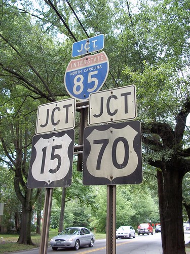
I had found that combination by happenstance a few weeks ago.

Also, on NC 147, the Durham Freeway, it is well known that what is most likely the only metric sign in North Carolina stands.

100_0003

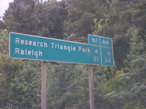
NCDOT is in the process of upgrading a lot of the signage on the Durham Freeway, and I wanted to make sure I grabbed a shot of it in case the sign finds the chopping block this go around.

So I guess you can still find a few sign treats in North Carolina - if you look hard enough.

Comments

Popular posts from this blog

Old US Route 60/70 through Hell (Chuckwall Valley Road and Ragsdale Road)

Back in 2016 I explored some of the derelict roadways of the Sonoran Desert of Riverside County which were part of US Route 60/70; Chuckwalla Valley Road and Ragsdale Road. US 60 and US 70 were not part of the original run of US Routes in California.  According to USends.com US 60 was extended into California by 1932.  US 60 doesn't appear on the California State Highway Map until the 1934 edition. USends.com on US 60 endpoints 1934 State Highway Map Conversely US 70 was extended into California by 1934, it first appears on the 1936 State Highway Map. USends.com on US 70 endpoints 1936 State Highway Map When US 60 and US 70 were extended into California they both utilized what was Legislative Route Number 64 from the Arizona State Line west to Coachella Valley.  LRN 64 was part of the 1919 Third State Highway Bond Act routes.  The original definition of LRN 64 routed between Mecca in Blythe and wasn't extended to the Arizona State Line until 1931 acc...

Trimmer Springs Road (Fresno County)

Trimmer Springs Road is an approximately forty-mile rural highway located in Fresno County.  The corridor begins near in California State Route 180 in Centerville and extends to Blackrock Road at the Kings River in the Sierra Nevada range near the Pacific Gas & Electric Company town of Balch Camp. The roadway is named after the former Trimmer Springs Resort and was originally constructed to facilitate access to the Sanger Log Flume.  Trimmer Springs Road was heavily modified and elongated after construction of Pine Flat Dam broke ground in 1947.   Part 1; the history of Trimmer Springs Road Much of the original alignment of Trimmer Springs Road was constructed to facilitate access to the Sanger Log Flume.   The  Kings River Lumber Company  had been established in 1888 in the form of a 30,000-acre purchase of forest lands in Converse Basin.  This purchase lied immediately west of Grant Grove and came to be known as "Millwood."  The co...

When was Ventura Avenue east of downtown Fresno renamed to Kings Canyon Road? (California State Route 180)

California State Route 180 was one of the original Sign State Routes designated in August 1934.  The highway east of Fresno originally utilized what was Ventura Avenue and Dunlap Road to reach what was then General Grant National Park.  By late year 1939 the highway was extended through the Kings River Canyon to Cedar Grove.   In 1940 General Grant National Park would be expanded and rebranded as Kings Canyon National Park.  The Kings Canyon Road designation first appeared in publications circa 1941 when the California State Route 180 bypass of Dunlap was completed.  Kings Canyon Road ultimately would replace the designation of Dunlap Road from Dunlap to Centerville and Ventura Avenue west to 1st Street in Fresno.   The Kings Canyon Road would remain largely intact until March 2023 when the Fresno Council designated Cesar Chavez Boulevard.  Cesar Chavez Boulevard was designated over a ten-mile corridor over what was Kings Canyon Road, remaini...