After leaving California State Route 35 I pulled onto Great Highway along the Pacific Coastline on Ocean Beach.

Great Highway is a 3.5 mile stretch of coastal road spanning from CA 35/Skyline Boulevard north to Point Lobos. Great Highway was long planned by the City of San Francisco but was officially opened in 1929. The roadway provides access to the coastline and is actually surprisingly wide despite being heavily eroded.

The view of Great Highway and Ocean Beach in particular looking south are nice.

A link to the 1929 article about the dedication of Great Highway can be found below. Interesting boast that was made about it being the "greatest" stretch of highway ever built.
San Francisco on Great Highway
The section of Great Highway from Skyline Boulevard north Sloat Boulevard (seen in the first photo on this blog) likely won't be around as a through route for much longer. In October the city of San Francisco announced it plans to close this stretch of Great Highway but no time line has been announced.
San Francisco Examiner on Great Highway closure
Point Lobos is part of the larger Lands End section of western San Francisco. Ever since the California Gold Rush when the city of San Francisco went through it's first major population boom the area has been desirable for development along the coastline. The modern Cliff House was constructed back in 1909 and is the third structure at the location.


Apparently Point Lobos Avenue was constructed back in the 1850s as a stage route to the coast. The National Park Service covers both the Point Lobos Cliff Houses and Lands End on NPS.gov.
NPS.gov on Lands End
NPS.gov on the Cliff House
I took El Camino Del Mar up to the north section of Lands End where the Golden Gate Bridge can be seen from Eagles Point.

I followed El Camino Del Mar northward which becomes Lincoln Boulevard. I stopped by Baker Beach for another view of the Golden Gate Bridge.

Continuing northward on Lincoln Boulevard I stopped at the Battery Godfrey Parking lot which a trail head along the coast leading to the Golden Gate Bridge.

Battery Godfrey was apparently constructed in 1905, it has a great view of the Golden Gate and the Marin Headlands to the north.


I actually was doing a bit of trail running so actually getting from Battery Godfrey to Battery Boutelle was a little dicey given it took climbing down a cliff-face. Battery Boutelle was apparently constructed back in 1900.

After passing Battery Marcus Miller and Battery Cranston I passed underneath the Golden Gate Bridge in view of Fort Point. Fort Point was built back in 1853 as was in service by the US Army until 1970. Fort Point was built so that cannonball fire would actually bounce off the waters of the Golden Gate to hit any potential enemy ships attempting to enter San Francisco Bay.


I continued on foot up onto the Golden Gate Bridge itself to get a mid-bridge view of San Francisco Bay. The waters were muddy from all the winter flood waters coming from the Sierras far to the east. Interestingly I found traffic for bikes to be heavily enforced by San Francisco PD but so long as I stayed to the right lane nobody really seemed to care that I was on foot.

I thought the moveable barrier on the Golden Gate Bridge was interesting to see. The actual machine used to move the barriers was on the Marin side of the bridge when I was driving over the following morning.


After back tracking to my car I snaked around the Presidio of San Francisco on Lincoln Boulevard to reach US 101 at the intersection of Lombard Street and Richardson Avenue.

The rest of the day was closed on US 101, Lombard Street, Fisherman's Wharf, Hyde Street Pier, and Municipal Pier in downtown. Since I already talked about the history of the realignment of US 101 over the Golden Bridge and Lombard Street when I returned to San Francisco in November 2017 I'll just link over what I wrote here.
November Bay Area Trip Part 6; Downtown San Francisco
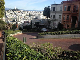
I actually ran up Russian Hill on Lombard Street. I also ran down the curves between Hyde Street and Leavenworth but didn't find out that you aren't supposed walk on the roadway until I saw a sign at the bottom.


Had a nice view of Alcatraz, the Golden Gate Bridge, the Hyde Street Pier, and downtown from Municipal Pier.


There was some interesting old structures from Fort Mason which were easily observed along Van Ness Avenue. The current structures at Fort Mason date back to 1912 but the area was an Army fortification all the way back in 1864.


I closed out the first day of the Disaster Tourism trip taking pictures of US 101 shields while searching for dinner on Van Ness Avenue.


The next morning I got up early and crossed the Golden Gate Bridge via US 101/CA 1 into Marin County.


Of course I got up early enough to get a sunrise view over the city and San Francisco Bay.

After having a look at sunrise I jumped back on US 101/CA 1 and crossed the Robin Williams Tunnel. My next destination after San Francisco was Point Reyes via the Panoramic Highway.


Great Highway is a 3.5 mile stretch of coastal road spanning from CA 35/Skyline Boulevard north to Point Lobos. Great Highway was long planned by the City of San Francisco but was officially opened in 1929. The roadway provides access to the coastline and is actually surprisingly wide despite being heavily eroded.

The view of Great Highway and Ocean Beach in particular looking south are nice.

A link to the 1929 article about the dedication of Great Highway can be found below. Interesting boast that was made about it being the "greatest" stretch of highway ever built.
San Francisco on Great Highway
The section of Great Highway from Skyline Boulevard north Sloat Boulevard (seen in the first photo on this blog) likely won't be around as a through route for much longer. In October the city of San Francisco announced it plans to close this stretch of Great Highway but no time line has been announced.
San Francisco Examiner on Great Highway closure
Point Lobos is part of the larger Lands End section of western San Francisco. Ever since the California Gold Rush when the city of San Francisco went through it's first major population boom the area has been desirable for development along the coastline. The modern Cliff House was constructed back in 1909 and is the third structure at the location.


Apparently Point Lobos Avenue was constructed back in the 1850s as a stage route to the coast. The National Park Service covers both the Point Lobos Cliff Houses and Lands End on NPS.gov.
NPS.gov on Lands End
NPS.gov on the Cliff House
I took El Camino Del Mar up to the north section of Lands End where the Golden Gate Bridge can be seen from Eagles Point.

I followed El Camino Del Mar northward which becomes Lincoln Boulevard. I stopped by Baker Beach for another view of the Golden Gate Bridge.

Continuing northward on Lincoln Boulevard I stopped at the Battery Godfrey Parking lot which a trail head along the coast leading to the Golden Gate Bridge.

Battery Godfrey was apparently constructed in 1905, it has a great view of the Golden Gate and the Marin Headlands to the north.


I actually was doing a bit of trail running so actually getting from Battery Godfrey to Battery Boutelle was a little dicey given it took climbing down a cliff-face. Battery Boutelle was apparently constructed back in 1900.

After passing Battery Marcus Miller and Battery Cranston I passed underneath the Golden Gate Bridge in view of Fort Point. Fort Point was built back in 1853 as was in service by the US Army until 1970. Fort Point was built so that cannonball fire would actually bounce off the waters of the Golden Gate to hit any potential enemy ships attempting to enter San Francisco Bay.


I continued on foot up onto the Golden Gate Bridge itself to get a mid-bridge view of San Francisco Bay. The waters were muddy from all the winter flood waters coming from the Sierras far to the east. Interestingly I found traffic for bikes to be heavily enforced by San Francisco PD but so long as I stayed to the right lane nobody really seemed to care that I was on foot.

I thought the moveable barrier on the Golden Gate Bridge was interesting to see. The actual machine used to move the barriers was on the Marin side of the bridge when I was driving over the following morning.


After back tracking to my car I snaked around the Presidio of San Francisco on Lincoln Boulevard to reach US 101 at the intersection of Lombard Street and Richardson Avenue.

The rest of the day was closed on US 101, Lombard Street, Fisherman's Wharf, Hyde Street Pier, and Municipal Pier in downtown. Since I already talked about the history of the realignment of US 101 over the Golden Bridge and Lombard Street when I returned to San Francisco in November 2017 I'll just link over what I wrote here.
November Bay Area Trip Part 6; Downtown San Francisco
I actually ran up Russian Hill on Lombard Street. I also ran down the curves between Hyde Street and Leavenworth but didn't find out that you aren't supposed walk on the roadway until I saw a sign at the bottom.


Had a nice view of Alcatraz, the Golden Gate Bridge, the Hyde Street Pier, and downtown from Municipal Pier.


There was some interesting old structures from Fort Mason which were easily observed along Van Ness Avenue. The current structures at Fort Mason date back to 1912 but the area was an Army fortification all the way back in 1864.


I closed out the first day of the Disaster Tourism trip taking pictures of US 101 shields while searching for dinner on Van Ness Avenue.


The next morning I got up early and crossed the Golden Gate Bridge via US 101/CA 1 into Marin County.


Of course I got up early enough to get a sunrise view over the city and San Francisco Bay.

After having a look at sunrise I jumped back on US 101/CA 1 and crossed the Robin Williams Tunnel. My next destination after San Francisco was Point Reyes via the Panoramic Highway.


Comments