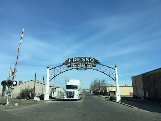
1929 Van Ness Arch; Van Ness Avenue, Fresno California


Recently I decided to re-visit the Van Ness Arch after seeing a Google image of it blocked off by Union Pacific construction.  The Van Ness Arch was located just off of US Route 99/Railroad Avenue at the rail crossing on Van Ness Avenue in southern Fresno.

This blog is part of the larger Gribblenation US Route 99 Page.  For more information pertaining to the other various segments of US Route 99 and it's three-digit child routes check out the link the below.


The Van Ness Arch of Fresno

An archway at Railroad Avenue and Van Ness Avenue was first proposed by the City of Fresno along Legislative Route Number 4 (future US 99) first in 1915.  The original Van Ness Arch was completed in 1917 but only lasted to 1925 when it was damaged by fire.  The current Van Ness Arch dates back to 1929 and features an Arc Deco design.  The 1929 Van Ness Arch states the following greeting: "Fresno, the best little city in the USA, Van Ness Avenue."


Despite the Van Ness Arch being completed only by 1929 the alignment of US 99 shifted to the west off of Railroad Avenue to a wider rail approach into downtown by 1930.  At some point between 1930 the route of Railroad Avenue to the Van Ness Arch may have been signed as a US 99 business route.  Previously I covered the surface route of US 99 in Fresno on the blog below:

Hunting Forgotten History; US Route 99 in Fresno

The fate of the Van Ness Arch is uncertain as access to it will be eventually bisected by the High Speed Rail project.  Said project may also lead to the demolition of former US Route 99 on Railroad Avenue.  Back in 2013 the FresnoBee published a story regarding the history of the Van Ness Arch.

Fresno's Van Ness Avenue welcome arch

Comments

Unknown said…
Don't run the bullet train thru the arch area.This is an historic arch that needs to be preserved.If at all possible,move it a bit north on Van Ness.Once gone,history will be forgotten.

Popular posts from this blog

Former US Route 50 and the Pioneer Route Lincoln Highway on Johnson's Pass Road

Johnson's Pass Road is one of the oldest highway corridors in California.  Johnson's Pass was part of the Lake Tahoe Wagon Road as it was completed during 1856 over the Sierra Nevada.  The pass would later be incorporated into the Pioneer Branch of the Lincoln Highway in 1913 and US Route 50 in 1926.  Johnson's Pass Road would be bypassed by a new alignment of US Route 50 over Echo Summit in 1938.  A replacement of the Meyers Grade east of Johnson's Pass would be opened to traffic in 1947.   Johnson's Pass Road remains accessible to traffic and is still signed by the Lincoln Highway Association.  Pictured as the blog cover is the view from the top of Johnson's Pass Road overlooking modern US Route 50 and Lake Tahoe.   Part 1; the history of Johnson's Pass Much of the history of what become the Lake Tahoe Wagon Road is discussed in the  September 1950 California Highways & Public Works  during its Centennial Edition.  The or...

Former US Route 50 and the South Lincoln Highway from Folsom east to Placerville

The corridor of Folsom of Sacramento County east to Placerville of El Dorado County has been a long established corridor of overland travel dating back to the California Gold Rush.  The Folsom-Placerville corridor was once part of the path of the Lake Tahoe Wagon Road which became the first California State Highway and later the South Lincoln Highway.  In time the South Lincoln Highway's surface alignment was inherited by US Route 50.  The Folsom-Placerville corridor also includes the communities of; Clarksville, Shingle Springs and El Dorado. Part 1; the history of the Lake Tahoe Wagon Road, South Lincoln Highway and US Route 50 through Folsom-Placerville Folsom is located on the American River/Lake Natoma of eastern Sacramento County.  That lands now occupied by the City of Folsom were part of Rancho Rio de los Americanos prior to the finding of gold at Sutter's Mill during 1848.  During the California Gold Rush the lands of Rancho Rio de los Americanos were p...

Abandoned US Route 40 in the Truckee River Canyon

Within the Truckee River Canyon in the Sierra Nevada range numerous abandoned portions of US Route 40 can be found alongside modern Interstate 80.   This segment of highway was opened during 1926 as a bypass of the Dog Valley Grade which carried the early North Lincoln Highway and Victory Highway. The corridor of the Truckee River Canyon State Highway would be assigned as US Route 40 when the US Route System was commissioned during November 1926. During 1958 the segment of Interstate 80 between Boca, California and the Nevada state line was complete. When Interstate 80 opened east of Boca numerous obsolete portions of US Route 40 were abandoned. Some of these abandoned segments have been incorporated into the Tahoe-Pyramid Trail.  Part 1; the history of US Route 40 in the Truckee River Canyon The Truckee River Canyon for centuries has been an established corridor of travel known to native tribes crossing the Sierra Nevada range.  The first documented wagon crossi...