California State Route 225; the Zombie Highway of Santa Barbara and presently shortest in California
This past month I visited the Santa Barbara Area and drove the many short State Highways located there. The shortest and the strangest is the 0.081 mile California State Route 225.

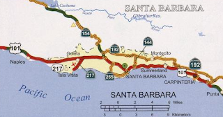
As noted above CA 225 is presently only 0.081 miles in length and is located completely on Castillo Street in Santa Barbara between Montecito Street and US 101/CA 1. Fortunately the Caltrans Post Mile Tool illustrates that CA 225 still exists despite almost being relinquished to death.


At present moment CA 225 is the shortest State Highway in California. By the definition of actual field mileage the following State Highways are the five shortest in California:
1. CA 225 at 0.081 miles
2. CA 275 at 0.14 miles
3. CA 283 at 0.36 miles
4. CA 77 at 0.40 miles
5. CA 153/CA 265 at 0.50 miles each
The origin of CA 225 was back in 1933 when Legislative Route 150 was added to the State Highway system as a loop of US 101/LRN 2 between Santa Barbara east to near Montecito according to CAhighways.org. As originally envisioned LRN 150 ran east from US 101/LRN 2 via; Modoc Avenue, Las Positas Road, Cliff Drive, Montecito Street, Castillo Street and Cabrillo Boulevard. LRN 150 in it's original iteration can be seen on the 1935 California Division of Highways Map of Santa Barbara County.

During the 1964 State Highway Renumbering LRN 150 was assigned as CA 225 which can be seen on the 1964 State Highway Map.

According to CAhighways.org CA 225 was truncated to Castillo Street and US 101/CA 1 in 1998. Whereas CA 225 east previously made a right turn onto Castillo it's new terminus shifted it onto a left hand turn to US 101/CA 1. This routing can be seen on the 2005 State Highway Map.
In 2011 Legislation was introduced which authorized the relinquishment of all of the remaining CA 225 aside from the Castillo Street Interchange. This legislation was made effective in 2013 when the California Transportation Commission authorized the relinquishment of most of CA 225 to the City of Santa Barbara. It is likely that the Castillo Street interchange was kept as a defacto collateral facility of US 101/CA 1 but it was simply easier just to keep it as part of CA 225 rather than introduce new legislation.
I wanted to get more out of my visit to CA 225 than just a block of Castillo Street. That being the case I decided on the 1998 variant of CA 225 and approached what would have been the start of the highway via US 101/CA 1 south at Exit 100 for Las Positas Road.


CA 225 east would have traversed Las Positas Road south to Cliff Drive.


The junction of Las Positas Road and Cliff Drive is presently configured as a roundabout. CA 225 east would have turned onto eastbound Cliff Drive.


CA 225 would have followed Cliff Drive eastward where it becomes Montecito Street after a downward descent.


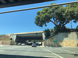
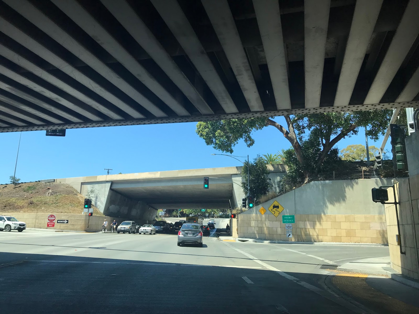
CA 225 east would have originally made a right hand turn from Montecito Street onto Castillo Street. The 1998 variation made a left hand turn onto Castillo Street.

Ironically the present route of CA 225 on Castillo Street wasn't even part of the original variation of LRN 150. CA 225 on Castillo Street is unsigned between Montecito Street and US 101/CA 1. What you see below is what you get with what is left of CA 225.


As noted above CA 225 is presently only 0.081 miles in length and is located completely on Castillo Street in Santa Barbara between Montecito Street and US 101/CA 1. Fortunately the Caltrans Post Mile Tool illustrates that CA 225 still exists despite almost being relinquished to death.


At present moment CA 225 is the shortest State Highway in California. By the definition of actual field mileage the following State Highways are the five shortest in California:
1. CA 225 at 0.081 miles
2. CA 275 at 0.14 miles
3. CA 283 at 0.36 miles
4. CA 77 at 0.40 miles
5. CA 153/CA 265 at 0.50 miles each
The origin of CA 225 was back in 1933 when Legislative Route 150 was added to the State Highway system as a loop of US 101/LRN 2 between Santa Barbara east to near Montecito according to CAhighways.org. As originally envisioned LRN 150 ran east from US 101/LRN 2 via; Modoc Avenue, Las Positas Road, Cliff Drive, Montecito Street, Castillo Street and Cabrillo Boulevard. LRN 150 in it's original iteration can be seen on the 1935 California Division of Highways Map of Santa Barbara County.

During the 1964 State Highway Renumbering LRN 150 was assigned as CA 225 which can be seen on the 1964 State Highway Map.

According to CAhighways.org CA 225 was truncated to Castillo Street and US 101/CA 1 in 1998. Whereas CA 225 east previously made a right turn onto Castillo it's new terminus shifted it onto a left hand turn to US 101/CA 1. This routing can be seen on the 2005 State Highway Map.

In 2011 Legislation was introduced which authorized the relinquishment of all of the remaining CA 225 aside from the Castillo Street Interchange. This legislation was made effective in 2013 when the California Transportation Commission authorized the relinquishment of most of CA 225 to the City of Santa Barbara. It is likely that the Castillo Street interchange was kept as a defacto collateral facility of US 101/CA 1 but it was simply easier just to keep it as part of CA 225 rather than introduce new legislation.
I wanted to get more out of my visit to CA 225 than just a block of Castillo Street. That being the case I decided on the 1998 variant of CA 225 and approached what would have been the start of the highway via US 101/CA 1 south at Exit 100 for Las Positas Road.


CA 225 east would have traversed Las Positas Road south to Cliff Drive.


The junction of Las Positas Road and Cliff Drive is presently configured as a roundabout. CA 225 east would have turned onto eastbound Cliff Drive.


CA 225 would have followed Cliff Drive eastward where it becomes Montecito Street after a downward descent.


CA 225 east would have originally made a right hand turn from Montecito Street onto Castillo Street. The 1998 variation made a left hand turn onto Castillo Street.

Ironically the present route of CA 225 on Castillo Street wasn't even part of the original variation of LRN 150. CA 225 on Castillo Street is unsigned between Montecito Street and US 101/CA 1. What you see below is what you get with what is left of CA 225.


Comments