The Penobscot Narrows Bridge is a 2,120 foot long and 57 foot wide cable stayed bridge that carries US 1 and ME 3 over the Penobscot River in Maine between Verona Island and the town of Prospect. Needing to be a sturdy replacement for the outgoing Waldo-Hancock Bridge, the Penobscot Narrows Bridge opened for travel on December 30, 2006 at a cost of $85 million after just 42 months of planning and construction. The bridge's towers reach 447 feet into the sky and there is a bridge observatory open from May to October. Together with the Penobscot Narrows Bridge Observatory, you can visit Maine's historic Fort Knox. The bridge helps avoid a forty mile detour via Bangor for this major north-south tourist highway, on a coastline that is heavily dependent on summertime visitors, as well as being a major route to nearby Acadia National Park.
The story of the Penobscot Narrows Bridge begins with the former bridge at its location, the Waldo-Hancock Bridge. While the David Steinman designed Waldo-Hancock Bridge was a graceful suspension bridge and served its purpose from 1931 through 2006, due to deteriorating bridge conditions, the bridge was posted from 100,000 pounds down to 24,000 pounds. As a result of this, MaineDOT moved quickly to begin the complex job of building a new bridge. Prior to construction of the Waldo-Hancock Bridge, a ferry regularly carried passengers across the Penobscot River in the Bucksport area. But realizing that automobile traffic along coastal Maine was increasing, in 1929, the Maine legislature authorized $1.2 million in 30 year bonds to construct the Waldo-Hancock Bridge, with the understanding that the cost would be recouped by tolls until the bridge was paid off. The 35 cent toll was charged until October 31, 1953, when the cost of the bridge was repaid by the tolls. What began as a traffic necessity to accommodate the increasing number of northbound travelers on US 1 soon became a historical and economic landmark as well as an example of engineering innovation.
Construction of the Waldo-Hancock bridge began in late summer of 1930 and continued through the winter. Built in record time, the Waldo-Hancock Bridge was opened on November 16, 1931 to much fanfare, providing a vital link between the inland population of Maine and the maritime commerce along the coast. The bridge underwent a rehabilitation beginning in 2000. Then, in 2003, when MaineDOT was partway through a major rehabilitation of the main suspension cables of the 71 year old bridge, engineers discovered the severe corrosion of the cables that had been hidden by protective sheathing. The engineers agreed the cables were too corroded to save and the bridge would need to be replaced as soon as possible. Then they shifted their efforts towards keeping it working safely just long enough to replace it. The Waldo-Hancock Bridge did not face immediate demolition after the Penobscot Narrows Bridge opened, as it sat idly for about six years before it met the wrecking ball in the Fall of 2012. The federal government paid 80 percent of the estimated $7.6 million bridge removal costs with the State of Maine chipping in the remaining 20 percent for the demolition of the old Waldo-Hancock Bridge.
Unlike the Waldo-Hancock Bridge, the Penobscot Narrows Bridge has never been tolled, and plans to build the new bridge came together relatively quickly. Design for the bridge was led by Figg Engineering Group of Florida with engineering and construction led jointly by Cianbro and Reed & Reed. During the planning and design process, the community suggested the new bridge incorporate a granite theme to honor the significance that this stone has had in the local economy. Granite reflects that timeless, rugged, no nonsense nature of Maine and Mainers. In their research, MaineDOT discovered that the Washington Monument was built partially of granite from nearby Mount Waldo. This led to the idea of modeling the main support towers of the new bridge after the obelisk shape of the Washington Monument, and to include an observatory at the top, just like the Washington Monument. At one point, the name of Downeast Gateway Bridge was considered for the name of the new bridge, but the name of the Penobscot Narrows Bridge and Observatory ultimately won unanimous approval from the Maine State Legislature's Transportation Committee as the name of the new bridge linking Prospect and Verona Island.
The new Penobscot Narrows Bridge was built as a cable stayed bridge that requires less cable than a suspension bridge so it was faster to build, while long term care and maintenance on the cable stayed bridge type is easier and less expensive over the long term. Three separate techniques were used in the bridge's construction to ensure cable maintenance and protection, similar to the construction for the Zakim Bridge in Boston, Massachusetts and the Veterans Glass City Skyway in Toledo, Ohio. The bridge cables are sheathed in 16 inch diameter hard-plastic protective tubes. Each steel strand has been coated with an epoxy that fills the spaces inside the strand as well as coating the outside. Each plastic tube is filled with an inert gas that allows the internal pressure to be monitored by computer, which will verify that the pipe is not leaking and eliminates all oxygen from the cable stayed environment. Further, if the tubing should be compromised, the cable will not corrode because the strand is in a nearly oxygen free environment. This design also means that the individual cables can be easily replaced when needed or upgraded without disturbing traffic or compromising bridge safety. The materials used in the bridge construction were massive. Some of the Penobscot Narrows Bridge project details and materials included 20,000 cubic yards of structural earth excavation and 2,700 cubic yards of structural rock were used. Millions of pounds of steel and concrete were used in construction. Forty cable stays were installed, ranging from 283 feet to 1,136 feet in length. Pretty high tech, I may say!
As part of the construction of the Penobscot Narrows Bridge, a feature that is unique to the United States was included. That would be the Penobscot Narrows Bridge Observatory. The observatory opened on May 19, 2007. The bridge has become a visitor destination unto itself, not just to simply carry traffic across the narrows of the Penobscot River. Taller than the Statue of Liberty, no other public bridge observatory currently exists in North America and none reaches higher anywhere else in the world. The observatory towers 420 feet skyward and provides panoramic scenery as far as a hundred miles in all directions, affording great views of nearby Fort Knox, Bucksport and the Penobscot River, along with the surrounding hills and countryside. There are also exhibits on the ground level of the observatory which tell the history of the bridge and the region, along with some fun facts. A combined bridge and observatory is also fairly unusual on a global scale. Similar structures exist in China, Slovakia, Thailand and at the Tower Bridge in London, England, so you would need to go a long distance if you happen to miss this opportunity along the Maine coast. There are multiple parking lots and parking is included with admission to both the bridge observatory and nearby Fort Knox. There is one elevator going up 42 stories to the top of the observatory and the group limit in the elevator is about 8 people. The top of the observatory can comfortably hold about 15 to 20 people. Once at the observation deck area, you have a full 360 view of the area.
 |
| East tower of the Penobscot Narrows Bridge from ground level. |
 |
| East tower again. You can also see one of the bridge piers from the old Waldo-Hancock Bridge, which was just to the north of the Penobscot Narrows Bridge. |
 |
| West bridge tower. If you look up, you can see the bridge observatory. |
 |
| The Penobscot Narrows Bridge as seen from a pulloff on ME 174, which was around where the western abutments of the old Waldo-Hancock Bridge were located. |
 |
| Driving south on US 1 and west of ME 3, approaching the Penobscot Narrows Bridge from Verona Island. |
 |
| Now at the top of the bridge observatory, we can see the Penobscot River, Fort Knox and Bucksport. |
 |
| Closer view of Fort Knox. |
 |
| Looking east at the bridge, US 1 and ME 3. |
 |
| Bucksport again. It looks like a classic New England seaside village from here. |
 |
| Looking up towards the top of the bridge observatory. |
 |
| Bridge section. |
 |
| Old bridge plaque for the Waldo-Hancock Bridge. |
 |
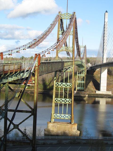
| The Penobscot Narrows Bridge next to the Waldo-Hancock Bridge. The new bridge seems much taller, higher and wider than the old bridge. |
 |
| The Waldo-Hancock Bridge was a graceful bridge, but by the time I took these photos, it was a rusted shell of its former self. |
 |
| Looking at both of the bridges. |
 |
| I used the zoom lens on my camera to get this shot. The Waldo-Hancock Bridge was fenced off and I was able to get the photo through the fence. |
Military fans, history buffs, various tourists and anyone else who enjoys eye popping views will enjoy a visit to Fort Knox State Park, which you can also access when you visit the Penobscot Narrows Bridge Observatory. In fact, when you pay for admission to see the bridge, you are also paying for admission to visit the fort, so if you have time to see both, why not see both the observatory and the fort.
At more than 150 years old, it is Maine’s largest historic fort and one of the best-preserved military fortifications in New England. Located on the west bank of the Penobscot River at the Penobscot Narrows in Prospect, Maine, the fort was named after Major General Henry Knox, America's first Secretary of War, who was born in Boston, but retired to Thomaston, Maine in 1796. Knox's name was also used for the Fort Knox in Kentucky, famous for sitting next to the country’s gold bullion depository. Fort Knox was constructed between 1844 and 1869 to protect the Penobscot River Valley against a possible British naval attack. During the infancy of the United States, Maine was repeatedly involved in northeast border disputes with British Canada. It should be noted that the British had a history of occupying this part of Maine during the Revolutionary War and the War of 1812, which included the construction of a British fort called Fort George, located across the Penobscot Bay in Castine.
The exceptionally well preserved granite fortification is an outstanding example of 19th century engineering. Fort Know was designed by Chief Engineer Joseph Totten with a number of other engineers serving as superintendents of construction from 1844 to 1869, among them Isaac Ingalls Stevens and Thomas L. Casey. The Fort Knox Historic Site includes over 144 acres to explore. The massive and well preserved granite fortification is very impressive, with many unique architectural features. The fort also has a rich and fascinating history, despite the fact that it never saw battle. Soldiers lived and trained at Maine's Fort Knox during the Civil and Spanish American Wars, mostly volunteers undergoing training before being sent to their active posts. During a walk around historic Fort Knox, you will see 10 inch and 15 inch Rodman cannons as well as Howitzer anti-personnel guns, complete with original barrels and carriages, plus there are plenty of passageways and tunnels to explore around the fort. There is certainly a lot to explore at historic Fort Knox.
 |
| Welcome to Fort Knox. |
 |
| I believe those circles would have had guns on them at one time, protecting the fort. |
 |
| Bucksport, Maine across the Penobscot River. |
 |
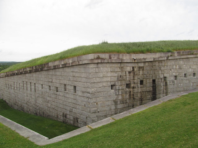
| The walls for the outside of the fort. |
 |
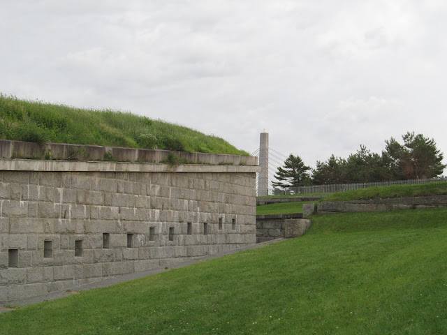
| The Penobscot Narrows Bridge is peeking right now. |
 |
| Checking out the fortifications. |
 |
| I'd like to pick what's behind door number 3. |
 |
| Inside the fort's walls. |
 |
| Munitions and cannons. |
 |
| That's a big gun. |
 |
| The metal pieces on the ground would have been used to move some of the firearms around the fort. |
 |
| A wider view of the inside of Fort Knox. |
 |
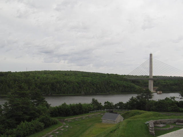
| Fort Knox and Penobscot Narrows Bridge. |
 |
| A parting shot of the Penobscot Narrows Bridge from historic Fort Knox. |
How to Get There:
Sources and Links:
The Historyist - Penobscot Narrows Bridge and Observatory
Maine Department of Transportation - Penobscot Narrows Bridge & Observatory
Maine Department of Transportation - Building a Landmark
Maine Department of Transportation - History of the Former Waldo-Hancock Bridge
Maine Department of Transportation - Discover Fort Knox - Maine's Largest Historic Fort
Cianbro - Penobscot Narrows Bridge & Observatory
Reed & Reed - Penobscot Narrows Bridge
Society of Architectural Historians - Penobscot Narrows Bridge
Bucksport, Maine - Penobscot Narrows Bridge & Observatory
Twelve Mile Circle - Penobscot Narrows Bridge and Observatory
Wine and History Visited - Circus Trip 2018: Penobscot Narrows Bridge
Industrial History - 1939-2013 Waldo-Hancock and 2006 Penobscot Narrows Bridges
Blogging Maine - Penobscot Narrows Bridge and Observatory
Wayfaring Jessica Marie - Penobscot Narrows Bridge, Observatory & Fort Knox Maine Review
Roadside America - Prospect, Maine: Penobscot Narrows Bridge Observatory, Fort Knox Tunnels
Bridgehunter.com - Penobscot Narrows Bridge
Bridgehunter.com - Waldo-Hancock Bridge
WaldoHancockBridge.com - Waldo-Hancock Bridge Replacement Project
Captain Nickels Inn - Explore Fort Knox Maine State Park
Fort Knox Historic Site and Penobscot Narrows Bridge & Observatory - Discover America's Original Fort Knox - Prospect Maine
Bangor Daily News - Demolition of 81-year-old Penobscot River bridge to begin this fall (February 14, 2012)
Bangor Daily News - Demolition of 81-year-old Penobscot River bridge to begin this fall (February 14, 2012)


Comments