Stillwater Covered Bridge - Pennsylvania


The Stillwater Covered Bridge is one of 23 covered bridges found within the borders of Columbia County, Pennsylvania, which is the third largest concentration of covered bridges throughout the Commonwealth of Pennsylvania. Many of these covered bridges are located along Fishing Creek, north of Bloomsburg. This includes the Stillwater Covered Bridge, located in the Borough of Stillwater. Built in 1849 by local settler James McHenry, bridge construction of this 168 foot long covered Burr arch-truss designed bridge cost $1,124 to build. This bridge is now closed to motor traffic, but you can leisurely enjoy your time visiting the bridge or have a picnic inside of the bridge. While you can spot the bridge from PA 487, you can access the bridge through a couple of local streets on the east side of PA 487 in Stillwater.


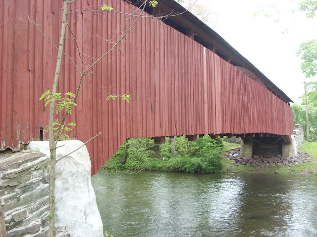
Side profile of the Stillwater Covered Bridge.

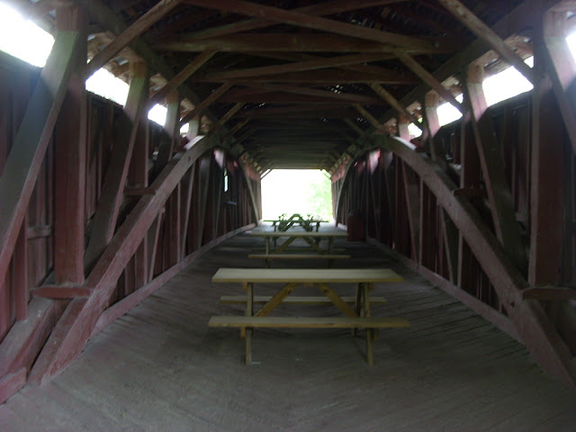
Inside the bridge.

Bridge over Fishing Creek.

Fishing Creek.

Leaving the covered bridge on the narrow Paperdale Road.


How to Get There:


Sources and Links:
Columbia County Covered Bridges - Stillwater Bridge
Bridgehunter.com - Stillwater Covered Bridge 38-19-21


Update Log:
November 20, 2021 - Crossposted to Quintessential Pennsylvania (https://quintessentialpa.blogspot.com/2021/11/stillwater-covered-bridge.html)

Comments

Popular posts from this blog

Interstate 40's Tumultuous Ride Through the Pigeon River Gorge

In the nearly 60 years Interstate 40 has been open to traffic through the Pigeon River Gorge in the mountains of Western North Carolina, it has been troubled by frequent rockslides and damaging flooding, which has seen the over 30-mile stretch through North Carolina and Tennessee closed for months at a time. Most recently, excessive rainfall from Hurricane Helene in September 2024 saw sections of Interstate 40 wash away into a raging Pigeon River. While the physical troubles of Interstate 40 are well known, how I-40 came to be through the area is a tale of its own. Interstate 40 West through Haywood County near mile marker 10. I-40's route through the Pigeon River Gorge dates to local political squabbles in the 1940s and a state highway law written in 1921. A small note appeared in the July 28, 1945, Asheville Times. It read that the North Carolina State Highway Commission had authorized a feasibility study of a "...water-level road down [the] Pigeon River to the Tennessee l...

Massena Center Suspension Bridge

The Massena Center Bridge, also known as the Holton D. Robinson Bridge, has had quite the tumultuous history. Situated on the Grasse River just east of Massena, New York in the hamlet of Massena Center, the Massena Center Bridge is a reminder of the efforts the community has made in order to connect over the river. The first and only other known bridge to be built at Massena Center was built in 1832, but that bridge was never long for this world. During the spring of 1833, the Grasse River dammed itself due to an ice dam, flooded and lifted the bridge off its foundation, destroying the bridge in the process.  The floods were frequent in the river during the spring, often backing up the river from Hogansburg and past Massena Center, but not to nearby Massena. After the first bridge disappeared, local residents had to resort to traveling seven miles west to Massena to cross the next closest bridge, and that was no easy task for a horse and buggy. However, it was many decades befo...

Boca Road Bridge

The Boca Road Bridge is an abandoned wooden deck truss span located on the Truckee River near the former site of Boca siding.  The span was completed in 1926 prior to US Route 40 being built through the Truckee River Canyon.  Boca siding was plotted during the 1860s on the Dutch Flat & Donner Lake Road during the construction of the Central Pacific Railroad.  Boca siding was demolished in portions from the late 1920s through 1939 to make way for the site of Boca Dam.   Part 1; the history of Boca siding and the Boca Road Bridge Boca was founded in 1866 as Central Pacific Camp #17. The site was plotted as a railroad siding and renamed as Boca in 1868. The siding was home to a mill and icehouse which was connected to Truckee via Boca Road (now mostly under the Boca Reservoir). Boca Road is a segment of what was the Dutch Flat & Donner Lake Wagon Road. Said corridor was developed as a frontage of the Central Pacific Railroad during construction of the l...