
The Centennial Corridor and West Side Parkway of California State Route 58


The West Side Parkway and Centennial Corridor are new limited access components of California State Route 58 in the Bakersfield area.  The combined corridors replaced Rosedale Highway with full freeway access from California State Route 99 west to Stockdale Highway.  The combined corridor was first conceived in 1973 by the Kern Council of Governments as part of the 1990 Transportation Plan & Program.  The West Side Parkway would be completed on April 15, 2015, which would be followed by the dedication of the Centennial Corridor on February 9, 2024.  The California Transportation Commission during late 2023 approved continuing to fund potential future projects to extend the West Side Parkway to Interstate 5. 


Part 1; the history of the Centennial Corridor and West Side Parkway

What was to become California State Route 58 west of Bakersfield entered the State Highway System in 1933 as extension of Legislative Route Number 58 (LRN 58).  Specifically, LRN 58 west extended west from US Route 99 (LRN 4) at Golden State Avenue in Bakersfield through the Coast Ranges to US Route 101 (LRN 2) in Santa Margarita.  LRN 58 west of Bakersfield was added as a component of California State Route 178 when the initial run of Sign State Routes was announced in the August 1934 California Highways & Public Works.  


California State Route 178 can be seen departing Bakersfield via 24th Street and Rosedale Highway on the 1938 Division of Highways Map.  


Upon the passage of the 1956 Federal Highway Act on June 29 of said year the Interstate system was created.  The system was based off 41,000 Chargeable Miles which would be managed through the Highway Trust Fund.  The Highway Trust Fund would provide 90% Federal funding for selected Chargeable Interstate corridors.  The Division of Highways attempted to add LRN 58 between proposed Interstate 5 (LRN 238) near Bakersfield east to proposed Interstate 15 (LRN 31) in Barstow, but the corridor was rejected.   

California State Route 178 from US Route 99 in Bakersfield west to planned Interstate 5 (LRN 238) was added to the Freeways & Expressways System in 1959.  Despite the addition there was not a proposed or adopted limited access corridor identified to replace Rosedale Highway.  

As part of the wider 1964 State Highway Renumbering what was California State Route 178 west of Bakersfield was renumbered as California State Route 58.  California State Route 58 initially began multiplexed with California State Route 178 from Golden State Avenue (former US Route 99 re-designated California State Route 24) west on 24th Street to the US Route 99 freeway.  California State Route 178 ended at US Route 99 whereas California State Route 58 continued west on Rosedale Highway towards Interstate 5.  During 1965 US Route 466 (which was already California State Route 58 to Barstow legislatively) would be truncated to Baker and California State Route 58 would be extended as a Sign Route east to Barstow.  

California State Route 58 can be seen in detail in downtown Bakersfield on the 1964 Division of Highways Map.  

The Federal Highway Aid Act of 1968 was signed into law on August 24 of said year.  The Act added an additional 1,500 miles to the Federal Highway Trust fund for Chargeable Interstate mileage.  The Division of Highways applied for California State Route 58 between Interstate 5 east to Interstate 15 in Barstow to be assigned Chargeable Interstate mileage.  The corridor was ultimately rejected for a second time by the Federal Highway Administration.  To date, this is the last attempted act by any agency to add the corridor to the Interstate system.  

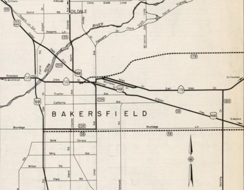
During 1973 the Kern Council of Governments (Kern COG) identified a need for a "Westside Freeway" to replace Rosedale Highway as the alignment of California State Route 58 in their 1990 Transportation Plan & Program.  The California State Route 99 (former US Route 99) and California State Route 58 interchange in Bakersfield was completed in 1976.  California State Route 58 was relocated east of California State Route 99 onto a new freeway grade (Rosa Parks Highway).  North from the new interchange California State Route 58 was multiplexed on northbound California State Route 99 to Rosedale Highway.  From California State Route 99 the routing of California State Route 58 continued west to Interstate 5 along Rosedale Highway. 

The then new freeway alignment of California State Route 58 in eastern Bakersfield can be seen on the 1977 Caltrans Map.  

The existing alignment of California State Route 58 in western Bakersfield persisted with minimal improvements despite being part of the Freeways & Expressway System.  Feasibility studies on transferring California State Route 58 to the proposed Westside Freeway began in 1992 with a Tier 1 Environmental Impact Statement (EIS).  Caltrans and the Federal Highway Administration approved an EIS which had evaluated two proposed alternatives for the proposed Westside Freeway.  

In 2005 now retired Congressman Bill Thomas successfully lobbied for $630 million in Federal funding for Bakersfield area road improvements via the provisions of the Safe, Accountable, Flexible, Efficient Transportation Funding Act (SAFETEA).  The roads covered in the Bakersfield area covered under the provisions of SAFETEA are part of what is known as the Thomas Roads Improvement Program (TRIP).  A current map featuring all of the TRIP projects can be seen below.

2006 Assembly Bill 1858 (Chapter 315) permitted a partial relinquishment of Rosedale Highway in the city of Bakersfield from the State Highway System.  During October 2008 the California Transportation Commission received a notice of preparation of an Environmental Impact Report (EIR) for the conversion California State Route 58 to limited access capacity west of California State Route 99 to Interstate 5.  Numerous project alternatives including a "no build" option were prepared.  Ultimately the 16.61 mile long Alternative B was selected by Caltrans as agency's favored routing for the West Side Parkway.  

Construction of the West Side Parkway would commence in 2009.  During March 2012 the relinquishment authorization enacted in 2006 was acted on.  California State Route 58 along Rosedale Highway between Mohawk Street west to Van Buren Place was subsequently relinquished to local agencies.  The legislative description of California State Route 58 was amended by 2013 Senate Bill 788 (Chapter 525) to reflect the relinquished segment of Rosedale Highway.  

Beginning in 2013 sections of the West Side Parkway would begin to open.  On April 15, 2015, the West Side Parkway was fully opened from Stockdale Highway east to Truxtun Avenue.  The West Side Parkway when initially opened was owned and maintained by the city of Bakersfield.  On December 4, 2015, Caltrans approved the city of Bakersfield's final EIR for the proposed Centennial Corridor.  The Centennial Corridor would provide the final connection of the West Side Parkway from Truxton Avenue east to the California State Route 99/California State Route 58.  The approval of the EIR led to a formal freeway adoption by Caltrans for the Centennial Corridor.  

During 2016 Caltrans began feasibility studies regarding the transfer of the West Side Parkway into the State Highway System.  Caltrans found that the West Side Parkway was in need of remediation to be converted to State Highway standards.  The remediations of the West Side Parkway took place during 2017-2020.  The California Transportation Commission approved the addition of the West Side Parkway from Heath Road east to Coffee Road as the new alignment of California State Route 58 during December 2020.  

Signage of California State Route 58 along Stockdale Highway and West Side Parkway subsequently was erected.  An interim routing of California State Route 58 along Mohawk Street and Rosedale Highway was signed to California State Route 99.  Existing California State Route 58 along Rosedale Highway and Blue Star Memorial Highway west of Van Buren Place west relinquished to Kern County.  

Construction of the Centennial Corridor would commence during 2017 as a multi-phase project.  Phase 1 included improvements to the Kern River Bridge and would be complete by 2020.  The Belle Terrace Operational Improvements of Phase 2 were completed by Spring 2021.  During March 2022 the California State Route 43/California State Route 58/Eons Lane Roundabout was completed.  The Bakersfield Freeway Connector of Phase 3 was completed by summer 2023.  Phase 4 included the Mainline and California State Route 99 Connector Ramps and was completed during February 2024.  

The Centennial Corridor was dedicated on February 9, 2024.  Following the dedication ceremony a cycling event was held on February 10, 2024.  As of the publishing of this blog the Centennial Corridor does not have a formally announced opening date.  The corridor is expected to be open to traffic sometime during February.  

During December 2023 the California Transportation Commission approved future consideration of funding for a limited access extension conversion of California State Route 58 from Interstate 5 east to the current terminus of the West Side Parkway.  The proposed "Interstate 5 Connector" can be seen below on a TRIP map of the West Side Parkway and Centennial Corridor.  


Part 2; the Centennial Corridor dedication ceremony

As noted in Part 1 the dedication ceremony celebrating the completion of the Centennial Corridor was held on February 9, 2024.  The general public was invited to attend the ceremony which included driving over the not yet open Centennial Corridor. 


The dedication began with the National Anthem being performed by the Bakersfield High School Driller Band.  


Opening remarks were given by retired Bakersfield City Manager Alan Tandy.


Bakersfield Mayor Karen Goh provided remarks and presented a key to the city to Bill Thomas.  


Vice Mayor Andrea Gonzales provided commentary regarding benefits of improved commuting access to western Bakersfield provided by the West Side Parkway and Centennial Corridor.  


Executive Director of Kern COG Ahron Hakimi provided commentary on the completion of the Centennial Corridor.  


Caltrans District 6 Director Diana Gomez called for a standing ovation for the Caltrans employees and others who worked on the Centennial Corridor project.  


Commentary was provided by California Transportation Commission Chair Lee Ann Eager. 


Retired Congressman Bill Thomas spoke regarding the upcoming end of TRIP and the history of the program.  


Following the ribbon cutting ceremony at the end of the dedication visitors were permitted to drive through the Centennial Corridor onto California State Route 58. 


Part 3; a drive along the new alignment of California State Route 58 on Stockdale Highway and West Side Parkway

California State Route 58 eastbound now multiplexes Interstate 5 from Exit 257 near Buttonwillow to Exit 253 at Stockdale Highway. 


California State Route 58 eastbound departs Interstate 5 onto Stockdale Highway.  Traffic is advised Bakersfield is 19 miles away.  


California State Route 58 follows Stockdale Highway east to the roundabout at California State Route 43. 


California State Route 58 eastbound enters the West Side Parkway at a traffic light near Stockdale Ranch.  Stockdale Highway transitions away via a right-hand turn.


California State Route 58 passes through the West Side Parkway eastbound towards Truxtun Avenue.  Traffic was required exit onto Truxtun Avenue when the West Side Parkway was fully completed in 2015.  Unnumbered Exits on the West Side Parkway can be found at Allen Road, Calloway Drive, Coffee Road, Mohawk Street and Truxtun Avenue.  The West Side Parkway is officially designated as the Harvey L. Hall Memorial Highway.  


Part 4; a drive along California State Route 58 east through the Centennial Corridor

California State Route 58 east of Truxtun Avenue passes through the Centennial Corridor.  Traffic can access southbound California State Route 99 via Exit 110A or continue east towards Tehachapi via the Rosa Parks Highway.  Strangely Ming Avenue is also signed as being accessible via an Exit Number found on California State Route 99.


Presently there is no interchange movement permitting transitions from eastbound California State Route 58 onto northbound California State Route 99.  Construction of the Centennial Corridor required approximately 200 homes be demolished via the process of eminent domain.  


Part 5; the interim routing of California State Route 58 via Rosedale Highway and Mohawk Street

As noted in Part 1 once Stockdale Highway and West Side Parkway were added to the State Highway System an interim routing of California State Route 58 was needed.  This interim routing followed Rosedale Highway and Mohawk Street from California State Route 99 to West Side Parkway.  


Comments

Popular posts from this blog

Hawaii Route 8930

Hawaii Route 8930 is a 2.5-mile State Highway on the Island of O'hau.  Hawaii Route 8930 is aligned over Kualakai Parkway over the course of its entire alignment south from Interstate H-1 to Kapolei Parkway.  Hawaii Route 8930 is one of the newest Hawaii Routes only having been completed during 2010.   This page is part of the Gribblenation O'ahu Highways page.  All Gribblenation and Roadwaywiz media related to the highway system of O'ahu can be found at the link below: https://www.gribblenation.org/p/gribblenation-oahu-highways-page.html Part 1; the history of Hawaii Route 8930 The history of Hawaii Route 8930 is brief given it is a modern facility.  Hawaii Route 8930 and what was known as "North-South Road" were built to facilitate the developing areas of Kapolei on western O'ahu.  According to hawaiihighways.com the first stage of Hawaii Route 8930 was completed from Kapolei Parkway north to Farrington Highway as a four-lane highway during November...

Madera County Road 607 and the Stockton-Los Angeles Road

Madera County Road 607 is an approximately seven-mile rural unsurfaced highway which spans from Road 600 near Raymond west to Road 29.   Road 607 west from Raymond Road Cemetery (established in 1905) is part of the Stockton-Los Angeles Road corridor surveyed in 1853. The corridor lies in the gap between Fresno Crossing at the Fresno River west to Newton's Crossing at the Chowchilla River. The Buchanan Copper Mine would be along what is now Road 607 in the namesake Buchanan Hollow during July 1863. The Buchanan Mine is thought to have once had a population of between 1,000-1,500 residents by the early 1870s. Copper prices would decline in the decade after the Civil War and much of the activity at Buchanan shifted towards cattle ranching. The last businesses in the community would shutter during World War II and it is now a true ghost town. Part 1; the history of Madera County Road 607 and the Stockton-Los Angeles Road What is now Road 607 was a component of the larger Sto...

Old US Route 60/70 through Hell (Chuckwall Valley Road and Ragsdale Road)

Back in 2016 I explored some of the derelict roadways of the Sonoran Desert of Riverside County which were part of US Route 60/70; Chuckwalla Valley Road and Ragsdale Road. US 60 and US 70 were not part of the original run of US Routes in California.  According to USends.com US 60 was extended into California by 1932.  US 60 doesn't appear on the California State Highway Map until the 1934 edition. USends.com on US 60 endpoints 1934 State Highway Map Conversely US 70 was extended into California by 1934, it first appears on the 1936 State Highway Map. USends.com on US 70 endpoints 1936 State Highway Map When US 60 and US 70 were extended into California they both utilized what was Legislative Route Number 64 from the Arizona State Line west to Coachella Valley.  LRN 64 was part of the 1919 Third State Highway Bond Act routes.  The original definition of LRN 64 routed between Mecca in Blythe and wasn't extended to the Arizona State Line until 1931 acc...