
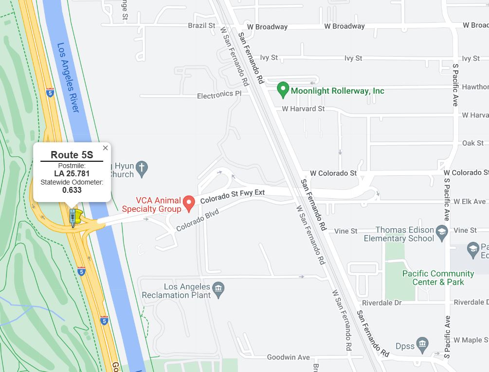
The Colorado Street Freeway Extension is a 0.633-mile spur of mainline Interstate 5. The Colorado Street Freeway Extension connects from Colorado Street in Glendale west to Interstate 5 in Los Angeles via a crossing of the Los Angeles River. The Colorado Street Freeway Extension opened in 1958 as the Golden State Freeway (then US Route 99, US Route 6 and Interstate 5) was being constructed. The Colorado Freeway Extension would serve as a temporary realignment of US Route 99/US Route 6 off of San Fernadno Road and new alignment of California State Route 134. US Route 99 and US Route 6 followed the Colorado Street Freeway Extension to San Fernando Road until the Golden State Freeway was completed to the San Bernadino Freeway in 1962. The Colorado Street Freeway Extension would be assigned as part of the original California State Route 163 as part of the 1964 State Highway Renumbering but was quickly folded into California State Route 134 Spur by 1965. The corridor would be assigned as part of Interstate 5 Spur when the Ventura Freeway extension reached California State Route 2 (then at Verdugo Road) in 1969. 

Part 1; the history of the Colorado Street Freeway ExtensionAs originally configured, Colorado Street ended at San Fernadno Road (US Route 99 and Legislative Route Number 4) in the city Glendale. Colorado Street would become a component of Legislative Route Number 161 (LRN 161) in 1933 after the state began to allow the Division of Highways to maintain State Highways in incorporated cities. The original definition of LRN 161 was as follows:
1. LRN 2 (US Route 101) near Cahuenga Park to LRN 4 (US Route 99) near Burbank
2. LRN 4 (US Route 99) near Glendale to LRN 9 (US Route 66) near Monrovia
The August 1934 California Highways & Public Works announced the initial run of Sign State Routes. California State Route 134 was defined as running concurrent to the entirety of LRN 161. California State Route 134 westbound followed a multiplex of US Route 99/LRN 4 on San Fernando Road from the end of Colorado Street in Glendale to Alameda Avenue in Burbank.
California State Route 134/LRN 161 can be seen following Colorado Street to US Route 99/LRN 4 at San Fernando Road in Glendale on the 1935 Division of Highways Map of Los Angeles. US Route 99 along San Fernadno Road would be joined by an extended US Route 6 beginning in 1937.


The
September/October 1955 California Highways & Public Works cites the Golden State Freeway corridor between the Santa Ana Freeway and Hollywood Freeway as being a recommended for construction and rerouting of US Route 99/US Route 6/LRN 4 by the Los Angeles Chamber of Commerce. The corridor of the Golden State Freeway between the Santa Ana Freeway north to the Hollywood Freeway would take it through the cities of Glendale and Burbank.


The
January/February 1956 California Highways & Public Works notes construction of the Golden State Freeway was underway at Los Feliz Boulevard in Los Angeles and was expected to be completed during summer of 1956. A second project to grade the Golden State Freeway 4.2 miles through Los Angeles, Glendale and Burbank from 0.9 miles south of the Los Angeles River north to Ash Avenue in Burbank was under way.
On June 29, 1956, the Federal Highway Aid Act of 1956 was signed into law on the Federal Level. The Federal Highway Aid Act of 1956 was the genesis point of the Interstate Highway System in California. The Golden State Freeway was destined become part of Interstate 5.
The planned scope of the Golden State Freeway between San Fernadno south to the San Bernardino Freeway appears in the
September/October 1956 California Highways & Public Works. The Colorado Street Freeway Extension is displayed as a component of the wider Golden State Freeway corridor.


The
September/October 1957 California Highways & Public Works features the opening of the Golden State Freeway between the Los Angeles River near Griffith Park north to Ash Avenue. The Los Angeles River-Ash Avenue corridor of the Golden State Freeway opened as realignment of US Route 99/US Route 6/LRN 4 on September 6, 1957.


The Los Feliz Boulevard Interchange and Colorado Street Freeway Extension Interchange of the Golden State Freeway appear in the
January/February 1958 California Highways & Public Works. The Colorado Boulevard Interchange would serve to connect California State Route 134 via LRN 4 to US Route 99/US Route 6 on the Golden State Freeway over the Los Angeles River extending it from San Fernando Road in Glendale. The Los Feliz Boulevard Interchange is stated to still be under construction.

The Golden State Freeway appears complete Alameda Avenue in Burbank south to Glendale Boulevard in Los Angeles on the
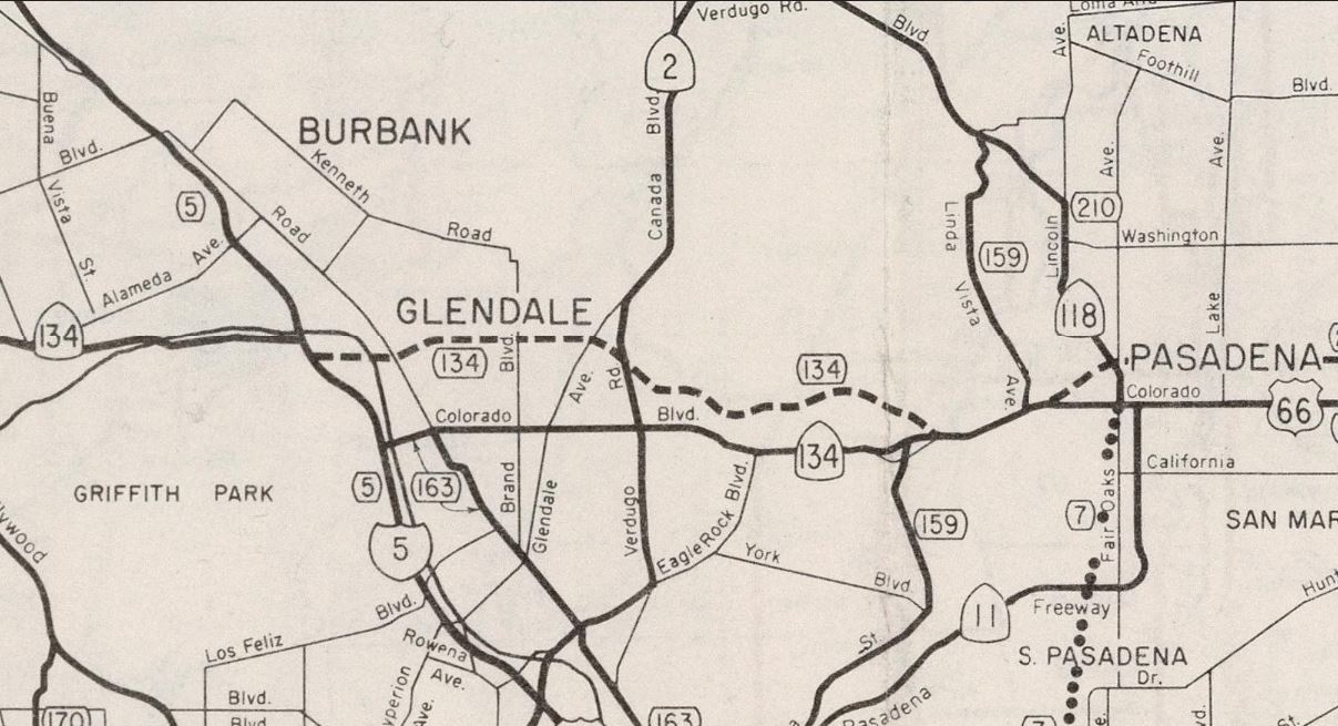
1959 Division of Highways Map. US Route 99/US Route 6 is shown following an interim alignment on LRN 4 originating at San Fernando Road in Burbank, west on Alameda Avenue, south on the Golden State Freeway and east on the Colorado Street Freeway Extension to San Fernando Road in Glendale. California State Route 134 is shown following an interim multiplex of US Route 99/US Route 6/LRN 4 on the Golden State Freeway between Colorado Street north to Alameda Avenue. South of Colorado Boulevard to Glendale Street the Golden State Freeway is shown to be part of LRN 161.
The
September/October 1962 California Highways & Public Works announced the Golden State Freeway was fully complete from Lankershim Boulevard south to the Santa Ana Freeway. The Golden State Freeway from Glendale Boulevard south to Arnold Street is stated to have opened during January 1962 whereas the segment south to Pasadena Avenue opened during March 1962. The completion of the Golden State Freeway from Lankershim Boulevard to the Santa Freeway would see US Route 99 realigned. US Route 99 now followed Interstate 5/LRN 4 on the Golden State Freeway directly to the San Bernardino Freeway bypassing the Pasadena Freeway and Santa Ana Freeway through downtown Los Angeles.


US Route 99 can be seen following the Golden State Freeway and Interstate 5/LRN 4 on a bypass of downtown Los Angeles on the
1963 Division of Highways Map. US Route 6 is displayed following the Golden State Freeway to the Arroyo Seco Parkway. The Colorado Street Freeway Extension is shown as a spur of LRN 4 and solely signed as California State Route 134.

As part of the 1964 State Highway Renumbering the Colorado Street Freeway Extension was assigned as the original iteration of
California State Route 163. The original California State Route 163 was defined as "Near Lacy Street and Avenue 26 to 5." California State Route 163 appears for the first time on the 1964 Division of Highways Map. The Colorado Street Freeway Extension is shown as part of the interim Sign Route routing for California State Route 134. Much of the original California State Route 163 was compromised portions of former US Route 99/US Route 6 along San Fernadno Road south of Colorado Street.
1965 Legislative Chapter 1372 deleted the original California State Route 163 and relinquished San Fernadno Road south of Colorado Street. The Colorado Street Freeway Extension was added California State Route 134 as "California State Route 134 Spur."
During 1969 the Ventura Freeway Extension was completed from Interstate 5 east to California State Route 2 at Verdugo Road. California State Route 134 was rerouted off of Colorado Street in downtown Glendale north on California State Route 2/Verdugo Road to the new segment of the Ventura Freeway. The Colorado Street Freeway Extension was subsequently reassigned as "Interstate 5 Spur." The interim routing of California State Route 134 on Verdugo Road can be seen on the
1970 Division of Highways Map.
Note, Caltrans recognizes all categories of their highway inventory as "State Routes." To that end Interstate 5S is not considered part of the Interstate System by the Federal Highway Administration and does not appear in their mileage calculations for Interstate 5.
Part 2; a drive on the Colorado Street Freeway Extension
Traffic on westbound Colorado Street in Glendale can access the Colorado Street Freeway Extension approaching Kenilworth Avenue.
The Colorado Street Freeway Extension in Glendale is signed as though it was a mainline component of Interstate 5.
The Colorado Street Freeway Extension crosses under San Fernadno Road and enters the city of Los Angeles. The overpass structure at San Fernadno Road still displays a placard for California State Route 134.
The westbound Colorado Street Freeway Extension passes an unnumbered exit to Edenhurst Avenue.
The Colorado Street Freeway Extension crosses the Los Angeles River and terminates at Interstate 5.


Comments