The Blue Ridge Parkway - Mile 316.4 - Linville Falls Spur


One of the more accessible and popular locations along the Blue Ridge Parkway is Linville Falls.  A spur road off the Parkway at mile 316.4 takes you to magnificent waterfalls with multiple vantage points.  It is easy to spend many hours hiking and exploring here.

Linville Falls is the dramatic start to the Linville Gorge - a 13-mile and 1,500- to 2,000-foot-deep natural wonder in North Carolina's mountains. 

The Spur Road leads to a parking area for the falls with numerous hiking trails. There is a visitor's center that is open seasonally.

Map of the Linville Falls Area and hiking trails. (National Park Service)

Two main trails provide access to the falls. The Linville Gorge Trail (1.4 miles round trip) follows the east side of the river and leads to the base of the falls and the Plunge Basin Overlook.  The Erwin's View Trail (1.6 miles round trip) runs along the west side, leading to four different viewpoints - the Upper Falls, Chimney View, Gorge View, and Erwin's View.  The Linville Gorge Trail is the more strenuous of the two.

On this visit, I explored the Erwins View Trail.

Upper Falls:


The first and typically most crowded viewpoint is of the twin 12-foot Upper Falls and the chute that the Linville River flows through before its more dramatic lower falls.

Chimney View:


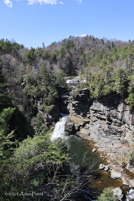
It is a little over 1/4 mile from the Upper Falls to Chimney View.  This location affords opportunities to view and photograph the lower falls in isolation.  

Gorge View:


From Chimney View - an uphill climb leads you to two different vantage points.  The furthest - via the right fork - is Gorge View. While this vantage point does not showcase Linville Falls, it presents a great view of Linville Gorge and spectacular birdwatching.

Erwins View:


Take the Left Fork near the end of the trail - and it leads to one of the most spectacular waterfall viewpoints in the Carolinas, Erwins View.  From here, the entire landscape unfolds before you - the falls, the beginnings of Linville Gorge, the surrounding mountains, and more.


Other Stops along Linville Falls Spur Road:


Dugger's Creek Falls:


When at the Linville Falls Parking Area - don't forget the short and easy trek to Dugger's Creek Falls, which sits near the entrance of the main parking lot.  The loop trail is approximately 1/4-mile long and showcases a small 15' waterfall along Dugger's Creek.

Riverbend Overlook:


There are two Parkway overlooks on the Spur Road, Riverbend and Midway.  The Riverbend Overlook sits along a horseshoe bend of the Linville River, a popular spot for fishing or picnicking.


Navigation:


Sources & Links:

How To Get There:


Comments

Popular posts from this blog

Interstate 40's Tumultuous Ride Through the Pigeon River Gorge

In the nearly 60 years Interstate 40 has been open to traffic through the Pigeon River Gorge in the mountains of Western North Carolina, it has been troubled by frequent rockslides and damaging flooding, which has seen the over 30-mile stretch through North Carolina and Tennessee closed for months at a time. Most recently, excessive rainfall from Hurricane Helene in September 2024 saw sections of Interstate 40 wash away into a raging Pigeon River. While the physical troubles of Interstate 40 are well known, how I-40 came to be through the area is a tale of its own. Interstate 40 West through Haywood County near mile marker 10. I-40's route through the Pigeon River Gorge dates to local political squabbles in the 1940s and a state highway law written in 1921. A small note appeared in the July 28, 1945, Asheville Times. It read that the North Carolina State Highway Commission had authorized a feasibility study of a "...water-level road down [the] Pigeon River to the Tennessee l

Mines Road

Mines Road is an approximately twenty-eight-mile highway located in the rural parts of the Diablo Range east of the San Francisco Bay Area.  Mines Road begins in San Antonio Valley in Santa Clara County and terminates at Tesla Road near Livermore of Alameda County.  The highway essentially is a modern overlay of the 1840s Mexican haul trail up Arroyo Mocho known as La Vereda del Monte.  The modern corridor of Mines Road took shape in the early twentieth century following development of San Antonio Valley amid a magnesite mining boom.  Part 1; the history of Mines Road Modern Mines Road partially overlays the historic corridor used by La Vereda del Monte (Mountain Trail).  La Vereda del Monte was part of a remote overland route through the Diablo Range primarily used to drive cattle from Alta California to Sonora.  The trail was most heavily used during the latter days of Alta California during the 1840s. La Vereda del Monte originated at Point of Timber between modern day Byron and Bre

Interstate 210 the Foothill Freeway

The combined Interstate 210/California State Route 210 corridor of the Foothill Freeway is approximately 85.31-miles.  The Interstate 210/California State Route 210 corridor begins at Interstate 5 at the northern outskirts of Los Angeles and travels east to Interstate 10 in Redlands of San Bernardino County.  Interstate 210 is presently signed on the 44.9-mile segment of the Foothill Freeway between Interstate 5 and California State Route 57.  California State Route 210 makes up the remaining 40.41 miles of the Foothill Freeway east to Interstate 10.  Interstate 210 is still classified by the Federal Highway Administration as existing on what is now signed as California State Route 57 from San Dimas south to Interstate 10.  The focus of this blog will mostly be on the history of Interstate 210 segment of the Foothill Freeway.   Part 1; the history of Interstate 210 and California State Route 210 Interstate 210 (I-210) was approved as a chargeable Interstate during September of