The Central Freeway is a 1.2-mile elevated limited access corridor in the city of San Francisco. As presently configured the Central Freeway connects from the end of the Bayshore Freeway to Market Street. The Central Freeway carries the mainline of northbound US Route 101 from the Bayshore Freeway to Mission Street.
The Central Freeway has origins with the establishment of Legislative Route Number 223 and is heavily tied to the history of the once proposed Panhandle Freeway. The Central Freeway between the Bayshore Freeway and Mission Street was completed during 1955. The corridor was extended to a one-way couplet located at Turk Street and Golden Gate Avenue in 1959 which served to connect US Route 101 to Van Ness Avenue. The Central Freeway was damaged by the 1989 Loma Prieta Earthquake and has since been truncated to Market Street.
The Central Freeway as pictured on the blog cover was featured in the May/June 1959 California Highways & Public Works. The scan below is from the 1960 Division of Highways Map which depicts the then recently completed second segment of the Central Freeway.
Part 1; the history of the Central Freeway
Prior to 1933 the state of California was not permitted to maintain highways within incorporated cities. The city and county of San Francisco would be located on the Auto Trail known as El Camino Real. The Auto Trail name took inspiration from the earlier Spanish overland route of the same name which connected the missions of Spanish held Las Californias. Starting in 1906 the American El Camino Real began to be signed on the highways between San Diego and San Francisco.
The era of State Highway Maintenance on El Camino Real would ultimately begin with the 1909 First State Highway Bond Act which was approved by voters in 1910. One of the highways approved through the 1909 First State Highway Bond Act was a 481.8-mile highway originating at the city limits of San Francisco which terminated in San Diego. This highway would ultimately come to be known in time as Legislative Route Number 2 (LRN 2).
The US Route System would be formally created by AASHO during November 1926 which brought US Route 101 into existence. The routing and maintenance of US Route 101 within San Francisco was initially under city jurisdiction. From Sausalito Point at the terminus of the Redwood Highway (LRN 1), US Route 101 crossed over San Francisco Bay by ferry to Hyde Street Pier. From Hyde Street Pier US Route 101 used the following route through San Francisco:
- South on Hyde Street.
- West on Bay Street.
- South on Van Ness Avenue.
- West on Market Street.
- South on Valencia Street.
- Southwest on Mission Street to Daly City.
A letter from the California State Highway Engineer to the AASHO Executive Committee dated April 16, 1929, submitted the split US Route 101W and US Route 101E in the San Francisco Bay area. US Route 101W was to land from Marin County in San Francisco and followed LRN 2/El Camino Real to San Jose. US Route 101E was to land in Oakland and follow LRN 5 south to San Jose. The request planned to consumed part of US Route 48 between Hayward-San Jose. Likewise, a portion of US Route 48 from Mossdale-French Camp was submitted to be repurposed as US Route 99W.
The AASHO Executive Secretary informed the California State Highway Engineer of the approval for the creation of US Route 101W and US Route 101E on April 20, 1929.


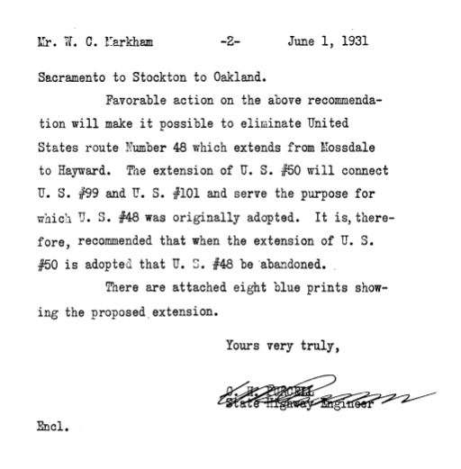
A letter dated June 2, 1931, from the California State Highway Engineer contained an application to the AASHO Executive Commitee to extend US Route 50 to the San Francisco Bay area (via Oakland) and eliminate US Route 48. While not directly stated the request implied the deletion of the East/West branches of US Route 101 in the Bay Area and US Route 99 south of Stockton.
The California State Highway Engineer was informed via telegram on June 12, 1931, that the extension of US Route 50 and elimination of US Route 48 were approved by the Executive Commitee. US Route 101W by proxy reverted to being the singular mainline of US Route 101 in the Bay Area.

In January of 1933 construction of the Golden Gate Bridge began which was followed by the San Francisco-Oakland Bay Bridge in July the same year. The legislative barriers preventing the Division of Highways from maintaining highways in cities was also lifted during 1933. As a result of the bridge construction maintenance of US Route 101 in San Francisco was picked up as an extension of LRN 2 in San Francisco. US Route 101 was realigned through the city from Hyde Street Pier as follows:
- South on Hyde Street.
- West on Bay Street.
- South on Van Ness Avenue.
- East on Fell Street.
- Southeast on 10th Street. US 101W was slated to pick up Bay Bridge traffic via Harrison Street and Bryant Street.
- South on Potrero Avenue.
- South on Bayshore Boulevard
- West on Alemany Boulevard.
- Southwest on San Jose Avenue to Daly City.


In the August 1934 California Highways and Public Works Guide the Sign State Routes were announced. California State Route 1 was applied to LRN 56 from Las Cruces northward towards Fortuna. California State Route 1 was to be aligned with LRN 56 through the City of San Francisco towards Marin County with no implied gaps.
The interim alignment of California State Route 1 is shown in full detail on a 1936 Shell Highway Map of San Francisco and Oakland (clink the 1936 map and pan left from Oakland). California State Route 1 is shown using the following alignment from the San Mateo County Line north to the Hyde Street Pier:
- California State Route 1 northbound enters the city of San Francisco via Junipero Serra Boulevard/LRN 56.
- California State Route 1 merged onto 19th Avenue via the 19th Avenue Extension towards Golden Gate Park on what was part of LRN 56. California State Route 1 intersected California State Route 5 (now California State Route 35) on 19th Avenue at Sloat Boulevard.
- California State Route 1 entered Golden Gate Park via 19th Avenue where state maintenance terminated at Lincoln Way. The highway is shown to traverse the local roads of Gold Gate Park around the western and northern shore of Stow Lake to Fulton Street. The highway is shown to have a planned bypass of Stow Lake which would follow the southern and eastern shores to a planned new alignment via Funston Avenue. The planned Funston Avenue alignment of California State Route 1 is shown traversing the Presidio to the Golden Gate Bridge construction site.
- California State Route 1 is shown heading east via Fulton Street to the City Hall complex at Franklin Street. The highway is shown traversing the City Hall complex via Franklin Street and McAllister Street to reach US Route 101/LRN 2 at Van Ness Avenue.
- California State Route 1 followed a multiplex of US Route 101 via Van Ness Avenue, Bay Street and Hyde Street to the Hyde Street Pier.


A letter dated February 18, 1937, from the California Mission Trails Association to the AASHO Executive Secretary expressed dismay at the recent removal of mainline US Route 101 from El Camino to Bayshore Highway. The view of the association was that the removing mainline US Route 101 from El Camino Real would have a negative impact on the businesses located on LRN 2. The letter requested mainline US Route 101 be restored to El Camino Real and Bayshore Highway instead be assigned as US Route 101 Alternate. The realignment of US Route 101 onto Bayshore Highway shifted it off Alemany Boulevard (LRN 2) in San Francisco.
The AASHO Executive Secretary responded to the California Mission Trails Association on March 2, 1937. In the letter the Executive Secretary explained the US Route System was intended to facilitate Interstate travel and that suffixed routes tended to confuse travelers.
The Golden Gate Bridge was completed April 19th, 1937, and was dedicated on May 28th. The ceremonies leading up to the opening of the Golden Gate Bridge are discussed in the May 1937 California Highways & Public Works. The article notes the unlike the State built San Francisco-Oakland Bay Bridge construction of the Golden Gate Bridge was financed by the six Counties of San Francisco Bay. Thusly even from the outset the Golden Gate Bridge was never considered to be a State Highway facility. The Golden Gate Bridge features an 8,980-foot-long hybrid truss-suspension design. US Route 101/LRN 2 along with California State Route 1 were routed from Hyde Street Pier west from Van Ness Avenue via Lombard Street and Doyle Drive to the Golden Gate Bridge.


The
July 1937 California Highways & Public Works featured the opening of the Bayshore Highway to San Jose. A dedication ceremony was held at the Agnew Underpass on June 12, 1937. This was the last segment of Bayshore Highway to be complete between San Francisco and San Jose.
A letter from the AASHO Executive Secretary dated October 28, 1937, acknowledged the intent of the Division of Highways to sign El Camino Real as US Route 101 Alternate. The concept of moving mainline US Route 101 to Bayshore Highway was first proposed by the Division of Highways during August 1935.
The completed Bayshore Highway is depicted as part of mainline US Route 101 on the
1938 Division of Highways Map. US Route 101 is shown to be realigned onto Bayshore Highway south of Alemany Boulevard in San Francisco.

A letter from the California State Highway Engineer to the AASHO Executive Secretary dated January 10, 1938, explains the local resistance to mainline US Route being removed from El Camino Real. The letter included a publication from Palo Alto which was critical to the shift of mainline US Route 101 to Bayshore Highway.
The El Camino Real Association sent a letter to the AASHO Executive Secretary dated May 20, 1938, suggesting the restoration of mainline US Route 101 to LRN 2. The letter also suggested signing Bayshore Highway as US Route 101 Bypass. Numerous cities along the routings of El Camino Real and Bayshore Highway were noted to be in concurrence with the El Camino Real Association.
The California State Highway Engineer requested an update to the May 28, 1938, AASHO Executive Committee meeting where the restoration of US Route 101 to El Camino Real and proposed US Route 101 Bypass on Bayshore Highway were discussed.
A letter from the AASHO Executive Secretary dated July 27, 1938, acknowledged US Route 101 had been restored to El Camino Real and the establishment of US Route 101 Bypass.
US Route 101 can be seen restored to Alemany Boulevard on the
1940 Division of Highways Map. Bayshore Boulevard south of Alemany Boulevard can be seen as US Route 101 Bypass.

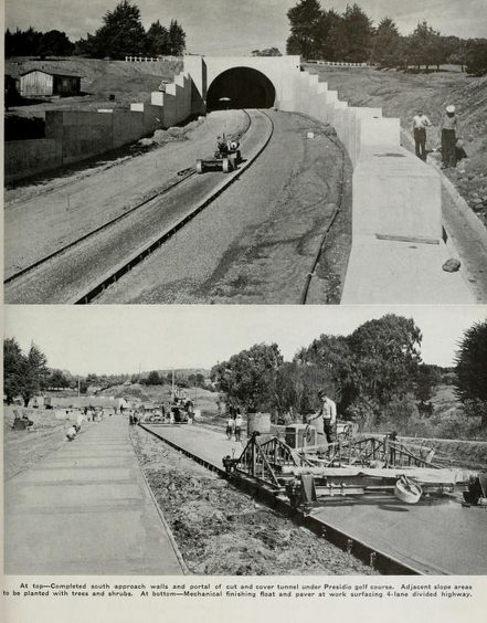
The March 1940 California Highways & Public Works shows the Park-Presidio Boulevard/Funston Avenue Approach of California State Route 1/LRN 56 in ongoing construction. The article cites the Park-Presidio Boulevard Funston Avenue Approach as having an anticipated completion date of April 15th. The 1,300-foot-long tunnel under the Presidio Golf Course is cited as having been completed in January of 1940.
The May 1940 California Highways & Public Works cites the Park-Presidio Boulevard/Funston Avenue Approach along with the 19th Avenue Approach to Golden Gate Park of California State Route 1/LRN 56 as being completed by April 21st. The completed new alignment of California State Route 1 rerouted directly towards the Golden Gate Bridge and removed the multiplex of US Route 101.
The
August 1940 California Highways & Public Works featured the proposed conversion of Bayshore Highway to freeway standards. The freeway conversion was proposed in a California Highway Commission meeting on July 26, 1940. The conversion of Bayshore Highway is cited to be borne out of the explosive population growth patterns in the San Francisco Bay area.
A secondary article in the
same volume details the engineering standards of the proposed Bayshore Freeway.
The beginnings of the Central Freeway being added to the State Highway System came with the addition of
LRN 223 by way of 1947 Legislative Chapter 11. LRN 223 was defined as "a point on LRN 2 near Division Street to LRN 56."
The
1948 Transportation Plan for San Francisco included the concept for the elevated Central Freeway. The Central Freeway as originally planned would branch from the end of the planned Bayshore Freeway along the corridor of Van Ness Boulevard and terminate near the Broadway Tunnel. The Central Freeway was planned to connect with the proposed Panhandle Freeway (also LRN 223) and Mission Freeway.
The
May/June 1950 California Highways & Public Works features construction of the first unit of the Bayshore Freeway in San Francisco. The first unit is shown to be in the process of construction from Augusta Street north to 25th Street. The project is noted to include an interchange with mainline US Route 101/LRN 2 at Alemany Boulevard and was expected to be complete by December.

The
same volume announced a leg of the Central Freeway was submitted as a recommended project during September 1954 California Highway Commission meeting. The article notes the first Central Freeway segment was 0.9 miles long extending from 13th/Mission Street to vicinity of Turk Street. The Central Freeway/Panhandle Freeway combined corridor is noted to be part of LRN 223 and LRN 2. The article depicts the Bayshore Freeway designation as being planned to end at Mission Street.
The
1954 Division of Highways Map depicts the newly completed segment of the Bayshore Freeway to Bryant Street in San Francisco. Mainline US Route 101 is shown relocated from Potrero Avenue onto the new freeway segment to Bryant Street. US Route 101 was carried to 10th Street via the Bryant Street ramp. Part of LRN 223 is shown connecting the extending from the constructed part of the Bayshore Freeway west to Mission Street.
The completed Bayshore Freeway, Central Freeway and San Francisco Skyline interchange was featured on the cover of the
March/April 1955 California Highways & Public Works. US Route 101 transitioned from the northern of the Bayshore Freeway onto the Central Freeway towards Mission Street. The beginning of the San Francisco Skyline carried US Route 40 and US Route 50 towards the Bay Bridge. It isn't fully clear when the Central Freeway designation was extended beyond Mission Street to the Bayshore Freeway/San Francisco Skyway junction.
The J
uly/August 1955 California Highways & Public Works noted the Central Freeway opened from the Bayshore Freeway to Mission Street on March 1, 1955. The Bayshore Freeway is noted to have been opened from Alemany Boulevard to 3rd Street on March 30, 1955. The San Francisco Skyway from the Bayshore Freeway to the Bay Bridge is noted to have opened on June 14, 1955.
The
1956 Division of Highways Map displayed the completed Bayshore Freeway, Central Freeway and San Francisco Skyway interchange. US Route 101 is shown to be realigned from the end of the Bayshore Freeway onto the Central Freeway and Mission Street towards Van Ness Avenue. The Central Freeway is shown to be fully a component of LRN 2. The Panhandle Freeway is shown reverted to a proposed highway with an undetermined routing.
The
July/August 1957 California Highways & Public Works featured the completed segment of the Bayshore Freeway from 3rd Street in San Francisco over water to Sierra Point. The segment is noted to have opened on Jull 11, 1957. Following the over water segment opening the Bayshore Freeway was completed from San Franisco to southern San Mateo County.
The
May/June 1959 California Highways & Public Works featured the opening of the second segment of the Central Freeway in San Francisco. The 1.4-mile-long segment opened April 22, 1959, between Mission Street to the one-way couplets at Turk Street and Golden Gate Avenue. US Route 101 was realigned onto the extended Central Freeway and connected from the end of the segment to Van Ness Avenue.


On May 1, 1963, the Division of Highways submitted an application to AASHO to eliminate US Route 101 Bypass and relocate the mainline highway onto the Bayshore Freeway. The request was approved by the AASHO Executive Committee on June 19, 1963. El Camino Real was reassigned as
California State Route 82 in the lead up to the 1964 State Highway Renumbering. The 1964 State Highway Renumbering also saw the elimination of the Legislative Route Numbers.
The Bayshore Freeway appears as Mainline US Route 101 whereas El Camino Real is shown as California State Route 82 on the
1964 Division of Highways Map.
The Central Freeway north of Market Street was damaged by the Loma Prieta Earthquake on October 17, 1989. The elevated sections of the corridor were damaged north of Fell Street which led to mainline US Route 101 being rerouted onto Mission Street by 1992. The northbound lanes of the Central Freeway were reopened to Fell Street by 1997. Ultimately the Central Freeway was truncated to Market Street by 2005. The corridor north of Market Street to Fell Street was replaced by the surface level Octavia Boulevard.
The remaining portion of the Central Freeway to Market Street is maintained under US Route 101 Postmiles SF M5.23-M5.447.
Part 2; a drive on the Central Freeway
The Central Freeway begins as northbound US Route 101 reaches the end of the Bayshore Freeway and meets junction with the San Francisco Skyway (now Interstate 80) approaching downtown San Francisco. Northbound US Route 101 transitions via the left-hand lanes onto the Central Freeway.
US Route 101 Exit 433C accesses 9th Street and the San Francisco Civic Center. Traffic wishing to stay on US Route 101 is directed to stay in the left lanes of the Central Freeway.
Northbound US Route 101 departs the Central Freeway onto Mission Street at 434A. The same exit can be used to reach Duboce Avenue.
The Central Freeway north of Mission Street is signed as Exit 434B towards Octavia Boulevard and Fell Street. The Central Freeway ends at Market Street.


Comments