
Madera County Road 208 west of modern California State Route 41 to modern California State Route 145 once carried the original alignment of Legislative Route Number 126. Said corridor was adopted into the State Highway System during 1933 along what was then known as Bellview Road. The highway was realigned in 1940 to the Friant Dam Access Road (now Madara County Road 145 and 206) as a cooperative project between the Division of Highways, Works Projects Administration and State Relief Administration.
The segment of Madera County Road 208 carrying early Legislative Route Number 126 can be seen on the 1935 Division of Highways Map of Madera County in Township 10S, Range 20E. On this map Legislative Route Number 126 terminated at the original alignment of California State Route 41 along what is now Madera County Road 209.

Part 1; the history of early Legislative Route Number 126 along Madera County Road 208
The portion of what is now Madera County Road 208 to approximately one mile east of modern California State Route 41 was part of the Stockton-Los Angeles Road.
The Stockton-Los Angeles Road came into use after the 1853 Kern River Gold Rush began. The new highway was a replacement of the earlier El Camino Viejo. Unlike El Camino Viejo the Stockton-Los Angeles Road avoided the dense Tule Marches in San Joaquin Valley. The corridor entered northern Fresno County via Newton's Crossing and headed southeast towards the original county seat of Millerton. Portions of the old highway exist today in Madera County as Road 607 via the Buchanan Mine, the early portion of Road 407 to Fresno Crossing in the Hensley Lake Reservoir, Road 400, Road 406, Road 209, Road 208 and a series of now abandoned roads to what is now Lake Millerton.
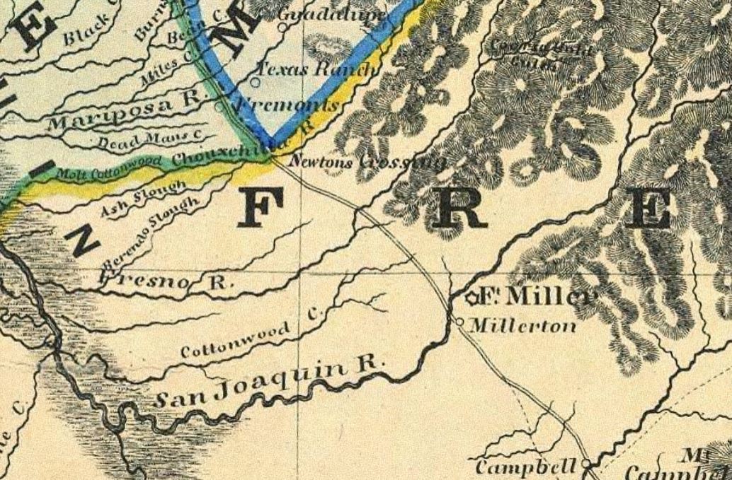
The Stockton-Los Angeles Road in Fresno County between the Chowchilla River and Millerton at the San Joaquin River can be seen on the 1857 Britton & Rey's Map of California.
As the Southern Pacific Railroad was being constructed through San Joaquin Valley during the late 1860s and 1870s a series of flood resistant frontage roads was constructed. These roads shifted the main path of overland travel south from the Stockton-Los Angeles Road to the new railroad communities such as Fresno. The Fresno County seat would relocate out of Millerton to Fresno in 1874.
Despite the overall decline of the Stockton-Los Angeles Road the corridor remained important to local travel in northern Fresno County. The highway would connect numerous stage roads north to the mines and logging operations found in places such Fresno Flats, Coarsegold and Crane Valley. In 1876 the town of Madera was plotted out along the Southern Pacific Railroad by the California Lumber Company. The then new community was connected to the Stockton-Los Angeles Road and Fresno-Fresno Flats Road (now Madera County Road 211) by a new highway which largely comprises modern California State Route 145 in addition to the remaining portion of modern Madera County Road 208.
The road from Madera east to the Fresno-Fresno Flats Road can be seen in detail on the 1891 Thompson Atlas of Fresno County. The segment which would later be incorporated into Legislative Route Number 126 can be seen originating in Madera at Township 11S, Range 18E and extending east to Township 10S, Range 20E. Madera County would be incorporated out of what was Fresno County north of the San Joaquin River on May 16, 1893.

The road from Madera to the Fresno-Oakhurst Road (formerly Fresno Flats) can be seen in detail on the 1914 Madera County Surveyor's Map.

During 1921 Bellview siding of the Minarets & Western Railroad would be established at the end of road connecting Madera to the Fresno-Fresno Flats Road. The entire corridor would come to be known for a time as "Bellview Road."
1933 Legislative Chapter 767 added Legislative Route Number 126 (LRN 126) to the State Highway System. The original definition of the state highway was:
"Fresno-Tracy Westside Highway near Kerman to LRN 4 near Madera (former US Route 99 on Gateway Drive) to Fresno-Yosemite Road (modern Madera County Road 209). "
LRN 126 (solid red lines) along Bellview Road east of Madera to the Fresno-Yosemite Road (LRN 125) can be seen on the 1935 Division of Highways Map of Madera County LRN 125 in Madera County would be designated as part of California State Route 41 when the initial run of Sign State Routes was announced in August 1934. The early alignment of LRN 125 displayed here is now Madera County Road 209.
The alignment of California State Route 41 around Bates Station was featured in the December 1939 California Highways & Public Works. The corridor described in the article began at Kelshaw Corners along Coarsegold Creek and extended ten miles southwest. The previous alignment is displayed as being routed past Bates Station via what is now Madera County Roads 209, 406 and 207. The new alignment saved three miles and was noted to be complete during late October 1939.


The new alignment of California State Route 41 bypassing Bates Station led LRN 126 being temporarily extended east of Fresno-Yosemite Road at Millers Corner (later Twenty-Two Mile House). LRN 126 itself was realigned to a new junction with California State Route 41 and the new Friant Dam approach road (now Madera County Roads 145 and 206) in 1940. The realignment is noted to be a cooperative project between the Division of Highways, Works Projects Administration and State Relief Administration in the January 1940 California Highways & Public Works.


LRN 126 would be designated as California State Route 145 in 1948. Bellview Road would be designated as "Road 208" when Madera County dropped naming conventions during the mid-twentieth century. Wide Awake Ranch would eventually purchase Road 208 between modern California State Route 145-Road 209 and prohibit public access.
Part 2; a drive along former Legislative Route Number 126 on Madera County Road 208
A small portion of former LRN 126 west on Road 208 of California State Route 41 at Twenty-Two Mile House is still accessible to the public west to Road 209.


Former LRN 126 west of Road 209 still exists but is gated off by Wide Awake Ranch.

Comments