Welcome to the gateway page for Gribblenation’s series on the bridges of the Ohio River in Louisville, KY! Here you will find links to information about the two bridges that span the river within the city limit of Louisville between southern Indiana and northern Kentucky. The present-day bridges of Louisville were constructed during the periods including the peak railroading era of the late 1800s and the height of the modern interstate highway era of the 1960s through the present day. Each has a unique story to tell and they play a vital part in the transportation system of this corner of the Ohio Valley region.
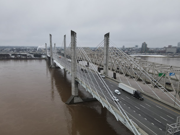
Cover Photo: From left to right, the John F. Kennedy Memorial Bridge (1963) and the Abraham Lincoln Bridge (2015) combine to carry Interstate 65 traffic across the Ohio River near downtown Louisville, creating one of the most impressive bridge-related visuals in the Ohio Valley.
Lewis & Clark Bridge
Known on planning maps for decades prior as the "East End Bridge", the construction of the Lewis & Clark Bridge (completed in 2016) was an important component of the regional Ohio River Bridges Project and completed the "missing link" in the Interstate 265/Gene Snyder Freeway beltway that encircles the eastern half of greater Louisville.
Big Four Railroad Bridge
Located a short distance upriver from downtown Louisville, the Big Four Bridge was completed in 1895 and after many years of abandonment was refurbished and returned to service as a scenic pedestrian bridge. Itt took its name from the now-defunct Cleveland, Cincinnati, Chicago, and St. Louis Railway, which was nicknamed the "Big Four Railroad".Abraham Lincoln Bridge
Completed in 2015 as part of the landmark Ohio River Bridges Project, the Abraham Lincoln Bridge carries Interstate 65 northbound traffic between downtown Louisville and Jeffersonville, IN adjacent to the John F. Kennedy Memorial Bridge, which itself carries I-65 southbound traffic.
John F. Kennedy Memorial Bridge
Opened in 1963, the Kennedy Bridge carries Interstate 65 southbound traffic between Jeffersonville, IN and downtown Louisville adjacent to the Abraham Lincoln Bridge, which itself carries I-65 northbound traffic.George Rogers Clark Memorial Bridge
Sometimes known locally as the "Second Street Bridge", this bridge opened in 1929 and connects downtown Louisville with suburban Jeffersonville. It's become a more significant crossing in recent years, as it's now the lone toll-free bridge across the Ohio River linking to central Louisville from the north.Fourteenth Street (Ohio Falls) Railroad Bridge
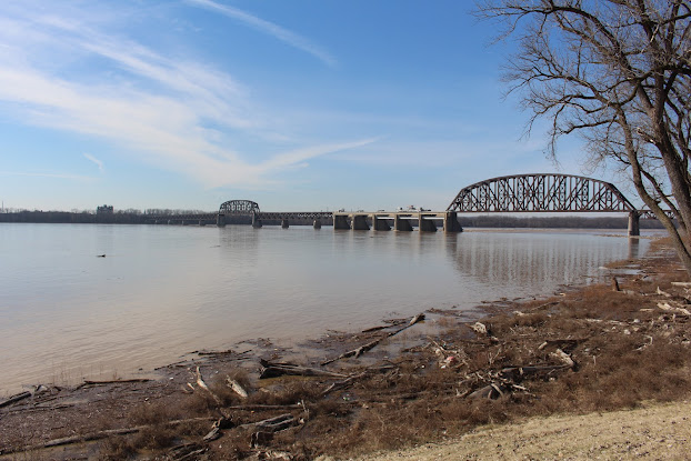
Located near the widest point in the Ohio River, the Fourteenth Street Bridge carries railroad traffic across the Falls of the Ohio and the upriver terminal of the Louisville & Portland Canal. A massive structural expansion of the bridge atop its original 1870 foundations was completed in 1919.McAlpine Locks & Dam
The construction of the original Louisville & Portland Canal in 1830 was an enormous technological success that enabled shipping traffic to bypass the Falls of the Ohio across from downtown Louisville. Today, the components of the expanded McAlpine Locks & Dam complex make up one of the most important navigational and electricity generating locations on the Ohio River.
Kentucky & Indiana Terminal Railroad Bridge
Built in 1912 as a replacement for a previous bridge at the same location, the "K&I" Bridge was the first multi-modal bridge built across the Ohio River in the Louisville area (and among the first nationally). While its roadways have been closed since 1979, the bridge remains active today as a railroad crossing.Sherman Minton Bridge
The Sherman Minton Bridge features a rare M-shaped, double-deck superstructure and has carried Interstate 64 across the Ohio River between Louisville's West End and New Albany, IN since 1962.Ohio River Bridges Project: A Historical Overview
Conceived in the early 2000s and built in the 2010s, the regional "Ohio River Bridges Project" was a massive undertaking aimed at reducing traffic congestion on the downtown Louisville freeway system by completing the missing link in the I-265 beltway east of town and expanding capacity along I-65 at the Kennedy Interchange. The resulting $2.5 billion project was completed in 2016 and saw the construction of two new bridges across the Ohio River, among other significant improvements.Lewis & Clark Bridge (2016)
Big Four Railroad Bridge (1895)
Abraham Lincoln Bridge (2015)
John F. Kennedy Memorial Bridge (1963)
George Rogers Clark Memorial Bridge (1929)
Fourteenth Street (Ohio Falls) Railroad Bridge (1870/1919)
McAlpine Locks & Dam (1830/2009)
Kentucky & Indiana Terminal Railroad Bridge (1912)
Sherman Minton Bridge (1962)
Ohio River Bridges Project: A Historical Overview


Comments