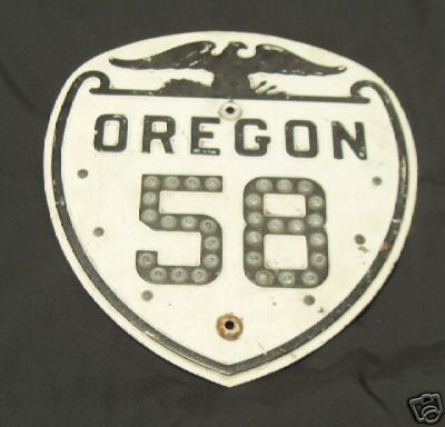
EBay: Would you pay $2600.50 for this?

It's a beauty no doubt, a cutout Oregon Highway 58 shield complete with Button Copy or Cats-Eyes numerals. It's embossed and was on a recent auction on ebay. Ok so maybe $100 or $200 even $250. But it went for $2600.50!!!! Yes, Two thousand, six hundred dollars and fifty cents! You can re-read that now...............

Ok, I own a few signs, and sign collecting is a part of this hobby. But I've yet to pay over $65 for one, and even then I had buyer's remorse. But $2600.50! Heck, I'm saving to buy new living room furniture next year, and this sign alone is greater than I am planning on spending. Maybe putting a sign or two on ebay will help pay for it.

Yeah for some you could say it's an investment, but who is gonna pretty much pay even more than $2600.50 for it when the poor guy passes away or decides to sell.

That's just a little too much for me.

What do you think? Would you pay that much for a sign? And what do you think the fair market value is for the sign above?

Comments

Anonymous said…
While $2600 is a lot to pay for a sign, I feel it is better preserved in this order than rusting away in a scrap heap. Reminds me of a few discussions the crew over at the IRC #roadgeek chat (at irc.zuh.net for those who are interested in dropping by some evening) have talked about in the past, in terms of procuring old signs. While I would not pay more than about $50 for a sign, I have been told that one way of getting an old sign for your collection is from the local DOT after the local DOT does a sign replacement. Some offices may be willing to legally hand over the sign to you if you ask nice enough. When I lived in Buffalo a few years ago, the City of Tonawanda's DPW replaced a vintage I-290 New York shield (example at http://www.interstate-guide.com/ishields/images/i-290_ny_02.jpg ) with the monstrosity of http://www.gribblenation.net/nypics/regional/erie/northtowns/i290md2.jpg. I do regret not contacting Tonawanda about getting the old school sign, and it's quite possible that it made its way elsewhere after 3 years. Still, I can think of better uses of spending $2600, regardless of whether they are fun expenditures or the necessary bills.

Popular posts from this blog

Interstate 40's Tumultuous Ride Through the Pigeon River Gorge

In the nearly 60 years Interstate 40 has been open to traffic through the Pigeon River Gorge in the mountains of Western North Carolina, it has been troubled by frequent rockslides and damaging flooding, which has seen the over 30-mile stretch through North Carolina and Tennessee closed for months at a time. Most recently, excessive rainfall from Hurricane Helene in September 2024 saw sections of Interstate 40 wash away into a raging Pigeon River. While the physical troubles of Interstate 40 are well known, how I-40 came to be through the area is a tale of its own. Interstate 40 West through Haywood County near mile marker 10. I-40's route through the Pigeon River Gorge dates to local political squabbles in the 1940s and a state highway law written in 1921. A small note appeared in the July 28, 1945, Asheville Times. It read that the North Carolina State Highway Commission had authorized a feasibility study of a "...water-level road down [the] Pigeon River to the Tennessee l

Mines Road

Mines Road is an approximately twenty-eight-mile highway located in the rural parts of the Diablo Range east of the San Francisco Bay Area.  Mines Road begins in San Antonio Valley in Santa Clara County and terminates at Tesla Road near Livermore of Alameda County.  The highway essentially is a modern overlay of the 1840s Mexican haul trail up Arroyo Mocho known as La Vereda del Monte.  The modern corridor of Mines Road took shape in the early twentieth century following development of San Antonio Valley amid a magnesite mining boom.  Part 1; the history of Mines Road Modern Mines Road partially overlays the historic corridor used by La Vereda del Monte (Mountain Trail).  La Vereda del Monte was part of a remote overland route through the Diablo Range primarily used to drive cattle from Alta California to Sonora.  The trail was most heavily used during the latter days of Alta California during the 1840s. La Vereda del Monte originated at Point of Timber between modern day Byron and Bre

Interstate 210 the Foothill Freeway

The combined Interstate 210/California State Route 210 corridor of the Foothill Freeway is approximately 85.31-miles.  The Interstate 210/California State Route 210 corridor begins at Interstate 5 at the northern outskirts of Los Angeles and travels east to Interstate 10 in Redlands of San Bernardino County.  Interstate 210 is presently signed on the 44.9-mile segment of the Foothill Freeway between Interstate 5 and California State Route 57.  California State Route 210 makes up the remaining 40.41 miles of the Foothill Freeway east to Interstate 10.  Interstate 210 is still classified by the Federal Highway Administration as existing on what is now signed as California State Route 57 from San Dimas south to Interstate 10.  The focus of this blog will mostly be on the history of Interstate 210 segment of the Foothill Freeway.   Part 1; the history of Interstate 210 and California State Route 210 Interstate 210 (I-210) was approved as a chargeable Interstate during September of