Part 1; the history of Knight's Ferry and the Knight's Ferry Covered Bridge
What is now Knight's Ferry was explored in 1844 during the Second Fremont Expedition. Captain William Knight whom was a member of the Second Fremont Expedition returned to the site 1849 to establish a ferry crossing of the Stanislaus River. Having been founded during the height of the California Gold Rush the community around Knight's Ferry soon rose in importance. A flour mill opened in Knights Ferry by 1850 which replaced by a far larger facility in 1854 a large flour mill. By 1857 a wooden bridge had been constructed over the Stanislaus River.
Knight's Ferry can be seen on the road between Stockton and Sonora on 1857 Britton & Rey's Road Map of California.

In 1862 Knight's Ferry became the fourth Stanislaus County Seat replacing La Grange. Despite becoming the Stanislaus County Seat the community of Knight's Ferry would suffer massive damages from the Great Flood of 1862. The Great Flood of 1862 destroyed the 1854 Flour Mill and 1857 Bridge over the Stanislaus River. By 1863 a new flour mill built by David Tulloch and what was known as the Knight's Ferry Covered Bridge were constructed from 1863 through 1864. The Knight's Ferry Covered Bridge is a four span design which towers over the Stanislaus River at 330 feet in length. The Knight's Ferry Covered Bridge remains the longest Covered Bridge in the United States west of the Mississippi River.

The Knight's Ferry Covered Bridge operated as a Franchise Toll Road when opened in 1864. In 1872 Knight's Ferry would lose the Stanislaus County Seat to Modesto. Modesto was located on the newly constructed Southern Pacific Railroad in San Joaquin Valley. Upon the completion of the Southern Pacific Railroad in San Joaquin Valley communities like Knight's Ferry in the Sierra Nevada Foothills quickly became obsolete as highway corridors. During the early California Gold Rush communities in the Sierra Nevada Foothills were often located on narrow river crossings which were less flood prone than the swampy San Joaquin Valley, Knight's Ferry was no exception. Once the Southern Pacific Railroad was completed in San Joaquin Valley the previous flooding concerns were rendered mute. Indeed Knight's Ferry isn't even shown to be a major highway on the 1873 Bancroft's Map of California.

The Knight's Ferry Covered Bridge was purchased by Stanislaus County in 1885 and was converted into a public road. The Knight's Ferry Covered Bridge can be seen connecting the communities of Buena Vista over the Stanislaus River to Knight's Ferry as part of Sonora Road on the 1906 Official Map of Stanislaus County.

In 1899 the Tulloch Mill was converted into a Hydroelectric Generation Station which operated until 1927. In the 1970s the Army Conservation Corps purchased the Tulloch Mill and began efforts to preserve it. The Knight's Ferry Covered Bridge closed to vehicle traffic in June of 1981 and rehabilitated in 1989.
Part 2; a visit to the Knight's Ferry Covered Bridge, Tulloch Mill, and Knight's Ferry
The Knight's Ferry Covered Bridge and Tulloch Mill are located in the Knight's Ferry Recreation Area. The Knight's Ferry Recreation Area is located on Sonora Road on both banks of the Stanislaus River.


I approached the Knight's Ferry Covered Bridge from the south bank of the Stanislaus River.


Hikers to the Knight's Ferry Covered Bridge are greeted by a historic plaque on the south bank of the Stanislaus River.


I crossed the Knight's Ferry Covered Bridge to the north bank of the Stanislaus River.


The Tulloch Mill is located on the north bank of the Stanislaus River next to the Knight's Ferry Covered Bridge. The upper level of the Tulloch Mill resembles a typical Gold Rush era structure and doesn't resemble a generating station.


Remains of the turbine and power generating station can be found on the lower levels of the Tulloch Mill.


Below Tulloch Mill the ditches used to channel water from the Stanislaus River into the generation station penstock can be explored.


The two mill stones from the 1854 flour mill can be found immediately west of Tulloch Mill.


The 1854 mill house can be found immediately north of Tulloch Mill. The 1854 mill house was used for the power plant manager from when Tulloch Mill was converted to a generation station until it shuttered in 1927.


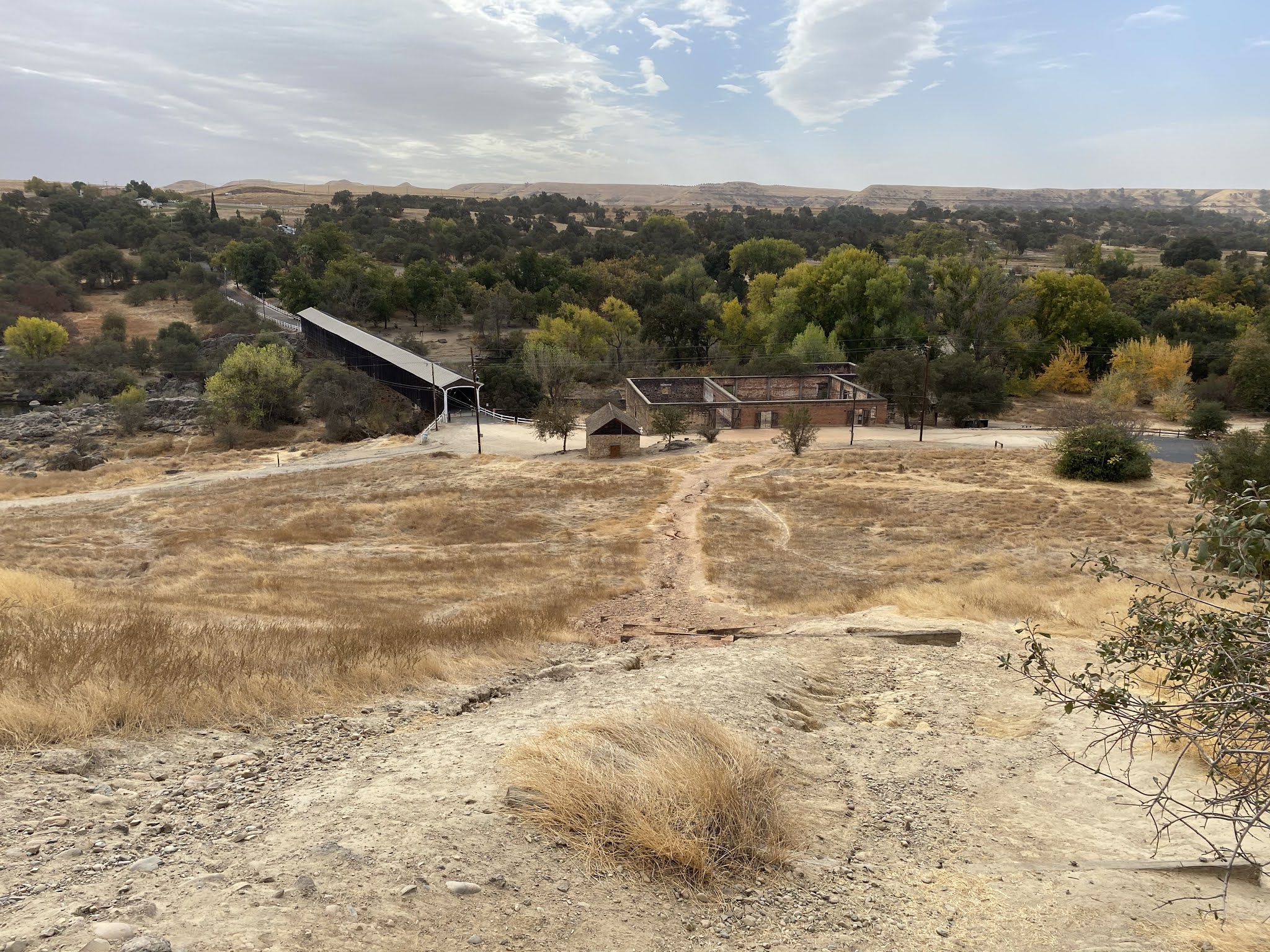
A hill behind the mill house bears evidence as likely being used as part of the power generation station at Tulloch Mill. From the top of the hill there is a commanding view of the Knight's Ferry Covered Bridge and Tulloch Mill.


Upon leaving Tulloch Mill I hiked back across the Knight's Ferry Covered Bridge. Upon returning to my car I drove modern Sonora Road over the north bank of the Stanislaus River and westward into Knight's Ferry proper. Knight's Ferry is awash in historic structures from the California Gold Rush and 19th Century.


Of note; there isn't much evidence of the community of Buena Vista on the south bank of the Stanisalus River aside from a historic plaque. The plaque describes Buena Vista as likely have been settled in 1850 and having a peak population nearing one hundred fifty residents. The population of Buena Vista is stated to have been a mix of white settlers and members of local tribes.

Old Sonora Road on the south bank of the Stanislaus River is located at the town site and is presently known as Shuper Road. Shuper Road dead ends at a turnaround just short of the Knight's Ferry Covered Bridge.

Comments