After returning to US Route 191 from Utah State Route 313 I turned south towards Moab and Arches National Park.

This blog serves as Part 16 of the 2016 Fall Mountain Trip Series; Part 15 can be found here:
2016 Fall Mountain Trip Part 15; A Dead Horse of course and Utah State Route 313
Modern access to Arches National Park from US Route 191 is via the Arches Scenic Drive which is located slightly north of the Colorado River and UT 279. From the entrance station of Arches National Park the Arches Scenic Drive climbs above the Moab Fault and provides a vista of US 191.

Access to Arches National Park used to be via the first Utah State Route 93. UT 93 used to run from what was US 160 (modern US 191) directly east into Arches National Monument along Willow Springs Road. UT 93 would enter Arches National Monument approximately where the Balanced Rock Trailhead Parking Lot is located now. Former UT 93 is still a maintained roadway and is listed as Bureau of Land Management Route 378 on most maps. The Arches Scenic Drive first appears on topographical maps sometime between 1952 and 1960, the current UT 93 designation on the I-15 corridor dates back to 1961. The original UT 93 can be observed entering Arches National Monument on this 1950 State Highway Map.
1950 State Highway Map
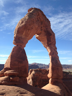
Arches National Park was first designated as a National Monument back in 1929. The National Monument was designated as a National Park by 1971 and is quite popular with an annual draw near two million visitors. The signature attraction of Arches National Park is the natural sandstone arches which are a common sight. Arches National Park is largely known for the Delicate Arch which also happens to appear on the Utah State License Plate. The Delicate Arch is located in the north end of Arches National Park on the Delicate Arch Trail. Given that the Delicate Arch Trail is extremely popular I made my way up Arches Scenic Drive and Delicate Arch Road upon entering the park to make sure I could find a place to park at the trailhead. While the Delicate Arch Trail is steep the sandstone surface actually made for good enough footing that I found it was somewhat manageable to run.


Located at the of bottom the Delicate Arch Trail is the remains of Wolfe Ranch which was settled along Salt Wash in the late 1800s. The cabin building apparently dates back to 1906, kind of hard to envision how remote the ranch would have been during the time period.


From the Delicate Arch I returned to Arches Scenic Drive and drove north to the Devil's Garden area of Arches National Park. I spent a good part of the day looking for arches out in the northern extent of Arches National Park. Among the arches I found out on the hiking trails were the Sand Dune Arch and Broken Arch


Heading back southbound on Arches Scenic Drive I stopped at the Fiery Furnace Vista which overlooks a formation of eroded sandstone hoodoos.

As mentioned above UT 93 used to enter Arches National Monument at the trailhead parking for Balanced Rock.

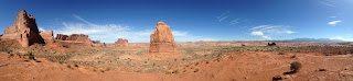
Probably the most scenic vista on Arches Scenic Drive is at the La Sal Mountains Viewpoint. Not only does the viewpoint overlook the La Sal Range but also Courthouse Towers and Park Avenue. If the view seems familiar it might be due to the fact that it was featured in the opening scene of Indiana Jones and the Last Crusade.
After returning to US 191 I continued south through Moab towards Blanding. My next stop was to the west at Natural Bridges National Monument.
Part 17 of this blog series can be found here:
2016 Fall Mountain Trip Part 17; Natural Bridges National Monument and Utah State Route 275

This blog serves as Part 16 of the 2016 Fall Mountain Trip Series; Part 15 can be found here:
2016 Fall Mountain Trip Part 15; A Dead Horse of course and Utah State Route 313
Modern access to Arches National Park from US Route 191 is via the Arches Scenic Drive which is located slightly north of the Colorado River and UT 279. From the entrance station of Arches National Park the Arches Scenic Drive climbs above the Moab Fault and provides a vista of US 191.

Access to Arches National Park used to be via the first Utah State Route 93. UT 93 used to run from what was US 160 (modern US 191) directly east into Arches National Monument along Willow Springs Road. UT 93 would enter Arches National Monument approximately where the Balanced Rock Trailhead Parking Lot is located now. Former UT 93 is still a maintained roadway and is listed as Bureau of Land Management Route 378 on most maps. The Arches Scenic Drive first appears on topographical maps sometime between 1952 and 1960, the current UT 93 designation on the I-15 corridor dates back to 1961. The original UT 93 can be observed entering Arches National Monument on this 1950 State Highway Map.
1950 State Highway Map
Arches National Park was first designated as a National Monument back in 1929. The National Monument was designated as a National Park by 1971 and is quite popular with an annual draw near two million visitors. The signature attraction of Arches National Park is the natural sandstone arches which are a common sight. Arches National Park is largely known for the Delicate Arch which also happens to appear on the Utah State License Plate. The Delicate Arch is located in the north end of Arches National Park on the Delicate Arch Trail. Given that the Delicate Arch Trail is extremely popular I made my way up Arches Scenic Drive and Delicate Arch Road upon entering the park to make sure I could find a place to park at the trailhead. While the Delicate Arch Trail is steep the sandstone surface actually made for good enough footing that I found it was somewhat manageable to run.


Located at the of bottom the Delicate Arch Trail is the remains of Wolfe Ranch which was settled along Salt Wash in the late 1800s. The cabin building apparently dates back to 1906, kind of hard to envision how remote the ranch would have been during the time period.


From the Delicate Arch I returned to Arches Scenic Drive and drove north to the Devil's Garden area of Arches National Park. I spent a good part of the day looking for arches out in the northern extent of Arches National Park. Among the arches I found out on the hiking trails were the Sand Dune Arch and Broken Arch


Heading back southbound on Arches Scenic Drive I stopped at the Fiery Furnace Vista which overlooks a formation of eroded sandstone hoodoos.

As mentioned above UT 93 used to enter Arches National Monument at the trailhead parking for Balanced Rock.

Probably the most scenic vista on Arches Scenic Drive is at the La Sal Mountains Viewpoint. Not only does the viewpoint overlook the La Sal Range but also Courthouse Towers and Park Avenue. If the view seems familiar it might be due to the fact that it was featured in the opening scene of Indiana Jones and the Last Crusade.

After returning to US 191 I continued south through Moab towards Blanding. My next stop was to the west at Natural Bridges National Monument.
Part 17 of this blog series can be found here:
2016 Fall Mountain Trip Part 17; Natural Bridges National Monument and Utah State Route 275
Comments