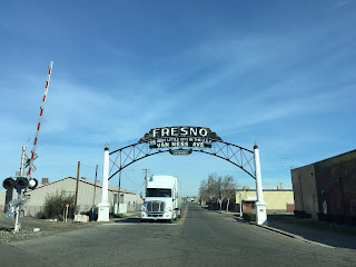
1929 Van Ness Arch; Van Ness Avenue, Fresno California


Recently I decided to re-visit the Van Ness Arch after seeing a Google image of it blocked off by Union Pacific construction.  The Van Ness Arch was located just off of US Route 99/Railroad Avenue at the rail crossing on Van Ness Avenue in southern Fresno.

This blog is part of the larger Gribblenation US Route 99 Page.  For more information pertaining to the other various segments of US Route 99 and it's three-digit child routes check out the link the below.


The Van Ness Arch of Fresno

An archway at Railroad Avenue and Van Ness Avenue was first proposed by the City of Fresno along Legislative Route Number 4 (future US 99) first in 1915.  The original Van Ness Arch was completed in 1917 but only lasted to 1925 when it was damaged by fire.  The current Van Ness Arch dates back to 1929 and features an Arc Deco design.  The 1929 Van Ness Arch states the following greeting: "Fresno, the best little city in the USA, Van Ness Avenue."


Despite the Van Ness Arch being completed only by 1929 the alignment of US 99 shifted to the west off of Railroad Avenue to a wider rail approach into downtown by 1930.  At some point between 1930 the route of Railroad Avenue to the Van Ness Arch may have been signed as a US 99 business route.  Previously I covered the surface route of US 99 in Fresno on the blog below:

Hunting Forgotten History; US Route 99 in Fresno

The fate of the Van Ness Arch is uncertain as access to it will be eventually bisected by the High Speed Rail project.  Said project may also lead to the demolition of former US Route 99 on Railroad Avenue.  Back in 2013 the FresnoBee published a story regarding the history of the Van Ness Arch.

Fresno's Van Ness Avenue welcome arch

Comments

Unknown said…
Don't run the bullet train thru the arch area.This is an historic arch that needs to be preserved.If at all possible,move it a bit north on Van Ness.Once gone,history will be forgotten.

Popular posts from this blog

Interstate 40's Tumultuous Ride Through the Pigeon River Gorge

In the nearly 60 years Interstate 40 has been open to traffic through the Pigeon River Gorge in the mountains of Western North Carolina, it has been troubled by frequent rockslides and damaging flooding, which has seen the over 30-mile stretch through North Carolina and Tennessee closed for months at a time. Most recently, excessive rainfall from Hurricane Helene in September 2024 saw sections of Interstate 40 wash away into a raging Pigeon River. While the physical troubles of Interstate 40 are well known, how I-40 came to be through the area is a tale of its own. Interstate 40 West through Haywood County near mile marker 10. I-40's route through the Pigeon River Gorge dates to local political squabbles in the 1940s and a state highway law written in 1921. A small note appeared in the July 28, 1945, Asheville Times. It read that the North Carolina State Highway Commission had authorized a feasibility study of a "...water-level road down [the] Pigeon River to the Tennessee l

Ghost Town Tuesday; Mannfield, FL and the stairway to Hell

Back in 2015 I went searching the Lecanto Sand Hills for the original Citrus County Seat known as Mannfield.  Unlike Centrailia in Hernando County and Fivay in Pasco County I did find something worth seeing. Mannfield is located in the Lecanto Sand Hill section of Withlacoochee State Forest somewhat east of the intersection of Citrus County Route 491 and Mansfield Road. Mannfield was named after Austin Mann and founded in Hernando County in 1884 before Citrus County Split away.  In 1887 Citrus County was split from northern Hernando County while Pasco County was spun off to the south.  Mannfield was selected as the new Citrus County seat due to it being near the county geographic center.  Reportedly Mannfield had as many as 250 people when it was the County Seat.  The town included various businesses one might include at the time, even a sawmill which was common for the area.  In 1891 Citrus County voted to move it's seat to Inverness which set the stage for the decline of M

The National Road - Pennsylvania - Great Crossings Bridge and Somerfield

West of Addison, US 40 crosses the Youghiogheny River at what once was the town of Somerfield.  When crossing the current modern two lane bridge, you many not realize that it is actually the third to cross the Yough at this site.  The first - a stone arch bridge - was known as the Great Crossings Bridge.  Built in 1818, this three arch bridge was part of the original National Road.  The name Great Crossings comes from the men who forded the Youghiogheny here - George Washington and George Braddock. (1)  If you cross the bridge at the right time, this historic bridge and what was once the town of Somerfield will appear out from underneath this massive man-made lake. Historical Postcard showing the 'Big Crossings' bridge and Somerfield.  Image submitted by Vince Ferrari. The Great Crossings Bridge was located in the town of Somerfield.  Somerfield, originally named Smythfield until 1827, would develop as a result of the National Road. (1)  Somerfield would go through va