While on a recent trip through Ontario I returned to the United States via the Ambassador Bridge.

The Ambassador Bridge connects King's Highway 3 in Windsor, Ontario to Interstates 75 and 96 in Detroit, Michigan. The Ambassador Bridge crosses the Detroit River which serves as the International Boundary between Canada and the United States. The Ambassador Bridge is the busiest trade crossing between Canada and the United States carrying close to a quarter of freight between the two countries.
The first study to construct a bridge over the Detroit River was ordered by the United States Congress in 1889 but ultimately was not approved. Plans to build a bridge over the Detroit River weren't revisited until 1919 which ultimately resulted in construction of the Ambassador Bridge beginning in August of 1927. The Ambassador Bridge opened to traffic in November of 1929.
The Ambassador Bridge is a suspension design which carries four lanes of undivided traffic. The Ambassador Bridge is 7,500 feet in length with the longest span being 1,850 feet in length. The maximum clearance beneath the roadway to the Detroit River is 152 feet. The Ambassador Bridge is presently owned/maintained by the Detroit International Bridge Company and Canadian Transit Company. The private ownership of the Ambassador Bridge has been contentious which is a far longer story than I'm willing to go into in a blog post.
My approach to the Ambassador Bridge was from King's Highway 3 on Church Huron Road from King's Highway 401.


Traffic on the Ambassador Bridge is directed to stay on KH 3.

At College Avenue the westbound approach for the Ambassador Bridge begins.

Traffic onto the Ambassador Bridge is routed around the Canadian Customs Station.


The Ambassador Bridge begins to climb over the Detroit River. Both support spans display a large sign stating "Ambassador Bridge."


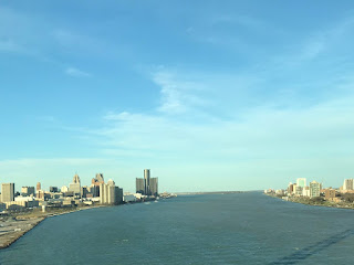
From the central span of the Ambassador Bridge heading westbound the skyline of downtown Detroit can be seen.
The Ambassador Bridge crosses over the Detroit River into the City of Detroit.


Cars are directed to stay left approaching the U.S. Customs Station. Approaching the Custom Station the Michigan Central Station can be seen off the to the right.


As of September 2012 the Ambassador Bridge directly accesses I-75 and I-96.

Originally the Ambassador Bridge in Detroit was accessed from Porter Street between 21st and 22nd Streets. The original access configuration of the Ambassador Bridge can been seen on this 1956 Rand McNally map of downtown Detroit.
1956 Downtown Detroit Highway Map
I don't have a ton of pictures of the Ambassador Bridge but for what it's worth this one is from Belle Isle in 2015 during a rain storm.


The Ambassador Bridge connects King's Highway 3 in Windsor, Ontario to Interstates 75 and 96 in Detroit, Michigan. The Ambassador Bridge crosses the Detroit River which serves as the International Boundary between Canada and the United States. The Ambassador Bridge is the busiest trade crossing between Canada and the United States carrying close to a quarter of freight between the two countries.
The first study to construct a bridge over the Detroit River was ordered by the United States Congress in 1889 but ultimately was not approved. Plans to build a bridge over the Detroit River weren't revisited until 1919 which ultimately resulted in construction of the Ambassador Bridge beginning in August of 1927. The Ambassador Bridge opened to traffic in November of 1929.
The Ambassador Bridge is a suspension design which carries four lanes of undivided traffic. The Ambassador Bridge is 7,500 feet in length with the longest span being 1,850 feet in length. The maximum clearance beneath the roadway to the Detroit River is 152 feet. The Ambassador Bridge is presently owned/maintained by the Detroit International Bridge Company and Canadian Transit Company. The private ownership of the Ambassador Bridge has been contentious which is a far longer story than I'm willing to go into in a blog post.
My approach to the Ambassador Bridge was from King's Highway 3 on Church Huron Road from King's Highway 401.


Traffic on the Ambassador Bridge is directed to stay on KH 3.

At College Avenue the westbound approach for the Ambassador Bridge begins.

Traffic onto the Ambassador Bridge is routed around the Canadian Customs Station.


The Ambassador Bridge begins to climb over the Detroit River. Both support spans display a large sign stating "Ambassador Bridge."


From the central span of the Ambassador Bridge heading westbound the skyline of downtown Detroit can be seen.

The Ambassador Bridge crosses over the Detroit River into the City of Detroit.


Cars are directed to stay left approaching the U.S. Customs Station. Approaching the Custom Station the Michigan Central Station can be seen off the to the right.


As of September 2012 the Ambassador Bridge directly accesses I-75 and I-96.

Originally the Ambassador Bridge in Detroit was accessed from Porter Street between 21st and 22nd Streets. The original access configuration of the Ambassador Bridge can been seen on this 1956 Rand McNally map of downtown Detroit.
1956 Downtown Detroit Highway Map
I don't have a ton of pictures of the Ambassador Bridge but for what it's worth this one is from Belle Isle in 2015 during a rain storm.

Comments