Travel New England: Deerfield Village


Deerfield is one of the oldest Massachusetts settlements within the Connecticut River Valley. Settled in 1673, Deerfield was one of the furthest outposts of the early Colonial period. Deerfield and its surrounding areas were heavy in agriculture in the fertile fields of what is now known as the Pioneer Valley.

Old Main Street - Deerfield Village

Within modern day Deerfield is the Historic Old Deerfield Village.  A New England version of Colonial Williamsburg, Deerfield Village is a walk through to 18th Century New England.   Much of the old village sits along a one mile stretch of Old Main Street.  Here numerous historic homes and farmhouses from the 18th centuries can be found.  


With a basic admission of $18 per adult, you are able to walk inside and tour the grounds and many of the homes within Historic Deerfield.  Some homes have guided tours while others are self guided.  At various places with in town, you can see woodworking or cooking demonstrations or take a stop at the Carriage Barn.  When I visited in 2006, a wonderful 91 year old man, who did not look a day of it, tells stories about carriages and farm equipment from the 17th to the early 20th century.
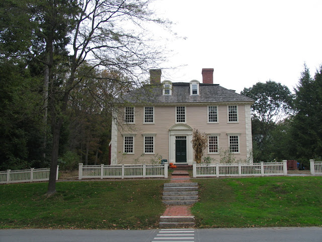
One of the many 18th century homes within Historic Deerfield.

Most of the guided tours are on the hour by members of Historic Deerfield.  Parking is easy and for the most part, it is on either side of the quaint town road.  There is also a gift shop and bookstore.  The Visitor's Center is located within Hall Tavern.  The tavern was built in 1760 in Charlemont and moved to Deerfield.  The Tavern will sometimes host cooking demonstrations and also is home to a cook's garden.

An old fire call box and weathered American flag on the exterior of the Deerfield Fire Station.

Visitors that want to fully immerse themselves within the town can stay overnight at the historic Deerfield Inn which has been operating since 1884.  Or if passing through, enjoy lunch at Champney's Restaurant & Tavern.

The Deerfield Inn offers lodging and meals at Champney's Restaurant and Tavern.

Old Deerfield is a National Historic District and also listed in the National Register of Historic Places.  The preservation of the village under Historic Deerfield began in 1952 as a continuation of the work of Mr. and Mrs. Henry Flynt. 

Deerfield Academy

Deerfield today is a town of just over 5,000 residents.  It is home to the Yankee Candle Flagship store in South Deerfield which attracts thousands.  Deerfield Academy, a private preparatory high school, is located within Historic Deerfield.  The highly prestigious school has been in operation since 1797.

All photos taken by post author - September 30, 2006.

Further Reading:

How To Get There:

Comments

Popular posts from this blog

Hawaii Route 8930

Hawaii Route 8930 is a 2.5-mile State Highway on the Island of O'hau.  Hawaii Route 8930 is aligned over Kualakai Parkway over the course of its entire alignment south from Interstate H-1 to Kapolei Parkway.  Hawaii Route 8930 is one of the newest Hawaii Routes only having been completed during 2010.   This page is part of the Gribblenation O'ahu Highways page.  All Gribblenation and Roadwaywiz media related to the highway system of O'ahu can be found at the link below: https://www.gribblenation.org/p/gribblenation-oahu-highways-page.html Part 1; the history of Hawaii Route 8930 The history of Hawaii Route 8930 is brief given it is a modern facility.  Hawaii Route 8930 and what was known as "North-South Road" were built to facilitate the developing areas of Kapolei on western O'ahu.  According to hawaiihighways.com the first stage of Hawaii Route 8930 was completed from Kapolei Parkway north to Farrington Highway as a four-lane highway during November...

Madera County Road 607 and the Stockton-Los Angeles Road

Madera County Road 607 is an approximately seven-mile rural unsurfaced highway which spans from Road 600 near Raymond west to Road 29.   Road 607 west from Raymond Road Cemetery (established in 1905) is part of the Stockton-Los Angeles Road corridor surveyed in 1853. The corridor lies in the gap between Fresno Crossing at the Fresno River west to Newton's Crossing at the Chowchilla River. The Buchanan Copper Mine would be along what is now Road 607 in the namesake Buchanan Hollow during July 1863. The Buchanan Mine is thought to have once had a population of between 1,000-1,500 residents by the early 1870s. Copper prices would decline in the decade after the Civil War and much of the activity at Buchanan shifted towards cattle ranching. The last businesses in the community would shutter during World War II and it is now a true ghost town. Part 1; the history of Madera County Road 607 and the Stockton-Los Angeles Road What is now Road 607 was a component of the larger Sto...

Paper Highways; Interstate H-4 through downtown Honolulu

The Hawaiian Island of O'ahu is home to four Interstate Highways; H-1, H-2, H-3 and H-201.  Had history gone slightly differently during the 1960s a fifth Interstate corridor on O'ahu could have been constructed through downtown Honolulu and the neighborhood of Waikiki.  The proposed corridor of Interstate H-4 can be seen above as it was presented by the Hawaii Department of Transportation during October 1968 .   This page is part of the Gribblenation O'ahu Highways page.  All Gribblenation and Roadwaywiz media related to the highway system of O'ahu can be found at the link below: https://www.gribblenation.org/p/gribblenation-oahu-highways-page.html The history of proposed Interstate H-4 The corridor of Interstate H-4 was conceived as largely following what is now Hawaii Route 92 on Nimitz Highway and Ala Moana Boulevard.   Prior to the Statehood the first signed highways within Hawaii Territory came into existence during World War II.    Dur...