Northern California contains a curiosity in the form of the segmented California State Route 271. California State Route 271 exists in two segments which were both once US Route 101.

According to California Highways as of 1995 California State Route 271 ("CA 271") had an overall 15 miles assigned over two segments. CA 271 as noted above consists of former segments of US Route 101 ("US 101") which are located mostly in Mendocino County. According to 1995 traffic statistics CA 271 has one of the lowest average daily traffic counts which ranges from 90 vehicles a day to 980. The northern segment of CA 271 begins at US 101 in Cooks Valley of Humboldt County which can be seen depicted in the Caltrans Post Mile Tool:

The northern segment of CA 271 ends on a dead end road south of Piercy near US 101 Exit 625.

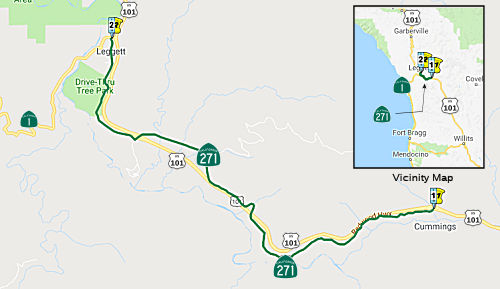
The southern segment of CA 271 begins at CA 1 in Leggett and ends at US 101 in Cummings. The southern segment if best depicted by California Highways CA 271 page:
Part 1; the history of California State Route 271
The history of what would become CA 271 begins with the approval of the
1909 First State Highway Bond Act.
The First State Highway Bond Act was approved by voters during 1910 and
was the genesis point of some of the most notable highways in
California. LRN 1 in it's original form was a
new State Highway which was designated between San Francisco north to
Crescent City. The route of LRN 1 would be extended to the Oregon State
Line during the 1919 Third State Highway Bond Act and was known as the
Redwood Highway. The planned LRN 1 can be seen aligned between Garberville of Humboldt County and Cummings of Mendocino County on the 1917 California State Automobile Association Map.

Prior to the construction of LRN 1 wagon borne traffic heading north from Cummings to Humboldt County had to ascend the treacherous Rattlesnake Grade (also known as the Bell Springs Grade). The Rattlesnake Grade is described in the July 1916 California Highway Bulletin as being only passable during the summer months. The initial north climb on the Rattlesnake Grade ascended grades as high as 20% the from Cummings to the 4,100 foot high Bell Springs Mountain. The descent from Bell Mountain to Dyerville (on CA 254/Avenue of the Giants) is described as having grades as steep as 30% amid an elevation drop of just over 3,900 feet. The construction of LRN 1 (then known as the Mendocino State Highway) sought to follow the Eel River watershed to bypass the Rattlesnake Grade. Note; the Rattlesnake Grade can be seen on the 1917 California State Automobile Association Map between Cummings and Dyerville.

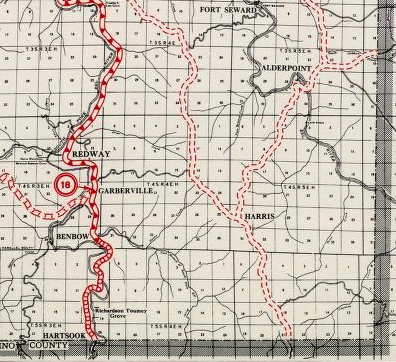
Much of the Rattlesnake Grade still exists as modern Bell Springs Road. The Rattlesnake Grade can be seen in detail between Garberville-Cummings on the 1935 Division of Highways Maps of Humboldt County and Mendocino County.


The completed Redwood Highway/LRN 1 between Cummings and Garberville can be seen on the 1920 Clason Highway Map of California.

In November 1926 the US Route System was created. US Route 101 from San Francisco north to Crescent City was aligned over the Redwood Highway. Both US 101 and the Redwood Highway between Garberville and Cummings can be seen on the 1927 Rand McNally Highway Map of California.

A new segment of the Redwood Highway between Piercy and Rock Creek can be seen in the October 1926 California Highways & Public Works just prior to it becoming US 101.

US 101/LRN 1 can be seen in detail between Garberville-Cummings on the 1935 Division of Highways Maps of Humboldt County and Mendocino County.


The November-December 1948 California Highways & Public Works discusses the straightening of US 101/LRN 1 between Red Mountain Creek and Piercy.

A slide clearing from the December 1955 Floods of Northern California can be seen on US 101 near Piercy in the March-April 1956 California Highways & Public Works.

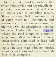
During the 1964 Christmas Floods US 101 between Garberville-Cummings saw substantial damage as it did also through most of northern California. The January-February 1965 California Highways & Public Works cited that US 101 near Leggett largely eroded down into the South Fork Eel River.
The March-April 1965 California Highways & Public Works cites that slides occurred on US 101 at; Leggett, Piercy, Richardson Grove, and Cummings during the 1964 Christmas Floods.

The Garberville-Cummings segment of US 101 initially remained mostly unchanged after the 1964 Christmas Floods which is evident on the 1967 Division of Highways State Map.

US 101 is shown as an expressway south of Garberville to the vicinity of Richardson Grove State Park on the 1969 Division of Highways State Map. US 101 is shown to have a planned bypass route of Richardson Grove State Park which shown continuing to an existing expressway segment near Cummings.

The 1970 Division of Highways State Map shows the Richardson Grove bypass under construction, ultimately it never would be completed.


Regarding the potential for a new CA 271 segment in Richardson Grove State Park it seems unlikely. The current Caltrans favored improvement for US 101 in Richardson Grove State Park is an expansion of the current highway and not a bypass. Much of the recent history of US 101 in Richardson Grove State Park can be found here.
Part 2; a drive on the northern segment of California State Route 271
US 101 south passes through Cook's Valley and intersects it's former alignment at the Northern Segment of CA 271 at Postmile HUM T0.08. The "T" Postmile designation at CA 271 serves as a trace reminder regarding the long dead planned US 101 bypass of Richardson Grove State Park.


The north segment of CA 271 heads south into Mendocino County. At Postmile Mile MEN 22.64 the north segment of CA 271 crosses the 1917 South Fork Eel River Bridge. The 1917 South Fork Eel River Bridge is an analog for early LRN 1 when it replaced the Rattlesnake Grade. The 1917 South Fork Eel River Bridge is a 183.1 foot long truss span carrying a 24 foot wide road deck. According to bridgehunter.com the 1917 South Fork Eel River Bridge was rehabilitated in 1934 by the McClinte-Marshall Corporation.


The north segment of CA 271 continues southward while following west of modern US 101. CA 271 continues south to Piercy and crosses under modern US 101 at Postmile MEN 19.45. Post Office Service in Piercy opened in 1920 when it was a hub on the Redwood Highway but the community has long declined to a ghost town.


The north segment of CA 271 continues southward while tracking east of modern US 101. At Postmile MEN 17.90 CA 271 crosses the 1935 McCoy Creek Bridge. The McCoy Creek Bridge is a 76.1 Timber Stringer span which was last rehabilitated in 1957.


The north segment of CA 271 continues south and crosses over modern US 101 Exit 625. As noted in the intro the north segment of CA 271 continues west of modern US 101 and terminates at Postmile MEN 16.94.

Part 3; a drive on the southern segment of California State Route 271
CA 271 is not multiplexed onto modern US 101 between the north segment the south segment. Reaching the south segment of CA 271 from southbound US 101 requires turning onto CA 1 southbound in Leggett.


CA 1 south intersects the south segment of CA 271 at Route 1 Postmile MEN 105.49.

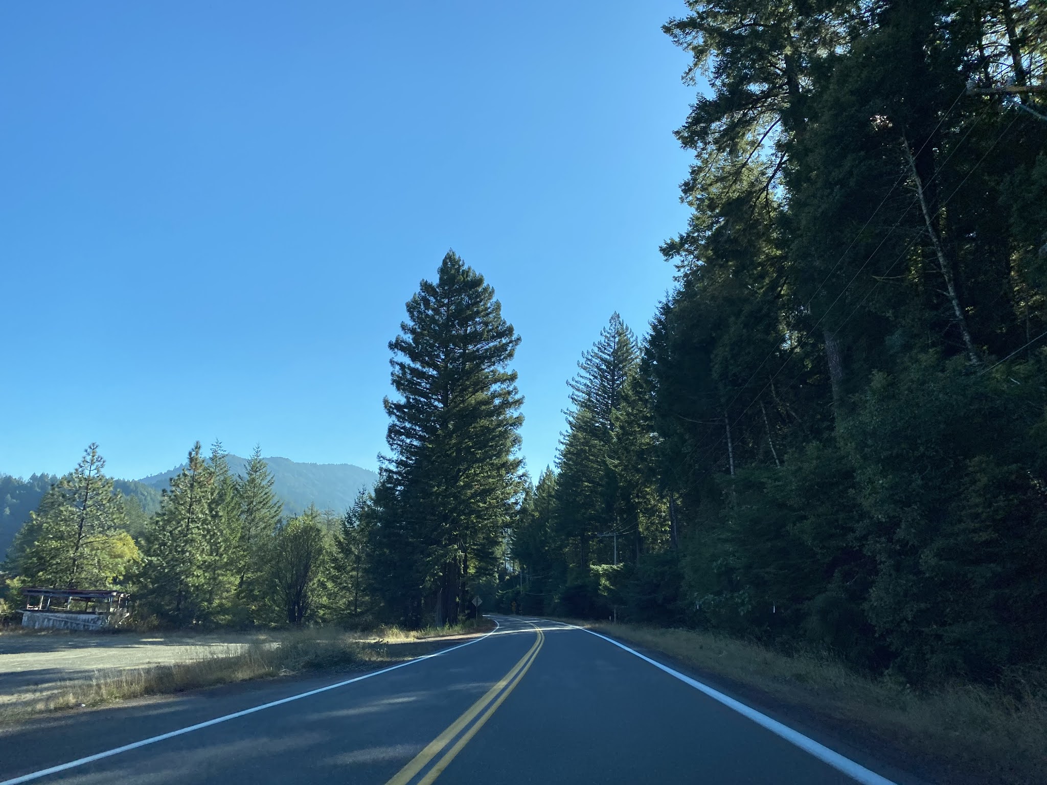
The south segment of CA 271 passes through Leggett and intersects the entrance to the Drive-Thru Tree at Postmile MEN 16.20. The Drive-Thru Tree (also known as the Chandelier Tree) is a 276 foot tall Coastal Redwood which is believed to have been carved by Charlie Underwood during the 1930s.


The south segment of CA 271 tracks west of modern US 101 and crosses under at approximately Postmile MEN 5.67. Strangely the south segment of CA 271 loses 8 miles in the Postmile Tool between the Drive-Thru Tree and US 101.


The south segment of CA 271 tracks east of US 101 and crosses the 1931 Cedar Creek Bridge at Postmile MEN 5.28. The 1931 Cedar Creek Bridge is a 609 foot long arch concrete span.

The south segment of CA 271 crosses the 1931 Big Dann Creek Bridge at Postmile MEN 4.97. The 1931 Big Dann Creek Bridge is also an arch concrete span and is 585 feet in length. I have no idea what the traffic gates on the Big Dann Creek Bridge or Cedar Creek Bridge are meant for.

The south segment of CA 271 crosses under modern US 101 at Postmile MEN 3.39.


The south segment of CA 271 tracks west of US 101 and terminates at the modern highway at Exit 609 in Cummings. Cummings was named after a local settler by the name of Jonathan Cummings when the Post Office set up service in 1888. Much like Piercy there isn't much to find today to suggest Cummings anything more than a ghost town.


Comments