The western segment of California State Route 16 is a largely scenic corridor which follows Cache Creek for much of it's alignment.

Present California State Route 16 ("CA 16") is a 82 mile State Highway which exists in two segments. Segment one of CA 16 is routed between CA 20 east to Interstate 5 ("I-5) near Woodland. Segment two of CA 16 exists from US Route 50 ("US 50") near Perkins east to CA 49 near Drytown. The focus of this blog will be on the western segment of CA 16.

Pertaining to the relinquished central segment of CA 16 in the greater Sacramento area more information can be found on the blog below:
Highways in and around Old Sacramento; US 40, US 99W, CA 16, CA 24, CA 70, CA 99, CA 275, and more
Part 1; the history of the western segment of California State Route 16
The predecessor to CA 16 was what would become Legislative Route Number 50 ("LRN 50") which was first added to the State Highway System as a survey ordered by the State of California as part of 1915 Legislative Chapter 283:
"commencing at
the town of Rumsey, in the county of Yolo and following generally the
meanderings of Cache Ck...to the town of Lower Lake, in the county of
Lake"
Said survey between Rumsey and Lower Lake appears to not have had a clear routing as it does not appear on the 1918 Division of Highways State Map.

As part of the 1919 Third State Highway Bond Act LRN 50 was formally defined as a highway between Rumsey and Lower Lake. Both LRN 50 and LRN 49 appear on the 1920 Division of Highways State Map
as a continuous State Highway west from Rumsey west to Lower Lake then
southward to Calistoga. The route of LRN 50 does not appear to
correspond to an actual roadway as it is shown following the main flow
of Cache Creek northeast from Lower Lake to the confluence of Cache
Creek and North Fork Cache Creek. Even the road east of the confluence
of North Fork Cache Creek/Cache Creek does not correspond to a roadway
that was ever constructed.

The 1922 Division of Highways Map
shows the planned route of LRN 50 between Lower Lake and Rumsey taking a
more southern angle way from the confluence of Cache Creek/North Fork
Cache Creek.

The 1926 Division of Highways State Map shows LRN 50 was realigned north of Lower Lake to LRN 15. LRN 50 followed LRN 15 east to Wilbur Spring where it split southeast towards Rumsey.
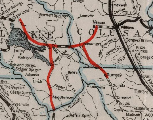
The January/February 1929 California Highways & Public Works described LRN 50 between Wilbur Springs and Rumsey as not constructed. There is a brief citation which states that LRN 50 would likely be built on a new grade which would not incorporate the existing road between Wilbur Springs and Rumsey.

The 1930 Division of Highways State Map subsequently only shows a couple miles of LRN 50 south of LRN 15 constructed. A proposed highway can be seen connecting southward to Rumsey.

According to CAhighways.org LRN 50 was extended in 1933 east from Rumsey east to LRN 7 in Woodland. The extension of LRN 50 east from Rumsey to Woodland was announced in the April 1933 California Highways & Public Works.


In the August 1934 California Highways & Public Works the entirety of LRN 50 was announced as a segment of CA 16.


Oddly CA 16 followed a State Maintained Highway east of Woodland to Sacramento. LRN 50 was clarified in 1935 when it was codified as a highway between:
"[LRN 15] to Sacramento via Rumsey and Woodland"
LRN 50 between LRN 15 ("CA 20") east to Sacramento can be seen in detail on the 1935 Division of Highways Maps of Colusa County and Yolo County. East from Woodland LRN 50/CA 16 can be seen following; Main Street, Old River Road, North Harbor Boulevard, Sacramento Avenue, C Street, and Kline Street to the I Street Bridge at the Sacramento River into Sacramento.


The full initial routing of CA 16 can be seen in more clear detail on the 1937 Gousha Highway Map of California. Note; CA 24 can be seen multiplexing CA 16 from Woodland east to Sacramento. CA 24 was extended from Woodland to the San Francisco Bay Area in 1935.

Not much would change with the present western segment of CA 16 until LRN 238 was adopted as the planned route of I-5 between Bakersfield and Woodland in 1957. Within the Sacramento Area I-5/LRN 238 was planned to follow the eastern bank of the Sacramento River towards Woodland whereas CA 16/CA 24/LRN 50 followed the western bank. LRN 238 appears as a proposed highway between Sacramento and Woodland on the 1958 Division of Highways State Map.


By 1960 CA 24 had been rerouted off of CA 16/LRN 50 onto LRN 232 from Maryville-Sacramento. This shift in CA 24 can be seen on the 1960 Division of Highways State Map.


CA 16 would eventually moved to a multiplex of; I-5, I-80, and US 50 from the I Street Bridge through Sacramento to the current eastern segment of the highway. This multiplex can be seen on the 1975 Caltrans State Map.

According to CAhighways.org the surface alignment of CA 16 between Woodland-Sacramento (specifically Conaway-Sacamento) and the I Street Bridge were relinquished in 1984. Regardless CA 16 is still shown multiplexing I-5 between Woodland-Sacramento on the 1986 Caltrans State Map.

Even the 1990 Caltrans State Highway Map shows CA 16 multiplexed with I-5 between Woodland-Sacramento. It is unclear what if any field signage existed to indicate a connecting route between the western and eastern segments of CA 16.

The 1990 Caltrans State Highway Map also shows CA 16 shifting off of Main Street to Road 98 in Woodland. This lead to the odd circumstance where the western segment of CA 16 and Yolo County Route E7 both terminate at I-5 via Road 98.

Part 2; a drive on the western segment of California State Route 16
The western segment of CA 16 begins from CA 20 near Bear Creek at Postmile COL 3.45.


From CA 20 the route ahead on CA 16 eastbound shows Rumsey 15 miles away and Woodland 50 miles away.

CA 16 east initially follows Bear Creek and is signed with an Elk Advisory for 6 miles.


CA 16 east follows Bear Creek southeast to the confluence with Cache Creek, at Postmile COL 7.25 CA 16 east enters Yolo County. Note; CA 16 carries a "D" suffixed Postmile supplement from the Yolo County up to COL D0.632. The "D" suffix indicates a duplicate Postmile at a meandering county line.


CA 16 east follows the meanderings of Cache Creek before emerging out of Rumsey Canyon at Postmile YOL 6.291. The Clear Lake-Rumsey Highway as noted in the August 1934 California Highways & Public Works carries an almost flat grade. It is likely that CA 16 and the Clear Lake-Rumsey Highway diverged from Cache Creek northwest up Bear Creek due to increasingly difficult terrain due west.


At Postmile YOL 7.14 CA 16 east enters Rumsey. Rumsey was originally settled in 1878 when it was known as "Rock." The community moved to the terminus of the Vaca Valley & Clear Lake Railroad in 1888 and was renamed to "Rumsey." The name "Rumsey" was taken from local land owner Captain D.C. Rumsey. Much of Rumsey was destroyed following the 1906 San Francisco Earthquake when Cache Creek was dammed by land slide. When the debris on Cache Creek gave way it flooded the community of Rumsey.


CA 16 east is signed as 5 miles from Guinda upon leaving Rumsey.

CA 16 east enters Guinda at Postmile 11.977. Guinda was another siding of the Vaca Valley & Clear Lake Railroad and was directly plotted by the Southern Pacific. Guinda takes it's name for a cherry tree which was found at the location of the new siding. Guinda received Post Office Service in 1889.


Departing Guinda CA 16 east is signed as 14 miles from Capay and 30 miles from Woodland.

CA 16 east passes by the Cache Creek Casino Resort at Postmile YOL 19.37.


CA 16 enters a 20 miles long Daytime Headlight corridor east of the Cache Creek Casino Resort.


CA 16 east enters Capay at Postmile YOL 25.79. Capay takes it's name from the Mexican Land Grant known as Rancho Canada de Capay. The community of Capay was originally settled in 1857 and came to be known as Munchville (an awesome name taken from the first modern settler). Munchville eventually became Langville which took it's name from a local hotel owner in the 1870s. The modern name of Capay was assumed in 1875.


CA 16 east intersects Yolo County Route E4 at Postmile YOL 25.67 in Capay.

Departing Capay CA 16 is signed as 2 miles from Esparto and 16 miles from Woodland.

CA 16 east enters Esparto at Postmile 26.36 as Woodland Avenue.


At approximately Postmile YOL 27.67 a box car can be found on CA 16/Woodland Avenue in Esparto. Esparto was settled as a siding of the Vaca Valley & Clear Lake Railroad in 1888. Originally Esparto was known as Esperanza. The community changed it's name upon receiving Post Office Service in 1890 to Esparto as a measure avoid a duplication with a community in Tulare County. Esparto became the terminus of the Vaca Valley & Clear Lake Railroad in 1943 when the last tracks from Rumsey had been removed. Passenger Service to Esparto via the Vaca Valley & Clear Lake Railroad was discontinued in 1957.


At Postmile YOL 27.82 CA 16 east makes a right hand turn onto Yolo Avenue.

CA 16 follows Yolo Avenue through downtown Esparto and makes a left hand turn at Postmile YOL 28.26 towards Woodland.


Departing Esparto CA 16 east is signed as 4 miles from I-505 and 14 miles from Woodland.


CA 16 east passes through Madison via a roundabout at Postmile YOL 31.0.


East of Madison CA 16 intersects I-505.

CA 16 east approaches Woodland where it's Daytime Headlight Corridor terminates. CA 16 east enters Woodland as Main Street but makes a left hand turn onto Yolo County Route E7/Road 98 at Postmile R40.57.


CA 16 on Road 98 is co-signed with Yolo County Route E7 and I-5 Business.


CA 16 east, Yolo County Route E7 north, and I-5 Business all follow Road 98 northward a terminus at I-5 located at Postmile YOL R43.42.


Comments