The scenic highway of WIS 42 in Kewaunee and Manitowoc Counties is a pleasant drive indeed. Traversing through classic Wisconsin farmlands and towns like Two Rivers, Algoma and Kewaunee that abut Lake Michigan, WIS 42 is also a key component of the
Lake Michigan Circle Tour. You can catch scenic views of Lake Michigan, explore the downtowns of small towns, visit a lighthouse or two, and so much more. Overall, WIS 42 stretches from Sheboygan in the south to the upper reaches of the Door Peninsula.
From where WIS 42 splits off from WIS 57 in southern Door County to where WIS 42 meets with I-43 in the outskirts of the City of Manitowoc is roughly 55 miles just waiting to be seen. I took this stretch of WIS 42 going southbound on a trip that took me through eastern Wisconsin and I thought it would be a nice alternative to I-43 for part of the drive from Green Bay to Milwaukee. I was right about that. Being a lighthouse buff, there are plenty of lighthouses to see along the way on WIS 42 as well. Join me as we discover some of the many highlights along this scenic highway.
 |
Starting out way south on WIS 42 with a reminder that we're following the Lake Michigan Circle Tour.
|
 |
Distances to Algoma, Kewaunee and Manitowoc, cities we will pass along our way.
|
 |
Cruising down this section of WIS 42, you may encounter the Ahnapee State Trail, which is a rail trail that stretches between Kewaunee and Sturgeon Bay.
|
 |
County X gonna give it to ya, just south of Forestville.
|
 |
One of many silos we will pass along the way.
|
 |
Wanna go camping? Just look for the birds.
|
 |
Following the Ahnapee River into downtown Algoma. The Ahnapee River is perfect for fishing or kayaking.
|
 |
Entering downtown Algoma, which has a nice archway to welcome us into town.
|
 |
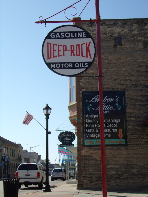
For old service station fans, you can see an old Deep Rock gas station in downtown Algoma. Deep Rock was a chain of service stations in the Midwestern United States. I'm not sure if the service station is in use anymore.
|
 |
Another look at Crescent Beach along the blue Lake Michigan water.
|
 |
Ducks join me for a final look at the lighthouse. We are beginning to say our goodbye to Algoma.
|
 |
Algoma also has a bunch of historic murals that have been painted on the buildings around downtown. I'm not sure this is it though.
|
 |
Starting to leave Algoma and we get warned about some construction up ahead in Kewaunee.
|
 |
If you want a different adventure, you can turn right here at WIS 54, which is a highway that crosses Wisconsin, passing by Green Bay, Wisconsin Rapids, Black River Falls and an orange moose on its way to the Mississippi River and Winona, Minnesota.
|
 |
Back to roads... back to the farms and silos...
|
 |
You didn't think you'd be driving through Alaska on this trip, did you?
|
 |
Approaching Kewaunee. During the 17th Century, early French explorers like Jean Nicolet and priests like Father Jacques Marquette visited what is now Kewaunee. The city was first settled and plotted in 1836 and once had dreams of exceeding Chicago in importance.
|
 |
WIS 29 is another cross-state highway, going through Green Bay, Wausau and Chippewa Falls on its way to the Mississippi River. WIS 29 is a major highway through much of its length, but starts off as a dandy two lane road as it starts its westward journey in Kewaunee.
|
 |
Snug Harbor. Looks like it was a boathouse in Kewaunee's harbor. At one time, there used to be a car ferry slip in Kewaunee, as Kewaunee was a landing site for one of many ferries that crossed Lake Michigan. Ferries stopped running to Kewaunee in 1990.
|
 |
The Tug Ludington as it rests in Kewaunee's harbor. This boat was used during the D-Day invasion of Normandy during World War II, but spend most of its time in service to assist with the construction and maintenance of harbors in the Great Lakes. The boat is open for tours as well.
|
 |
Looking at Lake Michigan and the Kewaunee Pierhead Lighthouse.
|
 |
Kewaunee County Court House.
|
 |
Starting to make our way south on WIS 42.
|
 |
Kewaunee is just north of the halfway point of our tour on WIS 42.
|
 |
Farms. After all, we are in America's Dairyland.
|
 |
I've had enough farm history for now. Let's go back on the road.
|
 |
Turn left to remain on WIS 42, but if you choose to remain in Two Rivers, there is plenty to see, do and eat. It is nicknamed the Cool City for a reason, well multiple reasons if you include the cool breezes that come off of Lake Michigan.
|
 |
Traveling along the four lane highway between Two Rivers and Manitowoc. It was a perfect day for a Wisconsin cruise along Lake Michigan.
|
 |
On the border of Two Rivers is an interesting sculpture. I just happened to visit it a few days before it was officially dedicated.
|
 |
Spirit of the Rivers sculpture, which was erected in July 2018 along the Mariners Trail, which is a sculpture and walking trail between Two Rivers and Manitowoc.
|
 |
Hug yourself and buckle up!
|
 |
Entering Manitowoc and still on the Lake Michigan Circle Tour. Manitowoc is a city that built its reputation on shipbuilding and brewing, plus there is plenty to see and do there. You may know about Manitowoc for the Manitowoc Minute sketches by famed comedian Charlie Berens. But did you know that even the Sputnik visited Manitowoc (well, a piece of the Sputnik).
|
 |
Fresh off its journey across Lake Michigan on the SS Badger from Ludington, Michigan, US 10 will join WIS 42 for a bit.
|
 |
Just a pleasant drive along the residential stretches of Manitowoc.
|
 |
| Wayfinding. |
 |
Getting close to ending our journey at I-43. US 10 goes right and then heads to Appleton, which WIS 42 turns left and eventually makes its way to Sheboygan.
|
How to Get There:
Sources and Links:
The State Trunk Tour - 42: Sheboygan to the Door Tip
ScenicHwy42.com - Scenic HWY 42
Green Bay Press-Gazette - Kewaunee, Algoma, Manitowoc groups team to highlight scenic Lake Michigan drive


Comments