
California State Route 905 is a 8.964 mile freeway presently aligned from Tocayo Avenue in the City of San Diego to the Mexican Border at Otay Mesa. California State Route 905 is known as the Otay Mesa Freeway and was approved during 1984 to become Interstate 905 upon being completed to Interstate standards. Presently California State Route 905 has a unbuilt segment west from Interstate 5 to the Mexican Border near Border Field State Park.

Part 1; the history of California State Route 905
What is now California State Route 905 ("CA 905") conceptually was brought into the State Highway System as Legislative Route Number 281 ("LRN 281"). LRN 281 was added to the State Highway System as part of 1959 Legislative Chapter 1062 with the following definition:
"[LRN 2] near the south end of San Diego Bay to east of the United States Naval Auxiliary Air Station, Brown Field"
Thusly the planned corridor of LRN 281 appears for the first time on the 1960 Division of Highways Map.

1963 Legislative Chapter 1698 changed the definition of LRN 281 to have an eastern terminus at LRN 282. LRN 281 was subsequently reassigned as segment (A) of CA 75 during the 1964 California State Highway Renumbering. The extended definition of CA 75 with it's planned eastern terminus at CA 125 appears for the first time on the 1964 Division of Highways Map.

The adoption of 9.7 freeway miles of CA 75 between Interstate 5 and CA 125 was announced in the July/August 1965 California Highways & Public Works. The CA 75 freeway followed the general corridor of Otay Mesa Road and Harvest Road from Interstate 5 towards to planned CA 125. According to CAhighways.org the adoption of the freeway corridor of CA 75 between Interstate 5 and CA 125 was made by the California Highway Commission on June 29th, 1965.

Thusly the adopted freeway alignment of CA 75 east of Interstate 5 first appears on the 1966 Division of Highways Map.

According to CAhighways.org the Division of Highways and San Diego County entered into a freeway agreement on January 2nd, 1969 to construct CA 75 from Interstate 5 to CA 125. 1972 Legislative Chapter 1216 created the second designation of CA 117 with the following definition:
"The international boundary near Borderfield northeasterly to Route 5"
The new designation of CA 117 can be seen for the first time on the 1975 Caltrans Map terminating at Interstate 5 and the planned CA 75 freeway.

1976 Legislative Chapter 1354 transferred segment (A) of CA 75 and consolidated it into CA 117. The consolidated CA 117 appears for the first time on the 1977 Caltrans Map. CA 117 is shown to be constructed east from Interstate 5 and Interstate 805.

According to CAhighways.org the California Transportation Commission adopted a routing for CA 117 the Otay Mesa Port of Entry west to Harvest Road on March 24th, 1983. This measure by proxy truncated unbuilt CA 125 from the Mexican Border to CA 117. The extended definition of CA 117 appears on the 1986 Caltrans Map.

The entire corridor of CA 117 was approved by the Federal Highway Administration during October 1984 as non-chargeable Interstate 905. The designation of Intestate 905 was contingent upon CA 117 being fully brought up to Interstate standards. The Otay Mesa Border Port of Entry opened January 24th, 1985. 1986 Legislative Chapter 928 transferred the entirety of CA 117 to the newly designated CA 905. CA 905 along with a new freeway facility from CA 125 to the Otay Mesa Port of Entry appear on the 1988 Caltrans Map. Caltrans would not assume maintenance of the segment of freeway from CA 125 to the Otay Mesa Port of Entry until July 1st, 1990 according to CAhighways.org.
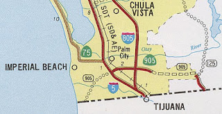
On October 28th, 2004 the California Transportation Commission adopted a planned freeway segment which would close the gap in the completed segments of CA 905 between Interstate 805 and CA 125. CA 905 between Interstate 805 and CA 125 was completed/opened to traffic during late 2012. Despite being completed east of Intestate 5 to the Otay Mesa Port of Entry there has not been any movement towards signing CA 905 as Interstate 905. There is presently no active plans to construct CA 905 west from Interstate 5 to the Mexican Border.
Part 2; Roadwaywiz on California State Route 905
On April 18th, 2020 the Roadwaywiz Youtube Channel featured a brief on the history of California Sate Roue 905 during the San Diego area webinar. Panel members Dan Murphy, Tom Fearer and Scott Onson discuss CA 905 during time stamp 44:30-51:28.
Below the entirety of existing CA 905 eastbound can be viewed on the Roadwaywiz Youtube Channel:
Below the entirety of existing CA 905 westbound can be viewed on the Roadwaywiz Youtube Channel:
Comments