

Now settled in Cheyenne, it was time to do a series of day trips to explore various National Parks. First up, Rocky Mountain National Park.
Route: I-25 to US 34 and US 36 into the Park (pretty much the same way back)
Photo Set on Flickr: Rocky Mountain National Park

The best way I can describe Rocky Mountain National Park is that the park is like one large Bob Ross painting come to life. Or that it is endless Bob Ross paintings come to life. That's how much I enjoyed it. This blog entry is not much about the travel getting there; but about the park itself and the hikes that I did.
Going to RNMP in early November has both good points and bad points. First, it is not nearly as crowded, and you do not need to make park entry reservations. Also, if you are fortunate to go on a mild day, it can be very comfortable. Unfortunately, in November, many amenities are closed including Trail Ridge Road. I wasn't as worried about Trail Ridge Road as I wanted to take some time hiking.
The plan was to hike from Bear Lake to Emerald Lake - about four miles out and back. To do this, we entered the park at the Beaver Meadows Entrance Station and then followed Bear Lake Road to its end at the Bear Lake Trailhead. The drive along Bear Lake Road was very scenic and could easily be a blog entry on its own.
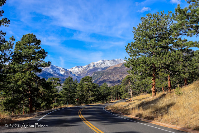 |
| Bear Lake Road - Rocky Mountain National Park |


Emerald Lake Hike:
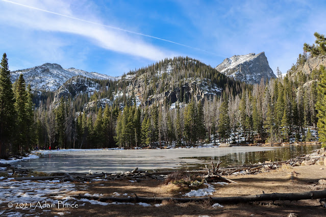
The Bear Lake trailhead parking lot wasn't too crowded when we got there. Bear Lake is immediately behind the trailhead to your right. For this hike - we'll check out four alpine lakes. (Bear, Nymph, Dream, and Emerald.)
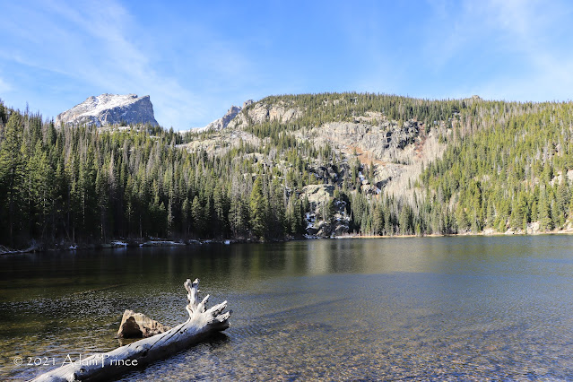 |
| Bear Lake - Rocky Mountain National Park |
The view of Longs Peak from the North Shore of Bear Lake is shown on the reverse side of the Colorado state quarter. I didn't capture my own photo from here. But there are so many great views around the lake that missing that opportunity did not matter. Throughout this hike, I was mesmerized by the 12,713' high Hallet Peak that constantly rose in front of me.


After taking photos at Bear Lake, I began the hike towards Emerald Lake. It's nearly two miles to Emerald Lake, and there's about a 700' elevation gain overall. It is about 0.7 miles from Bear Lake to the next lake - Nymph Lake. This hike has a steady elevation gain - and when you are an East Coaster like me - the altitude - around 9600' or so at this point - can get to you.
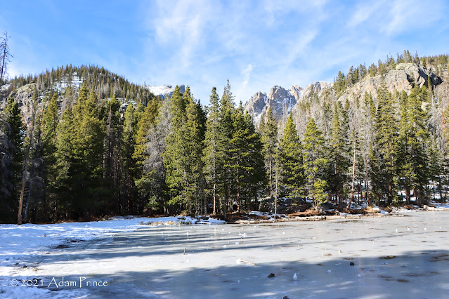 |
| Nymph Lake |
 |
| Hallett Peak (12,713') from Nymph Lake |
It is here at Nymph Lake - where I took some time to sit and rest - that the lure of this hike began. At every lake, I was drawn into the surroundings and its beauty even more. Just when I thought I had seen some of the best scenery of my life - there was more. It keeps you going. And on a nice day - it was sunny and at this elevation a brisk 38-45 degrees or so - you couldn't help but want to go further and see more.

 |
| A nearly frozen over Nymph Lake - Rocky Mountain National Park |
Nymph Lake was also where the transition of the lakes from unfrozen to frozen began. Bear Lake had very little, if any, ice. In contrast, Nymph Lake had started to freeze over for the winter. All four lakes are fed by the melting of the Tyndall Glacier that sits between Hallett Peak and Flattop Mountain.


The hike between Nymph and Dream Lakes offers great views, and the snowy surroundings make for a great backdrop. Along the hike, I ran into a trio of local retired ladies that hike this route often this time of year as they can enjoy it with fewer crowds. I also ran into a couple from Raleigh who were vacationing at RMNP after time in California. Both groups were very friendly, and in the case of the retired trio, were very helpful in pointers to navigate around some of the trickier icy spots ahead.

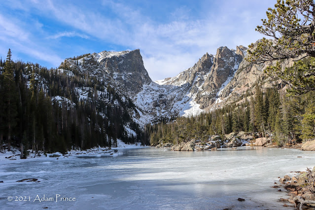 |
| Dream Lake - Rocky Mountain National Park |


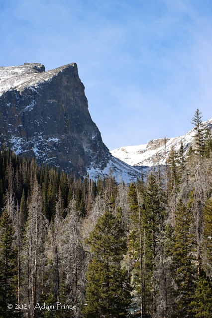
The beauty of Dream Lake, frozen over with snow-covered surroundings, fits its name. The views are truly amazing and breathtaking. I could have stopped the hike here and been more than happy. The trail goes along the east side of the lake; Hallett Peak and Flattop Mountain are majestic in this surrounding.
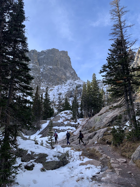 |
| Trekking towards Emerald Lake with Hallett Peak in the background. |
As I continued towards Emerald Lake, the altitude wasn't a problem. It was more how much time do I take on this hike to take photos; versus how much of this hike do I soak in. By this time, the elevation was now over 10,000 feet. Plus, the conditions were a little more treacherous. There were a few iced over inclines that were difficult to navigate. I didn't think of including or later purchasing chains/spikes to go over my hiking shoes. The elderly trio suggested that on the return hike - that I slide down the icy slope on my rear. So on the return, that's what I did.
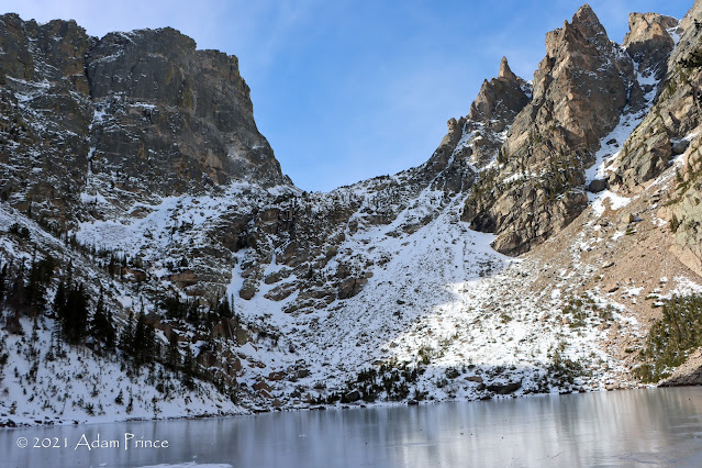 |
| Hallett Peak and the Flattop Mountains at Emerald Lake. |


But back to Emerald Lake. Fortunately, there wasn't much of any crowd. It was myself and the group of new friends I made on the way. Hallett Peak and Flattop Mountain, which dominated the backdrop of the entire hike, were pretty much in front of me. Again, this lake topped the views of the others. Reaching the final destination was calming - the chance to reflect on the beauty that was right in front of me and what I saw on the trek to Emerald Lake was relaxing and invigorating.
Of note, as I was preparing to head back, a few 20-somethings showed up. They had their Go Pro's and talked about their Instagram feeds. Later, while hiking back, I couldn't help but be amused by another 20-something videoing her hike on her phone as John Denver's "Rocky Mountain High" played. I then looked down at her shoes - they were sneakers with no traction. She most likely hit a "Rocky Mountain Bottom" when she got there.
I'm also glad that the plan to get to the trailhead early worked. The hike back had a lot more people hiking towards Emerald Lake.

This hike made me completely fall in love with Rocky Mountain National Park. If I had more time, I would have done a few more hikes from the trailhead to Alberta Falls or Haiyaha. But that'll be for another time, one that I hope I will be able to enjoy with my wife and two sons.
The enjoyment of RMNP didn't end there. I met back up with Joe at the trailhead parking lot, and we explored more of the park via car and overlooks.


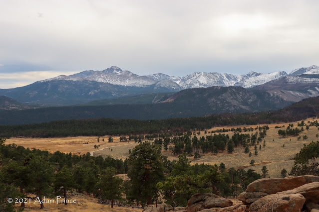 |
| Longs Peak towers over the valley below. |
 |
| US 34 East as you head out of the park. |

Though I only got to spend one day at Rocky Mountain National Park, I am so glad that I got to experience just a tiny slice of it. It is an amazing place and one I definitely will get back to.
Further Reading:
- Hike to Emerald Lake ---Rocky Mountain Hiking Trails
- Rocky Mountain National Park
2021 Wyoming Road Trip Site Navigation:
Photos without watermark - taken with post author's cell phone.
Comments