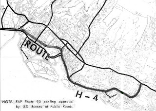
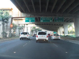
Hawaii Route 92 is a 9.3 mile State Highway located on the Island of O'ahu. Hawaii Route 92 connects Joint Base Pearl Harbor-Hickam east through downtown Honolulu via Nimitz Highway to Ala Moana Boulevard in Waikiki. Hawaii Route 92 is notable due to much of the highway being located underneath the Queen Liliuokalani Freeway portion of Interstate H-1. The Ala Moana Boulevard segment of Hawaii Route 92 was built largely over right of way which was originally set aside for proposed Interstate H-4.
This page is part of the Gribblenation O'ahu Highways page. All Gribblenation and Roadwaywiz media related to the highway system of O'ahu can be found at the link below:
https://www.gribblenation.org/p/gribblenation-oahu-highways-page.html
Part 1; the history of Hawaii Route 92
Prior to the Statehood the first signed highways within Hawaii Territory came into existence during World War II. During World War II the territory of Hawaii saw an influx of military activity following the attack on Pearl Harbor on December 7th, 1941. Numerous Military Routes and early Hawaii Routes were signed through the Hawaiian Territory to aid military personnel in navigating the islands. Military Highways were assigned US Route style shields whereas lesser highways were assigned an early variation of what is now the Hawaii Route Spade.
A 1946 Army Map of the Island of O'ahu shows modern Nimitz Highway as part of Hawaii Route 110 and Military Route 1 from Hickam Army Airfield to Honolulu. A full version of the 1946 Army Map of O'ahu can be seen on hawaiihighways.com here.
Circa 1955 following the conclusion of World War II the United States Bureau of Public Roads renumbered the Hawaii Route System. The 1955 Hawaii Route Renumbering saw most of the conventions utilized by the current Hawaii State Route System established. Primary Hawaii Routes were given two digit numbers whereas Secondary Hawaii Routes were given three digit numbers. The Hawaii Routes were assigned in sequence for what Island/County they were located on coupled with what Federal Aid Program number they were tied to. In the case of O'ahu the Island was assigned numbers in the range of 60-99. In the case of Nimitz Highway it was assigned as Hawaii Route 92.
Hawaii Route 92 on Nimitz Highway can be seen constructed to Hawaii Route 61 at Nuuanu Boulevard in downtown Honolulu on the 1959 Gousha Map of Hawaii. Ala Moana Boulevard is shown with no direct connection to Nimitz Highway.
According hawaiihighways.com what became Nimitz Highway had been planned as part of the cross-town Makai Arterial which would connect Honolulu to Hickam Army Airfield. The Makai Arterial was dropped during 1948 and the Mauka Arterial (future Intestate H-1) through Honolulu began to be developed instead.
On August 21st, 1959 Hawaii became the 50th State which saw it's profile rise significantly. The Interstate System in Hawaii was authorized as part of the 1960 Statehood Act. The 1960 Statehood Act authorized Interstates H-1, H-2 and H-3 on the Island of O'ahu. Hawaii Route 92 and Hawaii Route 90 from the outskirts of Hickam Airforce Base east to downtown Honolulu was selected to become part of the Queen Liliuokalani Freeway segment of Interstate H-1. Ultimately the corridor of Hawaii Route 90 would be deleted which left Hawaii Route 92/Nimitz Highway planned as being part of a surface highway underneath Interstate H-1/Queen Liliuokalani Freeway.
On August 24th, 1968 the Federal-Aid Highway Act of 1968 was signed into law by President Lyndon Johnson. The Federal-Aid Highway Act of 1968 added an additional 1,500 miles to the Interstate Highway System which was to be funded through 1972. The Federal-Aid Highway Act of 1968 was the impetus for numerous Interstate proposals which would include the concept of Interstate H-4. Interstate H-4 was presented as a proposed highway by way of a October 1968 Hawaii of Transportation Document titled; Proposed Route H-4.
Interstate H-1 on the Queen Liliuokalani Freeway from Exit 5 (HI 76/HI 750) to its western terminus opened during 1967. The Queen Liliuokalani segment of Interstate H-1 was completed east to Hawaii Route 78 (future Interstate H-201) by 1971. The completion of the Queen Liliuokalani Freeway saw the advent of the modern alignment of the Hawaii Route 92/Nimitz Highway underneath much of Interstate H-1. The Queen Liliuokalani segment of Interstate H-1 was gradually extended east of Hawaii Route 78 to the Lunalilo Freeway segment of Interstate H-1 culminating in the completion of the Intestate during May of 1986.
Part 2; Roadwaywiz on Hawaii Route 92
During May of 2019 Dan Murphy featured Hawaii Route 92 on the Roadwaywiz Youtube channel. Part 1 below features Hawaii Route 92 beginning at Kalakaua Avenue in Waikiki westward on Ala Moana Boulevard towards Nimitz Highway. Notably reassurance signage on much of Hawaii Route 92/Ala Moana Boulevard notes the highway directly accesses Daniel K. Inouye International Airport.
Part 2 features Hawaii Route 92 transitioning onto Nimitz Highway in downtown Honolulu and following westward underneath Interstate H-1/Queen Liliuokalani Freeway.
Part 3 features Hawaii Route 92 on Nimitz Highway underneath Interstate H-1/Queen Liliuokalani Freeway westward past Daniel K. Inouye International Airport towards the Hawaii Route 99/Kamehameha Highway junction towards Joint Base Pearl Harbor-Hickam.


Comments