

While the John Day Fossil Beds National Monument in eastern Oregon came to be in 1975, this attraction has been millions of years in the making. John Day Fossil Beds National Monument showcases one of the world’s best and most continuous records of fossilized plant and animal life of the Tertiary Period, the geologic time period during the Cenozoic Era from about 50 million years to 5 million years ago that is generally regarded as the Age of Mammals. The fossils found across the three units of the John Day Fossil Beds National Monument helped define the evolution of horses, cats, and other important mammal lineages.
The John Day Fossil Beds is a name that is generally applied to the Clarno, Painted Hills and Sheep Rock Units that make up the John Day Fossil Beds National Monument that totals about 25 square miles in Wheeler and Grant Counties, and more broadly, the more than 20,000 square miles of John Day Basin and adjacent lands that expose the fossil bearing strata from the Paleocene Age to the Miocene Age. The three units of the National Monument display changes in landscape, climate, and ecosystems through an important time in geologic history. The Clarno Unit, near the John Day River’s Clarno Bridge, includes vast volcanic debris flows and lahars that are 45 to 50 million years in age. Petrified leaves, trees and other plants which are now found as petrified remnants, record a subtropical ecosystem similar to that found in modern day Central America. Early ancestral bananas, figs, palms, and bald cypress flourished amid a volcanic landscape. Rainfall totaled about 80 inches per year at the time, and atmospheric carbon dioxide was much higher than today’s levels.
Located near Mitchell, Oregon, the Painted Hills Unit shows an illustration of the climate shift from tropical to temperate that occurred between 34 and 32 million years ago. Red bands of the Painted Hills were once tropical soils, while lighter colored bands are soils that developed at times of lower temperatures and less precipitation. Overall, as time progressed from 34 to 32 million years, the soils became lighter and the climate less tropical, and the Painted Hills shows show a sturdy record of the climate change of that era. The record at the Painted Hills culminates at the top of Carroll Rim, where soils and fossil plants and leaves indicate a temperate, grassy savannah with oaks and maples that prospered about 30 million years ago. The headquarters of the John Day Fossil Beds National Monument are located at the Sheep Rock Unit, near Dayville, Oregon. This area includes the Blue Basin, a renowned Oligocene fossil site, as well as Miocene era Picture Gorge basalts and strata of the Mascall Formation, which are about 14 million years old.
The fossils of the region were first discovered by soldiers who traveled The Dalles Military Road to the Canyon City area following the discovery of gold there in 1862. While guarding wagons of gold destined for ships on the Columbia River, the soldiers noticed fossils along the way. They brought the fossil discoveries to the attention of Reverend Thomas Condon, who was a Congregationalist minister in The Dalles as well as Oregon’s first state geologist and the first chair of the Geology Department at the University of Oregon. Condon recognized the importance of the fossils and joined the soldiers on their return to the fossil beds. It was here in a world of colorful eroded gullies and pinnacles that Condon found a stunning abundance of ancient life. In what is now the Blue Basin area of the Sheep Rock Unit, he found so many fossils that he named part of the valley The Cove. In the 1870s, other famed paleontologists mounted expeditions to the area to follow up on Condon's discoveries.
The different units that make up the John Day Fossil Beds National Monument are spread apart, and can take some time to properly explore. There are no campgrounds on the national monuments, plus facilities and towns are few and far between in the remote section of Oregon. But there are plenty of hiking trails which allow you to explore the vastness of the terrain and the beauty of the landscape. Where volcanoes and lava beds once made their home, the land has been eroded in places, making for some interesting views, whether you find fossils or not. The Thomas Condon Paleontology and Visitor Center along OR 19 in the Sheep Rock Unit of the national monument is good place to start as you explore this fascinating area.
 |
| Fossilized plant life on display at the Thomas Condon Paleontology and Visitors Center. When I visited the John Day Fossil Beds National Monument in October 2020, the visitors center was closed, but fortunately there were a few fossils on display outside. |
 |
| I want to say that this is the fossilized skull of a sabre-toothed cat. |
OR 19 connects the various points of interest along the Sheep Rock Unit of the John Day Fossil Beds National Monument. Part of the John Day Highway that connects the Columbia River and I-84 with the John Day River Basin, the most southernmost portion of OR 19 traverses through the national monument. OR 19 takes you through the Picture Gorge and past Cant Ranch, Blue Basin, Foree and the Thomas Condon Paleontology and Visitors Center.
 |
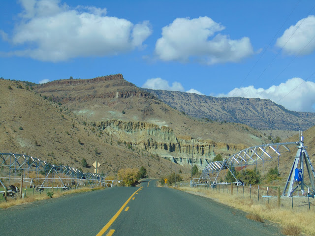
| It's about 121 miles on OR 19 from US 26 at Picture Gorge to I-84 in Arlington, Oregon. The pointed mountain that you see to your right is Sheep Rock, which reveals almost 25 million years of geologic record, from tropical volcanoes about 40 million years ago to 15 million year old basalt that cap the peak. |
 |
| After driving through Picture Gorge, the terrain starts to open up. |

 |
| The John Day River is to our right here. |


 |
| A few farms sprout up between the different sections of the Sheep Rock Unit along OR 19. |
 |
| Cathedral Rock is straight ahead. Cathedral Rock highlights a colorful greenish outcrop of the John Day Formation that is capped with reddish ignimbrite, formed by a combination of fast moving hot gas, ash, pumice and volcanic lava. |


The Cant Ranch Historic District is located in the Sheep Rock Unit of John Day Fossil Beds National Monument. The ranch showcases early 20th Century ranching operations in the John Day River Valley. In 1910, Scottish immigrants James and Elizabeth Cant purchased approximately 700 acres of land along the John Day River and started operating their ranch. Over time, land was added to the Cant property until it encompassed nearly 6,000 acres. The Cant Ranch was owned and operated by the Cant Family until 1975, when the Cant Ranch was sold by the family to the National Parks Service at the time the John Day Fossil Beds National Monument. Today, you can take a tour of the Cant Ranch home at certain times of the year and walk around the grounds around the home, with some interesting ranching equipment and Sheep Rock looming in the background.


The Blue Basin is a few miles north of the Cant Ranch and features some hiking trails, such as the Blue Basin Trail and the Island in Time Trail. The trails lead you to colorful banded badlands layers deposited between 28 and 31 million years ago and to the rim of the basin and rewards you with valley vistas.


A few miles north of the Blue Basin along OR 19 is the Foree trailhead, which also leads to a handful of trails to views of sculpted green claystone capped by volcanic flow and to rocks that contain fossils of creatures that lived here between 25 to 30 million years ago.


At the south end of the Picture Gorge, not far from US 26 is the Mascall Overlook. From this vantage point, you’ll see the Upper John Day Valley, the Strawberry Mountain Range, Picture Gorge, and the Mascall and Rattlesnake formations. The Mascall Formation is about 14 million years old, related to the time period of when the Cascades were being formed to the west.


Heralded as one of the Seven Wonders of Oregon, the Painted Hills Unit of the John Day Fossil Beds National Monument. Located west of the Sheep Rock Unit, the Painted Hills are located about 9 miles northwest of the town of Mitchell, along a road that leads from US 26.
At the Painted Hills, one can spend an entire day from dawn to dusk, photographing and hiking around the hills. Different weather and lighting conditions dramatically change the appearance of these stunning striped hills. Sunny days cause the soils to pop with a kaleidoscope of saturated colors, mainly of reddish and yellowish hues that are examples of ancient climate change. On overcast days, the undulating folds of these hills look like shadowy, rich, maroon and olive colored velvet. During wetter periods, the iron minerals oxidized and turned the soil red, while drier periods are represented by non oxidized yellowish colors. These wet and dry periods also accommodated different ecosystems. The road through the Painted Hills Unit is easily navigable gravel. There are five short trails within the Painted Hills, allowing you to see the various colors of the hills, along with trails that contain fossil sites.


How to Get There:
Sources and Links:
National Parks Services - John Day Fossil Beds National Monument
Oregon Encyclopedia - John Day Fossil Beds
Oregon Paleo Lands Center - Geology, Life and Climate
National Parks Traveler - 3 Days In John Day Fossil Beds National Monument
The American Southwest - John Day Fossil Beds National Monument
NPS eHistory - John Day Fossil Beds National Monument
My Itchy Travel Feet - Sifting Through History at John Day Fossil Beds National Monument
Oregon is For Adventure - The John Day Fossil Beds in Oregon—Painted Hills, Sheep Rock & Clarno
That Oregon Life - Peel Back Layers Of Time At Oregon’s John Day Fossil Beds Sheep Rock Unit
Comments