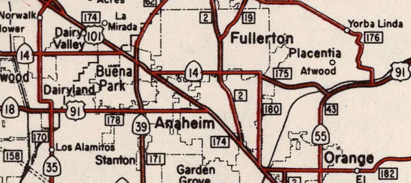
As originally defined California State Route 39 entered the community of Buena Park via Legislative Route Number 62 on La Mirada Avenue and transitioned southward on Legislative Route Number 171 via Grand Avenue. California State Route 39 southbound passed through the grounds of Knott's Berry Farm via Grand Avenue towards California State Route 18 at Lincoln Avenue. During the early 1940s California State Route 39 was moved to a bypass of Knott's Berry Farm via what is now Beach Boulevard. Above what was originally California State Route 39 on Grand Avenue at the Knott's Berry Farm entrance arch can be seen. Below California State Route 39 can be seen following Grand Avenue past Knott's Berry Farm on the 1938 Division of Highways Map City Insert.
Part 1; the history of California State Route 39 on Grand Avenue through Knott's Berry FarmLong before Knott's Berry Farm was a theme park it was a rural farm on the outskirts of Buena Park in western Orange County operated by Walter Knott. During the 1920s Knott and his family began to nurse abandoned berry plants back to health along Grand Avenue. The Knott's began to serve pies, berries and berry preserves along Grand Avenue during the latter part of the 1920s. In 1932 the Knott's began to introduce the Boysenberry after a visit Rudolph Boysen's farm in nearby Anaheim. The introduction the Boysenberry at Knott's Berry Farm was a hit which saw business at the pie stand along Grand Avenue begin to take off.
During 1933 the State Legislature removed the barriers preventing the Division of Highways from maintaining roads in incorporated as cities. This change led to a significant amount of highway mileage being added to the State inventory during 1933. Grand Avenue was added to the State Highway System as part of Legislative Route Number 171 (LRN 171) which was defined as:
"LRN 60 near Huntington Beach to LRN 2 (US Route 101) to Whittier"
The initial run of Sign State Routes were announced in the August 1934 California Highways & Public Works. California State Route 39 (CA 39) with the following definition:
The definition of CA 39 incorporated LRN 171 which took it past Knott's Berry Farm via Grand Avenue. At the time Knott's Berry Farm began selling Fired Chicken dinners along with Boysenberry Pie desserts. The notoriety of Knott's Berry Farm being located on early CA 39/Grand Avenue saw an influx of business. CA 39/LRN 171 on Grand Avenue at Knott's Berry Farm (insert 16) is shown to be a location of heavy traffic on the
1935 Division of Highways Map of Orange County. Grand Avenue presented an issue for CA 39 southbound traffic given it had to briefly multiplex CA 18/LRN 178 on Lincoln Avenue before continuing towards CA 3/LRN 60 via what was Stanton Avenue.

Below CA 39 can be seen following Grand Avenue past Knott's Berry Farm on the 1938 Division of Highways Map City Insert.
During late 1940 and early 1941 Knott's Berry Farm constructed the Main Street of the Ghost Town amusement park. The Ghost Town was designed by Paul von Klieben which modeled it off of the mining community of Calico located in the Mojave Desert. A contract to grade and surface a portion of CA 39/LRN 171 near Knott's Berry Farm is announced in the April 1941 California Highways & Public Works.
Subsequently CA 39/LRN 171 is shown to be realigned off of Grand Avenue on a bypass of Knott's Berry Farm via an extension of Stanton Avenue on the
1942 Division of Highways Map City Insert.

Not much changed with CA 39 in the vicinity of Buena Park and Knott's Berry Farm through the 1950s. The Ghost Town annex of Knott's Berry Farm was completed by the early 1950s. Walter Knott had purchased the ghost town of Calico in 1951 and put Paul von Klieben in charge of restoring it. Numerous attractions at Knott's Berry Farm opened during the 1950s as it transitioned more and more towards being a theme park.
The
1957 Division of Highways Map displays California State Route 18 and US Route 91 realigned onto the Stanton Avenue Extension along California State Route 39/LRN 171 in Buena Park. Both highways briefly multiplexed US Route 101 towards California State Route 14/LRN 175 on Orangethorpe Boulevard. California State Route 18 would be withdrawn from the multiplex beginning with the 1962 edition of the Division of Highways Map.
During the 1964 State Highway Renumbering the Legislative Route Numbers were dropped from the State Highway System. The 1964 Division of Highways State Map shows US Route 91/US Route 466 from Barstow to the Nevada State Line legislatively defined as part of Route 15. US Route 91 is shown truncated from Long Beach to Barstow. It is not clear when/if US Route 91 was approved for truncation to Barstow by the American Association of State Highway Officials Executive Committee.
Subsequent to US Route 91 being truncated to Barstow CA 39 again became the only highway aligned past Knott's Berry Farm via the Stanton Avenue Extension. In time CA 39 Buena Park would come to be known as Beach Boulevard, a designation it still carries.
Part 2; a drive on California State Route 39 and Grand Avenue to Knott's Berry Farm
Interstate 5 southbound on the Santa Ana Freeway approaches CA 39 via Exit 116 onto Beach Boulevard in Buena Park.
CA 39 follows Beach Boulevard south and intersects the Artesia Freeway segment of CA 91.
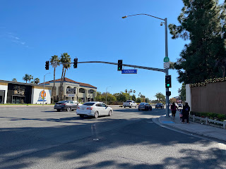
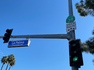
CA 39 southbound follows Beach Boulevard to La Palma Avenue at Postmile ORA 14.27 where touches the northeast boundary of Knott's Berry Farm.
An urban-style CA 39 reassurance shield can be viewed at the intersection of Beach Boulevard and La Palma Avenue.
Immediately south of La Palma Avenue CA 39 meets its original alignment at the now one-way Grand Avenue.
The Knott's Berry Farm entrance arch on Grand Avenue facing south on the original alignment of CA 39. Grand Avenue is now a one-way service road southward to Crescent Avenue.
Buena Park incorporated as a city on January 27th, 1953, and now includes the boundaries of Knott's Berry Farm. Given Gribblenation is a transportation page we won't go into intricate detail about the modern history or rides of Knott's Berry Farm. Knott's Berry Farm was sold ConAgra Incorporated in 1995 and was later purchased by Cedar Fair in 1997. The current shift in Knott's Berry Farm has seen a move towards thrill rides. Knott's Berry Farm had an attendance figure of approximately 4.1 million visitors in 2018.
Knott's Berry Farm notably is home to the attraction known as the Calico Railroad. Grading of the narrow-gauge Calico Railroad began in 1951 and attraction opened on January 12th, 1952. Below Denver & Rio Grand Western Railroad #340 ("the Green River") can be seen awaiting passengers on the Calico Railroad. The Green River is a C19 2-8-0 steam locomotive which was built by Baldwin Locomotive Works in 1881 for the Denver & Rio Grande Western Railroad. Knott's Berry Farm has numerous pieces of rolling stock which can be viewed for those less inclined for thrill rides.


Comments