
Lovers Leap State Park and Falls Bridge - New Milford, Connecticut


Located in New Milford, Connecticut, Lovers Leap State Park is a 160 acre state park. The name Lovers Leap is based on a legend that involves starcrossed lovers; an unidentified white man and Lillinoah, a Native American princess who was the daughter of Pootatuck Indian Chief Waramaug, that chose to leap to their deaths. The park has a number of walking paths and are split into three sections. There are the Old Factory Trails, the Waramaug Loop, and the Hurd Estate Trails found around the park. Each section of the park has their own sights to see, including a castle, ruins and overlooks of Lake Lilinonah.  The historic iron bridge over the Housatonic River is frequently the main attraction.

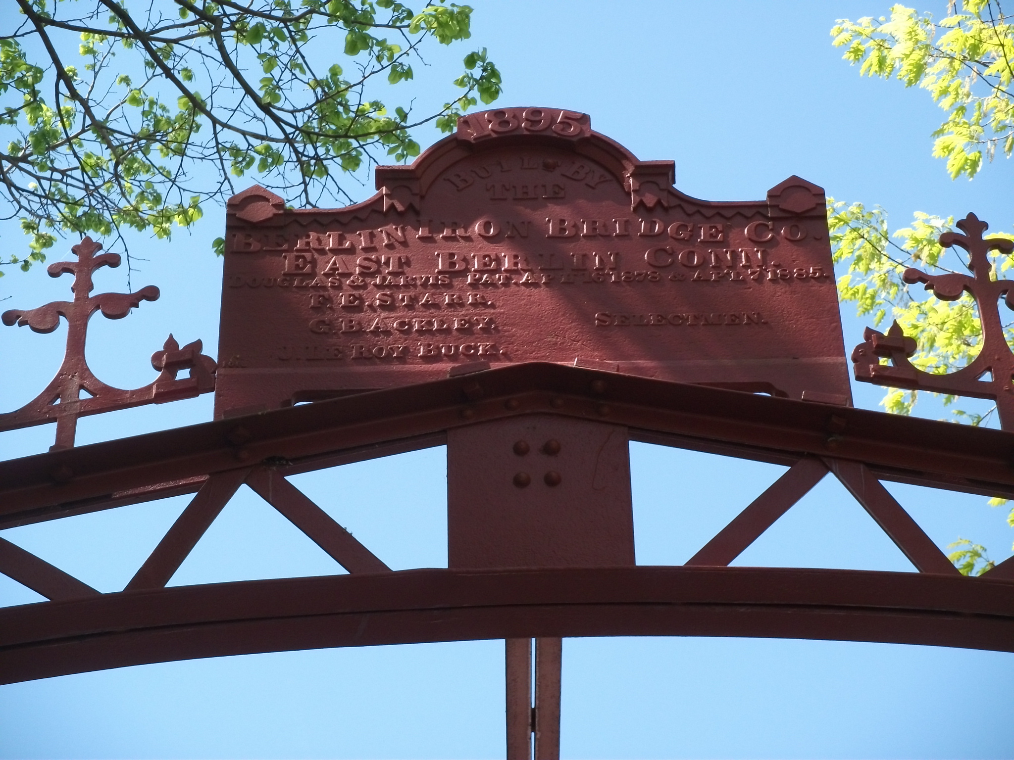
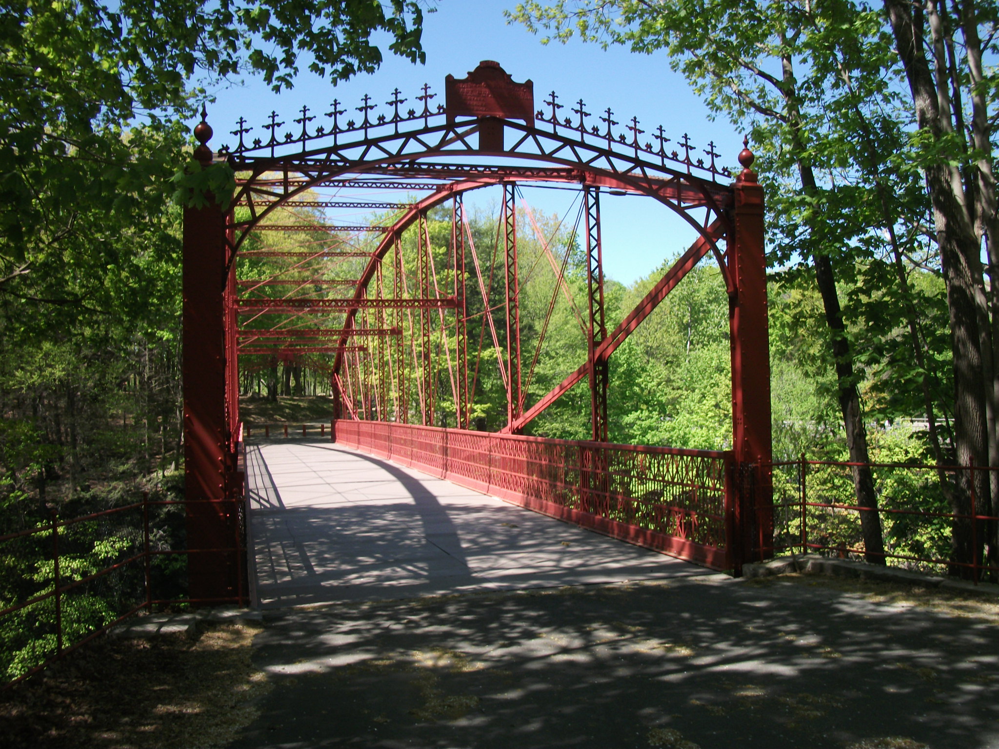
The Falls Bridge, which is an iron bridge built by the Berlin Iron Bridge Company of East Berlin, Connecticut, is a 173 foot lenticular truss bridge over the Housatonic River and was built in 1895. It is one of only a handful of iron truss bridges remaining in Connecticut. A similar bridge upstream on the Housatonic River called the Boardman Bridge was built a few years prior and local officials in New Milford were pleased by that bridge, so when a proposal to replace the Falls Bridge was made, they decided to go with a similar design. Once construction was completed, the bridge cost $7,938 to build. The bridge carried traffic until 1977. In 1994, efforts to restore the Falls Bridge begun, and after securing the $1.9 million in funding, restoration took place between 2004 and 2006, when the bridge reopened for pedestrian use.

Overall, Lovers Leap State Park is a pleasant place to visit and explore. The bridge is one of the focal points of the park and celebrates an era where there were once over 1,000 iron truss bridges crisscrossing the Constitution State. One of the other points of interest in the park is a rock formation with an overlook of Lake Lillinoah, where it is said that the princess and her lover leaped into the river below where they met their watery demise together.


How to Get There:


Sources and Links:
Damned Connecticut - Damned Hike: Lover’s Leap State Park, New Milford
Explore Connecticut - Lovers Leap State Park
CTMQ - TSTL’15.8: Lover’s Leap State Park
Connecticut Department of Energy and Environmental Protection - Lovers Leap State Park

Comments

Popular posts from this blog

Hawaii Route 8930

Hawaii Route 8930 is a 2.5-mile State Highway on the Island of O'hau.  Hawaii Route 8930 is aligned over Kualakai Parkway over the course of its entire alignment south from Interstate H-1 to Kapolei Parkway.  Hawaii Route 8930 is one of the newest Hawaii Routes only having been completed during 2010.   This page is part of the Gribblenation O'ahu Highways page.  All Gribblenation and Roadwaywiz media related to the highway system of O'ahu can be found at the link below: https://www.gribblenation.org/p/gribblenation-oahu-highways-page.html Part 1; the history of Hawaii Route 8930 The history of Hawaii Route 8930 is brief given it is a modern facility.  Hawaii Route 8930 and what was known as "North-South Road" were built to facilitate the developing areas of Kapolei on western O'ahu.  According to hawaiihighways.com the first stage of Hawaii Route 8930 was completed from Kapolei Parkway north to Farrington Highway as a four-lane highway during November...

Madera County Road 607 and the Stockton-Los Angeles Road

Madera County Road 607 is an approximately seven-mile rural unsurfaced highway which spans from Road 600 near Raymond west to Road 29.   Road 607 west from Raymond Road Cemetery (established in 1905) is part of the Stockton-Los Angeles Road corridor surveyed in 1853. The corridor lies in the gap between Fresno Crossing at the Fresno River west to Newton's Crossing at the Chowchilla River. The Buchanan Copper Mine would be along what is now Road 607 in the namesake Buchanan Hollow during July 1863. The Buchanan Mine is thought to have once had a population of between 1,000-1,500 residents by the early 1870s. Copper prices would decline in the decade after the Civil War and much of the activity at Buchanan shifted towards cattle ranching. The last businesses in the community would shutter during World War II and it is now a true ghost town. Part 1; the history of Madera County Road 607 and the Stockton-Los Angeles Road What is now Road 607 was a component of the larger Sto...

Old US Route 60/70 through Hell (Chuckwall Valley Road and Ragsdale Road)

Back in 2016 I explored some of the derelict roadways of the Sonoran Desert of Riverside County which were part of US Route 60/70; Chuckwalla Valley Road and Ragsdale Road. US 60 and US 70 were not part of the original run of US Routes in California.  According to USends.com US 60 was extended into California by 1932.  US 60 doesn't appear on the California State Highway Map until the 1934 edition. USends.com on US 60 endpoints 1934 State Highway Map Conversely US 70 was extended into California by 1934, it first appears on the 1936 State Highway Map. USends.com on US 70 endpoints 1936 State Highway Map When US 60 and US 70 were extended into California they both utilized what was Legislative Route Number 64 from the Arizona State Line west to Coachella Valley.  LRN 64 was part of the 1919 Third State Highway Bond Act routes.  The original definition of LRN 64 routed between Mecca in Blythe and wasn't extended to the Arizona State Line until 1931 acc...