
Phase 1 of the California State Route 132 West Expressway (in the making since 1947)

On September 15, 2022, the Phase 1 of the California State Route 132 West Expressway opened in the city of Modesto from California State Route 99 west to North Dakota Avenue.  Phase 1 of the California State Route 132 West Expressway was built upon a corridor which was tentatively to designated to become the branching point for Interstate 5W in the 1947 concept of the Interstate Highway System.  The present California State Route 132 West Expressway corridor was adopted by the California Highway Commission on June 20, 1956.  Despite almost being rescinded during the 1970s the concept of the California State Route 132 West Expressway corridor lingered on for over half a century and became likely the oldest undeveloped right-of-way owned by California Transportation Commission.  Pictured above is the planned California State Route 132 freeway west of US Route 99 in Modesto as featured in the May/June 1962 California Highways & Public Works.  


Part 1; the history of the California State Route 132 West Expressway corridor

What is now the California State Route 132 West Expressway corridor was tentatively approved as part of the original 1947 concept of the Interstate Highway System as the branching point of Interstate 5W.  Interstate 5W would have branched from mainline Interstate 5 in Modesto and followed the corridor of California State Route 132/Legislative Route Number 110 west to California State Route 33.  Interstate 5 would have followed US Route 99 into Modesto north from the Merced area and Interstate 5E would have followed US Route 99 north from Modesto towards Sacramento.  The 1947 concept of the Interstate Highway System was never approved on the Federal Level.  

On June 20, 1956, the California Commission adopted a freeway routing for California State Route 132/Legislative Route Number 110 from US Route 99 in Modesto westward to the San Joaquin River.  The adopted alignment of the California State Route 132 freeway west of US Route 99 was located immediately south of Kansas Avenue. 

On June 29, 1956, the Federal Highway Aid Act of 1956 was signed into law on the Federal Level.  The Federal Highway Aid Act of 1956 was the genesis point of the modern Interstate Highway System.  Unlike the original 1947 concept of the Interstate System the corridor of Interstate 5 was not planned to follow US Route 99 in San Joaquin Valley.  The Westside Freeway corridor of Legislative Route Number 238 was defined by 1957 Legislative Chapter 26 as the alignment of Interstate 5 in San Joaquin Valley.  

During 1958 the California Highway Commission proceeded with the purchase of right-of-way for the California State Route 132/Legislative Route Number corridor from Dakota Avenue west to Gates Road.  The planned freeway corridor of California State Route 132/Legislative Route Number 110 west from US Route 99 to the San Joaquin River can be seen on a Division of Highways District X report featured in the July/August 1959 California Highways & Public Works.  The freeway corridor of California State Route 132 west of US Route 99 to the San Joaquin River is shown to be under a freeway agreement. 


The May/June 1962 California Highways & Public Works displays the adopted alignment of California State Route 132/Legislative Route 110 west of the planned US Route 99/Legislative Route Number 4 freeway in Modesto.  


The September/October 1963 California Highways & Public Works featured an update to the US Route 99/Legislative Route Number 4 freeway in Modesto.  The article stub references a planned interchange with the western California State Route 132/Legislative Route Number 110 freeway near Kansas Avenue.  


As part of the 1964 State Highway Renumbering the Legislative Route Numbers were dropped in favor of field signage or new Sign State Route designations.  Thusly Legislative Route Number 110 was simply reassigned as the field signed California State Route 132.  

The September/October 1965 California Highways & Public Works discusses the opening of the Modesto Freeway alignment of US Route 99.  The Modesto Freeway was opened to traffic on June 30th, 1965.  The US Route 99 freeway is noted to have an interchange with Kansas Avenue but noted the freeway-to-freeway connection with the planned California State Route 132 west of Modesto would be constructed a later date.  Note: US Route 99 had been truncated to Ashland, Oregon by the American Association of State Highway Officials during June 1965 and it would be replaced by California State Route 99 beginning during 1966. 


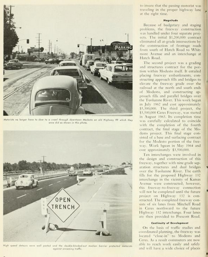
Through the late 1960s most of the remaining right-of-way for the California State Route 132 freeway west of US Route 99/California State Route 99 in Modesto had been obtained by the California Highway Commission.  During 1975 the California Highway Commission filed a Notice to Rescind the California State Route 132 freeway adoption west of Modesto.  During 1976 the California Highway Commission conditionally retained the California State Route 132 freeway adoption contingent upon a cooperative agreement with the city of Modesto and Stanislaus County to assume responsibility for hardship and protection of the right-of-way acquired until construction funds became available.  The California Highway Commission, Stanislaus County and Modest signed a cooperative agreement to retain the adopted freeway corridor of California State Route 132 on March 1, 1977. 

The adopted freeway corridor of California State Route 132 from California State Route 99 west to San Joaquin River appears on the 1979 Caltrans Map.  


TCRP Project #109 was cited in the May 2002 California Transportation Commission agenda as an improvement to California State Route 132 west from California State Route 99 paralleling Kansas Avenue.  The 2005 Transportation Bill included $14.4 million to widen California State Route 132 west of California State Route 99 to Dakota Avenue.  By May 2012 the California Transportation Commision identified a preferred alternative for the proposed new alignment of California State Route 132 west from California State Route to North Dakota Avenue.  The general preferred alternative corridor of California State Route 132 between California State Route 99-North Dakota Avenue can be seen on the project map issued during 2014.


During May 2018, the California Transportation Commission accepted an Environmental Impact Report for the California State Route 132 West Expressway corridor between California State Route 99-North Dakota Avenue.  During June 2019, the California Transportation Commission approved the temporary route adoption of North Dakota Avenue (Postmiles T11.4-11.9) as conventional highway to connect existing California State Route 132 along Maze Boulevard to Phase 1 of the California State Route 132 West Expressway.  


Construction of Phase 1 of the California State Route 132 West Expressway from California State Route 99 west to North Dakota Avenue began during November 2019.  Below the new interchange to Phase 1 of the California State Route 132 West Expressway can be seen along California State Route 99 during April 2021. 


Below the interchange to Phase 1 of the California State Route West Expressway can be seen along California State Route 99 during August 2021.  


On September 15, 2022, the Phase 1 of the California State Route 132 West Expressway opened in the city of Modesto from California State Route 99 west to North Dakota Avenue.  Below the dedication ceremony of Phase 1 of the California State Route 132 West Expressway can be seen as was featured on the Caltrans District 10 Facebook Page.  

The California State Route 132 West Expressway is planned to reach Paradise Avenue via Phase 2 of the corridor by 2027.   Pictured below, the four California State Route 132 West Expressway Phase 2 corridor alternatives west from Dakota Avenue west to Paradise Road can be observed.  


Part 2; a drive on the California State Route 132 West Expressway

Traffic following westbound California State Route 132 is required to use a ramp from 6th Street to reach the West Expressway at a traffic light.  Presently the new freeway corridor only directly connects to California State Route 99 via an eastbound-to-southbound ramp movement.  


The California State Route 132 West Expressway continues as a Super Two freeway to Dakota Avenue.  The highway takes a brief temporary jog on Dakota Avenue to reaching the existing surface highway at Maze Boulevard.  


Comments

Popular posts from this blog

Hawaii Route 8930

Hawaii Route 8930 is a 2.5-mile State Highway on the Island of O'hau.  Hawaii Route 8930 is aligned over Kualakai Parkway over the course of its entire alignment south from Interstate H-1 to Kapolei Parkway.  Hawaii Route 8930 is one of the newest Hawaii Routes only having been completed during 2010.   This page is part of the Gribblenation O'ahu Highways page.  All Gribblenation and Roadwaywiz media related to the highway system of O'ahu can be found at the link below: https://www.gribblenation.org/p/gribblenation-oahu-highways-page.html Part 1; the history of Hawaii Route 8930 The history of Hawaii Route 8930 is brief given it is a modern facility.  Hawaii Route 8930 and what was known as "North-South Road" were built to facilitate the developing areas of Kapolei on western O'ahu.  According to hawaiihighways.com the first stage of Hawaii Route 8930 was completed from Kapolei Parkway north to Farrington Highway as a four-lane highway during November...

Madera County Road 607 and the Stockton-Los Angeles Road

Madera County Road 607 is an approximately seven-mile rural unsurfaced highway which spans from Road 600 near Raymond west to Road 29.   Road 607 west from Raymond Road Cemetery (established in 1905) is part of the Stockton-Los Angeles Road corridor surveyed in 1853. The corridor lies in the gap between Fresno Crossing at the Fresno River west to Newton's Crossing at the Chowchilla River. The Buchanan Copper Mine would be along what is now Road 607 in the namesake Buchanan Hollow during July 1863. The Buchanan Mine is thought to have once had a population of between 1,000-1,500 residents by the early 1870s. Copper prices would decline in the decade after the Civil War and much of the activity at Buchanan shifted towards cattle ranching. The last businesses in the community would shutter during World War II and it is now a true ghost town. Part 1; the history of Madera County Road 607 and the Stockton-Los Angeles Road What is now Road 607 was a component of the larger Sto...

Old US Route 60/70 through Hell (Chuckwall Valley Road and Ragsdale Road)

Back in 2016 I explored some of the derelict roadways of the Sonoran Desert of Riverside County which were part of US Route 60/70; Chuckwalla Valley Road and Ragsdale Road. US 60 and US 70 were not part of the original run of US Routes in California.  According to USends.com US 60 was extended into California by 1932.  US 60 doesn't appear on the California State Highway Map until the 1934 edition. USends.com on US 60 endpoints 1934 State Highway Map Conversely US 70 was extended into California by 1934, it first appears on the 1936 State Highway Map. USends.com on US 70 endpoints 1936 State Highway Map When US 60 and US 70 were extended into California they both utilized what was Legislative Route Number 64 from the Arizona State Line west to Coachella Valley.  LRN 64 was part of the 1919 Third State Highway Bond Act routes.  The original definition of LRN 64 routed between Mecca in Blythe and wasn't extended to the Arizona State Line until 1931 acc...