
Hawaii Route 3400 (the amalgamation of former Hawaii Route 34 and former Maui County Route 341)


Hawaii Route 3400 is a 2.6-mile State Highway located on the Island of Maui in the Wailuku and Kahului areas.  Hawaii Route 3400 is comprised of portions which were once part of Hawaii Route 34 on Kahului Beach Road and Maui County Route 341 on Waiehu Beach Road.  Modern Hawaii Route 3400 now bridges Hawaii Route 32 at Kaahumanu Avenue in Kahului north to Hawaii Route 340/Maui County 330 at Kahekili Highway near Wailuku. 


Part 1; the evolution of Hawaii Route 34 and Maui County Route 341 into Hawaii Route 3400

The Island of Maui seemingly was not part of the original World War II era Hawaii Route System.  Circa 1955 the United States Bureau of Public Roads renumbered the Hawaii Route System.  The 1955 Hawaii Route Renumbering saw most of the conventions utilized by the current Hawaii State Route System established.  Primary Hawaii Routes were given two-digit numbers whereas Secondary Hawaii Routes were given three-digit numbers.  The Hawaii Routes were assigned in sequence for what Island/County they were located on coupled with what Federal Aid Program number they were tied to.  In the case of the Island of Maui it was assigned numbers in the range of 30-40.  

Hawaii Route 34 was aligned from Hawaii Route 32 at Kaahumanu Avenue in Kahului west through Wailuku on a partially completed downtown bypass via lower Main Street and approximately half a mile of Waiale Road.  Hawaii Route 34 was connected to Hawaii Route 30 south of downtown Wailuku via non-state-maintained Koa Drive.  Maui County Route 341 was aligned north from Hawaii Route 34 at lower Main Street via what is now Waiehu Beach Road and Lower Waiehu Beach Road to Waiehu Beach Park.  The original configurations of Hawaii Route 34 and Maui County Route 341 can be seen on the 1955 United States Geological Survey map of Wailuku.  

According hawaiihighways.com a 1967 Hawaii Department of Transportation document recommended the removal of Hawaii Route 34 from the Federal-Aid Highway System and by proxy State Highway System.  This measure seems to have been taken due to Koa Drive never been taken on as a State maintained facility which meant Hawaii Route 34 never fully functioned as the bypass of downtown Wailuku it was intended to be.  

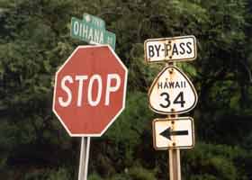
Despite being a mainline State Highway, it appears Hawaii Route 34 may have been always signed with "bypass" placards.  A 2001 era image of a Hawaii Route 34 shield along with a bypass placard can be seen on hawaiihighways.com here.  

1.5 miles of Maui County Route 341 (Waiehu Beach Road) from lower Main Street to Waiehu Stream and 4.3 miles of Kahekili Highway north of Waiehu Stream were to Camp Maluhia were recommended to be added to the State Highway System.  This led to construction of a new connecting branch of Waiehu Beach Road directly to Kahekili Highway.  This new construction led to the designation of Hawaii Route 340 which followed Kahului Beach Road (formerly lower Main Street) 1.1 miles, Waiehu Beach Road for 1.5 miles and replacing Hawaii Route 33 over Kahekili Highway for 4.3 miles.  Hawaii Route 340 can be seen on the 1983 United States Geological Survey Map of the Wailuku area.  


It is unclear when Hawaii Route 3400 replaced Hawaii Route 340 between Kaahumanu Avenue and Kahekili Highway.  Hawaii Route 3400 is shown to be interchange with Hawaii Route 340 on the 2017 United State Geological Survey map of the Wailuku area.  Hawaii Route 340 shields strangely are occasionally in place along modern Hawaii Route 3400.  


Part 2; a drive on Hawaii Route 3400

Hawaii Route 3400 begins via a right-hand turn from the terminus of Maui County Route 330 on Kahekili Highway onto Waiehu Beach Road.  


Hawaii Route 3400/Waiehu Beach Road eastbound intersects former Maui County Route 341 at Lower Waiehu Beach Road.  

Hawaii Route 3400/Waiehu Beach Road continue east to Kahului Beach Road and lower Main Street.  Hawaii Route 3400 makes a left hand turn onto Kahului Beach Road whereas Hawaii Route 34 would have once gone in both directions.  For unknown reasons the approach to Kahului Beach Road and lower Main Street is signed "junction Hawaii Route 340."


Hawaii Route 3400 continues east via Kahului Beach Road where it terminates at Hawaii Route 32/Kaahumanu Avenue (GSV image used).


Comments

Popular posts from this blog

Former US Route 50 and the Pioneer Route Lincoln Highway on Johnson's Pass Road

Johnson's Pass Road is one of the oldest highway corridors in California.  Johnson's Pass was part of the Lake Tahoe Wagon Road as it was completed during 1856 over the Sierra Nevada.  The pass would later be incorporated into the Pioneer Branch of the Lincoln Highway in 1913 and US Route 50 in 1926.  Johnson's Pass Road would be bypassed by a new alignment of US Route 50 over Echo Summit in 1938.  A replacement of the Meyers Grade east of Johnson's Pass would be opened to traffic in 1947.   Johnson's Pass Road remains accessible to traffic and is still signed by the Lincoln Highway Association.  Pictured as the blog cover is the view from the top of Johnson's Pass Road overlooking modern US Route 50 and Lake Tahoe.   Part 1; the history of Johnson's Pass Much of the history of what become the Lake Tahoe Wagon Road is discussed in the  September 1950 California Highways & Public Works  during its Centennial Edition.  The or...

Former US Route 50 and the South Lincoln Highway from Folsom east to Placerville

The corridor of Folsom of Sacramento County east to Placerville of El Dorado County has been a long established corridor of overland travel dating back to the California Gold Rush.  The Folsom-Placerville corridor was once part of the path of the Lake Tahoe Wagon Road which became the first California State Highway and later the South Lincoln Highway.  In time the South Lincoln Highway's surface alignment was inherited by US Route 50.  The Folsom-Placerville corridor also includes the communities of; Clarksville, Shingle Springs and El Dorado. Part 1; the history of the Lake Tahoe Wagon Road, South Lincoln Highway and US Route 50 through Folsom-Placerville Folsom is located on the American River/Lake Natoma of eastern Sacramento County.  That lands now occupied by the City of Folsom were part of Rancho Rio de los Americanos prior to the finding of gold at Sutter's Mill during 1848.  During the California Gold Rush the lands of Rancho Rio de los Americanos were p...

Old NC 10 - The Central Highway: Old Fort to Black Mountain through the Royal Gorge

A unique way of tracing the remnants of the Central Highway is through the mountainous terrain of Eastern Buncombe and Western McDowell Counties.  From the east on US 70, you reach the base of Blue Ridge Mountains at the town of Old Fort.  Old Fort is a tiny rail town that the old Central Highway and now US 70 goes through.  The Central Highway can be followed via a right onto Mill Creek Road from US 70.  Follow the highway as it takes you closer to the mountains.  When Mill Creek Road bears right to head towards Andrews Geyser stay straight until the road ends at a gate.  The nearby Piney Grove Church can be used for parking.  At this point, the old Central Highway began a 3.5 mile climb of the mountain to Swannanoa Gap.  NC 10 and later US 70 travelers followed this road for over 30 years until a new and modern four lane US 70 was built to the south.  This same four lane road would eventually become Interstate 40.    The Centra...