
Vicksburg Mississippi River Bridges


Built nearly 45 years apart, the Mississippi River bridges in Vicksburg, MS are a great demonstration of how transportation and traffic changed dramatically in the United States during the 20th Century.


Opened in 1930, what is now known as the Old Vicksburg Bridge, was a missing link in the early American transportation network. Prior to the bridge's completion, all vehicle and rail traffic had to cross the Mississippi via ferry. The newly completed bridge solved that issue by having one rail line and an 18-foot roadway cross the mighty river.

The bridge, at the time the only Mississippi River bridge south of Memphis, would be a key connection for east-west travel in the South.


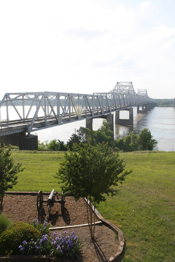
However, the bridge would quickly become outdated. At only 18 feet wide, the roadway was extremely difficult for trucks to navigate - and in later years the bridge would halt traffic to allow trucks to cross along with daytime-only crossings.

With the creation of the Interstate Highway System, the bridge would not be able to handle any of the modern freeway traffic. The new Vicksburg Bridge - located immediately downriver - opened in 1973. The new bridge carries four lanes of Interstate 20 and US 80 traffic on a 60-foot-wide highway.


The old Vicksburg Bridge didn't go away quietly. It continued to carry vehicular traffic until 1998. Freight trains still use the old Vicksburg Bridge to this day. The bridge will also 'open' occasionally for bike and pedestrian traffic for various festivals or race events.

All photos taken by post author - April 2010.

Further Reading:
How To Get There:

Comments

Popular posts from this blog

Trimmer Springs Road (Fresno County)

Trimmer Springs Road is an approximately forty-mile rural highway located in Fresno County.  The corridor begins near in California State Route 180 in Centerville and extends to Blackrock Road at the Kings River in the Sierra Nevada range near the Pacific Gas & Electric Company town of Balch Camp. The roadway is named after the former Trimmer Springs Resort and was originally constructed to facilitate access to the Sanger Log Flume.  Trimmer Springs Road was heavily modified and elongated after construction of Pine Flat Dam broke ground in 1947.   Part 1; the history of Trimmer Springs Road Much of the original alignment of Trimmer Springs Road was constructed to facilitate access to the Sanger Log Flume.   The  Kings River Lumber Company  had been established in 1888 in the form of a 30,000-acre purchase of forest lands in Converse Basin.  This purchase lied immediately west of Grant Grove and came to be known as "Millwood."  The co...

When was Ventura Avenue east of downtown Fresno renamed to Kings Canyon Road? (California State Route 180)

California State Route 180 was one of the original Sign State Routes designated in August 1934.  The highway east of Fresno originally utilized what was Ventura Avenue and Dunlap Road to reach what was then General Grant National Park.  By late year 1939 the highway was extended through the Kings River Canyon to Cedar Grove.   In 1940 General Grant National Park would be expanded and rebranded as Kings Canyon National Park.  The Kings Canyon Road designation first appeared in publications circa 1941 when the California State Route 180 bypass of Dunlap was completed.  Kings Canyon Road ultimately would replace the designation of Dunlap Road from Dunlap to Centerville and Ventura Avenue west to 1st Street in Fresno.   The Kings Canyon Road would remain largely intact until March 2023 when the Fresno Council designated Cesar Chavez Boulevard.  Cesar Chavez Boulevard was designated over a ten-mile corridor over what was Kings Canyon Road, remaini...

Interstate 99 at 30

When it comes to the entirety of the Interstate Highway System, Interstate 99, when fully completed, is nothing more than 161 miles of a roughly 48,000-mile system (0.3% of total length).  Yet, to more than just a handful of people, the number '99' rubs them the wrong way. Interstate 99 follows the path of two US Highway Routes - US 220 from the Pennsylvania Turnpike in Bedford north to Interstate 80 and then to US 15/Interstate 180 in Williamsport.  It then follows US 15 from Williamsport north to Interstate 86 in Corning, New York. Interstate 99 runs with US 220 through much of Central Pennsylvania. (Doug Kerr) US 220 from Cumberland, Maryland to Interstate 80 and US 15 north of Williamsport were designated part of the Appalachian Highway System in 1965.  Construction to upgrade both corridors progressed steadily but slowly.  In 1991, the two corridors were included as a National High Priority Corridor.  The route from Cumberland to Corning consisted of High P...