
Legislative Route Number 172 was a highway located in the Los Angeles area which was added to the State Highway System during 1933. Legislative Route Number 172 was initially intended to connect from Boyle Avenue in downtown Los Angeles east to Legislative Route Number 19 near Walnut Station. As originally conceived the planned routing of Legislative Route Number 172 would never be constructed from San Gabriel Boulevard east to Anaheim Puente Road. During the early 1950s through to the early 1960s the corridor was consolidated into the initial planned 30.6 miles of the Pomona Freeway. The Pomona Freeway between Los Angeles and Pomona in the lead up to the 1964 State Highway Renumbering was announced as a realignment of US Route 60. Following US Route 60 being truncated to Blythe during 1965 the Pomona Freeway would become part of California State Route 60.
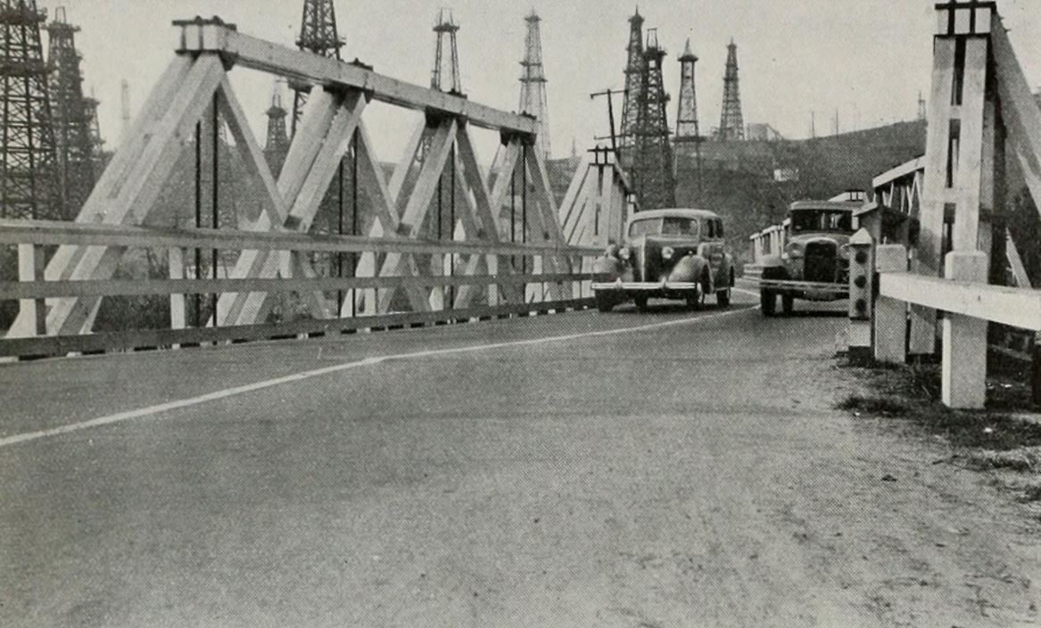
Legislative Route Number 172 can be seen as the blog cover crossing a timber truss bridge over the Rio Hondo River during 1938. Legislative Route Number 172 can be seen as below as it was displayed on the 1938 Division of Highways Map.

The history of Legislative Route Number 172
Legislative Route Number 172 (LRN 172) was added to the state highway system with the following definition:
"Los Angeles, Boyle Avenue, and 4th Street to LRN 19 near Walnut Station."
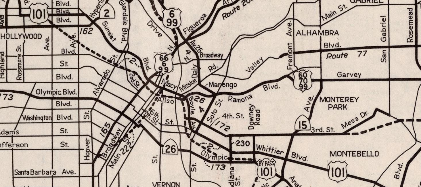
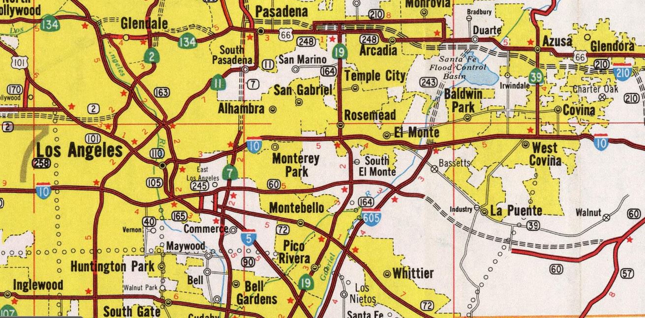
LRN 172 was not assigned one of the initial Sign State Route designations announced in the August 1934 California Highways & Public Works. LRN 172 can be seen for the first time on the 1934 Division of Highways Map. LRN 172 is shown originating at Boyle Avenue (US Route 101/LRN 2) in downtown Los Angeles. LRN 172 is shown departing east on 4th Street, 3rd Street and Pomona Boulevard towards an unconstructed segment through Montebello. A planned alignment through Puente is shown to connect to the eastern half of LRN 172 along 5th Avenue. The eastern half of LRN 172 is shown terminating at LRN 19 near Walnut Station and Pomona.

The 1935 Division of Highways Map of Los Angeles reveals more detailed information about the gap on LRN 172. The western half is shown to end at San Gabriel Boulevard (then California State Route 19/LRN 168) via 3rd Street, Pomona Boulevard, Mesa Drive (now Potrero Grande Drive) and Hill Drive.

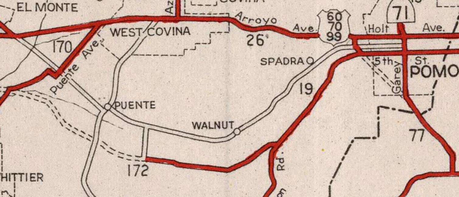
The eastern half of LRN 172 is shown to resume east of Anaheim Puente Road (now Azusa Avenue) along 5th Avenue (now Colima Road). LRN 172 is shown following what is now Golden Springs Drive and Brea Canyon Road to LRN 19 near Walnut Station.

The 1936-37 Division of Highways Map displays California State Route 19/LRN 168 realigned onto Rosemead Boulevard north of Montebello. The western half of LRN 172 is shown extended over the Rio Hondo Bridge via San Gabriel Boulevard.

The timber truss Rio Hondo Bridge on LRN 172 along San Gabriel Boulevard appears in the December 1938 California Highways & Public Works.

The western half of LRN 172 is shown truncated to the intersection of Hill Drive and San Gabriel Boulevard on the 1940 Division of Highways Map.

The same map depicts Anaheim Puente Road having been taken under state highway maintenance as part of the eastern segment of LRN 172.

The 1942 Division of Highways Map depicts Anaheim Puente Road as being withdrawn from the eastern half of LRN 172.
1947 Legislative Chapter 1233 changed the western origin of LRN 172 to LRN 2. This measure effectively extended LRN 172 west of Boyle Avenue via 4th Street to the planned Santa Ana Freeway (which can be seen on the 1948 Division of Highways Map).
The January/February 1956 California Highways & Public Works denoted LRN 172 as part of the larger Pomona Freeway corridor. An adoption of 18 miles of the Pomona Freeway between Potrero Grande Drive and LRN 19 was made by the California Highway Commission on April 2, 1954.

The adopted Pomona Freeway corridor east of Potrero Grande Drive appears on the 1958 Division of Highways Map. 1957 Legislative Chapter 1911 simplified the eastern terminus as simply "LRN 19."

The January/February 1959 California Highways & Public Works provided an update regarding the Pomona Freeway. The article notes the California Highway Commission defined the Pomona Freeway as running from the Santa Ana Freeway (US Route 101 and Interstate 5) in Los Angeles east to the Corona Freeway (California State Route 71) near Pomona on November 16, 1955. The California Highway Commision adopted the routing of the Pomona Freeway from the Santa Ana Freeway east to Woods Avenue on November 20, 1958. Additional Pomona Freeway alignment adoptions were made by the California Highway Commission on April 20, 1955, and June 21, 1955.


The January/February 1960 California Highways & Public Works announced the Pomona Freeway between Woods Avenue east to Potrero Grande Drive was adopted by the California Highway Commission on October 28, 1959.


The March/April 1961 California Highways & Public Works announced the California Highway Commission adopted a segment of the Pomona Freeway between LRN 19 at Brea Canyon east to the Corona Freeway on June 23, 1960. In total 30.6 miles of LRN 172 were adopted as future alignments of the Pomona Freeway.


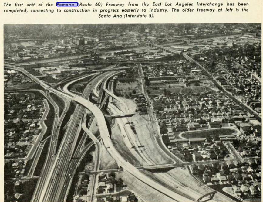
The March/April 1963 California Highways & Public Works noted the Pomona Freeway was planned as a realignment of US Route 60. The first unit of the Pomona Freeway was to be constructed from the East Los Angeles Interchange to 3rd Street near Downey Road.


As part of the 1964 State Highway Renumbering the Legislative Route Numbers were deleted in favor of field signage. What had been LRN 172, and the Pomona Freeway were consolidated into the new definition of US Route 60 (which did not include multiplexes). US Route 60 was defined in two segments:
(A) Route 10 near Soto Street in Los Angeles to Route 395 via Pomona and Riverside.
(B) Route 395 to Beaumont.
The new legislative definition of US Route 60 appears on the 1964 Division of Highways Map.

The March/April 1964 California Highways & Public Works noted the construction first unit of the Pomona Freeway was underway. The Pomona Freeway is noted to have an aggressive construction schedule which had a planned completion between Los Angeles and Pomona by 1970. The article notes the Pomona Freeway was planned as a realignment of US Route 60 eastward into the Riverside area.


The March/April 1965 California Highways & Public Works announced construction on the Pomona Freeway was either under construction or contracted via six project zones between East Los Angeles to Jellick Avenue. The East Los Angeles Interchange-3rd Street segment of the Pomona Freeway is noted to have an anticipated completion during Fall 1965.


The American Association of State Highways Officials Executive Committee approved US Route 60 to be truncated from downtown Los Angeles to US Route 95 in Blythe on October 2, 1965. The truncation of the US Route 60 spun the definition defined during the 1964 State Highway renumbering as California State Route 60.


The November/December 1965 California Highways & Public Works featured the recently completed East Los Angeles Interchange-3rd Street segment of the Pomona Freeway.
1968 Legislative Chapter 282 changed the western terminus of California State Route 60 "Route 10 near Los Angeles River in Los Angeles." The 1969 Division of Highways Map depicts the Pomona Freeway complete just east of Anaheim Puente Road. Anaheim Puente Road is shown to have been adopted as an interim routing of California State Route 60.

The 1970 Division of Highways Map depicts the Pomona Freeway under construction east through Pomona to California State Route 83 near Ontario.

The Pomona Freeway was completed through Pomona during the early 1970s and can be seen complete towards California State Route 83 on the 1975 Caltrans Map.

Comments