2024 First Day Road Trip

At around 10 am on New Year's Day, my wife says, "OK everyone - get dressed. We're going on a roadtrip. Oh, and wear warm clothes."
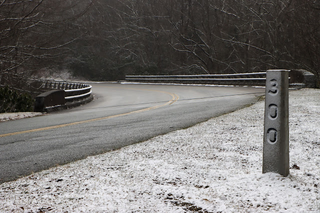
The dusting of snow as we drove along the Blue Ridge Parkway was a great part of the trip.

This is how some of my family's most interesting adventures begin.  You see, after a long holiday break - the kids out two and a half weeks of school, my oldest and I got sick (stomach virus) on Christmas day in Virginia, among other things - we just needed to get out of the house, and we did just that.

My wife didn't tell us the destination - all I knew was that it was about two hours away and it was 28 degrees there.  So, I knew it was the mountains, but she wisely put the destination in the GPS before I got in the car.

With that in mind, we headed on various routes to US 321 south of Hickory.  And with all four of us starving, we decided to get lunch. After a quick Yelp! search and a phone call to see if they were open - we headed into Downtown Hickory for lunch at the Olde Hickory Tap Room.


This was really my first time in Downtown Hickory, and it was a pleasant surprise. The Union Square area allows for somewhat of a larger pedestrian mall, there's also City Walk - a multi-use trail, a very nice playground, a restored train station, and more.  Lunch was delicious and we decided to let the boys play at the playground.  If they had their way, we could have stayed another 30 minutes.  

Both of my kids climbing inside a sphere at the Lowes Foods City Park in Downtown Hickory, NC.

Instead, we continued North up US 321 to Blowing Rock and then onto the Blue Ridge Parkway. The Parkway was lightly covered with a dusting of snow.  It was very pretty.  We hadn't seen any snow in Charlotte for nearly two years - so the excitement of seeing fresh snow on the ground and even the slightest flurry was exciting to all four of us.


My wife wanted to do a 'First Day Hike', so we stopped at Sims Pond Overlook near Price Lake.  We did a short one-mile or so out-and-back hike - we weren't walking across Sims Creek. (I don't think kids having wet feet would be a good idea.) It was simple but so enjoyable.

Our hike was a simple one mile or so out and back around Sims Pond. It didn't matter - the snow made it worth it.

As I mentioned earlier, we drove through Blowing Rock on our way to the Parkway.  In the center of town is a large playground / public square.  The kids were practically begging us to stop - and of course we did.

My oldest enjoying the playground in Downtown Blowing Rock.

Blowing Rock had a Hallmark Movie feel to it.  With it being New Year's Day - and Blowing Rock is a mountain tourist town - there were several people out walking, enjoying the snow in the playground, and many shops were open.  We stopped at got ice cream and then headed home.

Downtown Blowing Rock

This was an unexpected pick me up for my whole crew. It had a lot of unexpected surprises that made this roadtrip so much fun.  And isn't that what a roadtrip is about? Regardless of distance?

Additional Links:

Comments

Popular posts from this blog

Interstate 40's Tumultuous Ride Through the Pigeon River Gorge

In the nearly 60 years Interstate 40 has been open to traffic through the Pigeon River Gorge in the mountains of Western North Carolina, it has been troubled by frequent rockslides and damaging flooding, which has seen the over 30-mile stretch through North Carolina and Tennessee closed for months at a time. Most recently, excessive rainfall from Hurricane Helene in September 2024 saw sections of Interstate 40 wash away into a raging Pigeon River. While the physical troubles of Interstate 40 are well known, how I-40 came to be through the area is a tale of its own. Interstate 40 West through Haywood County near mile marker 10. I-40's route through the Pigeon River Gorge dates to local political squabbles in the 1940s and a state highway law written in 1921. A small note appeared in the July 28, 1945, Asheville Times. It read that the North Carolina State Highway Commission had authorized a feasibility study of a "...water-level road down [the] Pigeon River to the Tennessee l...

Massena Center Suspension Bridge

The Massena Center Bridge, also known as the Holton D. Robinson Bridge, has had quite the tumultuous history. Situated on the Grasse River just east of Massena, New York in the hamlet of Massena Center, the Massena Center Bridge is a reminder of the efforts the community has made in order to connect over the river. The first and only other known bridge to be built at Massena Center was built in 1832, but that bridge was never long for this world. During the spring of 1833, the Grasse River dammed itself due to an ice dam, flooded and lifted the bridge off its foundation, destroying the bridge in the process.  The floods were frequent in the river during the spring, often backing up the river from Hogansburg and past Massena Center, but not to nearby Massena. After the first bridge disappeared, local residents had to resort to traveling seven miles west to Massena to cross the next closest bridge, and that was no easy task for a horse and buggy. However, it was many decades befo...

The Dead Man's Curve of Interstate 90 and Innerbelt Freeway in Cleveland

"Dead Man's Curve" refers to the transition ramp Interstate 90 takes between Cleveland Memorial Shoreway onto the Innerbelt Freeway in downtown Cleveland, Ohio.  Said curve includes a sharp transition between the two freeways which is known for a high rate of accidents.  Currently the curve (not officially named) has a 35 MPH advisory speed and numerous safety features intended to mitigate crashes.  When the Interstate System was first conceived during 1956, Interstate 90 was intended to use the entirety Cleveland Memorial Shoreway and connect to the Northwest Freeway through Lakewood.  The Innerbelt Freeway was initially planned as the northernmost segment of Interstate 71.  The extension of Cleveland Memorial Shoreway west of Edgewater Park was never constructed which led to Interstate 90 being routed through the Innerbelt Freeway.   Part 1; the history of Cleveland's Innerbelt Freeway and Deadman's Curve The Federal Aid Highway Act of 1956 was signe...