Horace Wilkinson Bridge (Baton Rouge, LA)

Standing tall across from downtown Baton Rouge, the Horace Wilkinson Bridge carries Interstate 10 across the lower Mississippi River between West Baton Rouge and East Baton Rouge Parishes. Unusually, the bridge is actually named for three separate people; three generations of Horace Wilkinsons who served in the Louisiana State Legislature over a combined period of 54 years.

Constructed in the 1960s and opened to traffic in 1968, this is one of the largest steel bridges on the lower Mississippi. It’s also the tallest bridge across the Mississippi, with its roadway reaching 175 ft at the center span. Baton Rouge is the northernmost city on the river where deep-water, ocean-going vessels can operate. As a result, this bridge is the northernmost bridge on the river of truly gigantic proportions. Altogether, the bridge is nearly 2 ½ miles long and its massive truss superstructure is 4,550 ft long with a center main truss span of 1,235 ft.

The Horace Wilkinson Bridge is one of the largest and busiest bridges on the lower Mississippi River. As time has gone on, it's become clear that this bridge is not capable of handling the ever-increasing cross-river traffic demands of the region.

As part of the busy I-10 corridor across southern Louisiana, this bridge sees some of the heaviest traffic of any bridge on the lower Mississippi. This problem is compounded by the fact that for a metropolitan area the size of Baton Rouge (the state’s capital and 2nd largest metro area), cross-river traffic is handled by only two bridges, the other being the much older Huey P. Long Bridge a short distance to the north. The high amount of local traffic mixing with the already significant long-distance traffic on the interstate makes for a bridge that is always prone to congestion at all hours of the day. In addition, the bridge’s roadway lacks full shoulders, a common safety feature on most interstate highway bridges. The roadway does carry six lanes for traffic, yet two of these lanes (one per direction) are reserved for local entering/exiting traffic at the interchanges on each bridge approach. 

Altogether, this is a bridge that has needed supplementation for many years and the state of Louisiana is not in a position at this time to offer any significant solutions to the traffic bottleneck that the bridge and its approaches represent. The state has instead chosen to pursue bridge projects in other areas of the lower Mississippi basin that have had negligible impacts on traffic congestion, whether in the Baton Rouge area or elsewhere, and the state has generally neglected the needs of its capital region by overlooking the traffic demands generated in this particular stretch of the river. In this author’s opinion, southern Louisiana would be well-served to consider the construction of a third bridge in Baton Rouge, whether as a parallel span for the existing Wilkinson Bridge, or on an alignment nearby that would enable much of the long distance traffic on the interstate to bypass Baton Rouge. The two bridges that serve this area are not getting any younger and it may be time to take their age and lessening effectiveness seriously so that a real effort may emerge to modernize the region’s transportation infrastructure with the goal that it will be compatible with the demands of the 21st Century. 

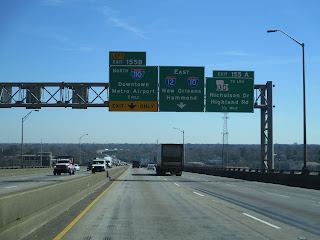
The following photos from my February 2023 visit to the Horace Wilkinson Bridge showcase the eastbound crossing of the bridge from West Baton Rouge to East Baton Rouge. Click on each photo to see a larger version.

The following photos from my February 2023 visit to the Horace Wilkinson Bridge showcase the westbound crossing of the bridge from East Baton Rouge to West Baton Rouge. Click on each photo to see a larger version.

The following photos from my January 2017 visit to the Horace Wilkinson Bridge showcase various vantage points from along the Mississippi Riverfront near downtown Baton Rouge. Click on each photo to see a larger version.

The following aerial photos from my February 2023 visit to the Horace Wilkinson Bridge showcase various views of the bridge and its surroundings along the Mississippi River. Click on each photo to see a larger version.

Dashcam video of the eastbound drive over the Horace Wilkinson Bridge was filmed in February 2023 for the 'roadwaywiz' YouTube channel and is available for viewing at the link below:

Dashcam video of the westbound drive over the Horace Wilkinson Bridge was filmed in February 2023 for the 'roadwaywiz' YouTube channel and is available for viewing at the link below:

The Horace Wilkinson Bridge was featured in the "Bridges of the Lower Mississippi River" webinar on the 'roadwaywiz' YouTube channel, beginning at the 1:50:20 mark:


How To Get There:

Further Reading:
Horace Wilkinson Bridge by John Weeks
Horace Wilkinson Bridge at historicbridges.org

Bridges, Crossings, and Structures of the Lower Mississippi River
Next Crossing upriver: Huey P. Long Bridge (Baton Rouge, LA)
Next Crossing downriver: Plaquemine Ferry (Plaquemine, LA)
Next Bridge downriver: Sunshine Bridge (Donaldsonville, LA)
Return to the Bridges of the Lower Mississippi River Home Page
__________________________________________________

Comments

Anonymous said…
They have opened the lanes going over the bridge to two lanes however it must squeeze to one merging lane when it gets to the I110 coming from the north. While the I-110 continues with 2 lanes. I-110 is a smaller less traffic interstate. This needs to change. Open up I10 to continue on with 2 lanes merging with only 1 lane entering from I-110. Then I 10 would continue to flow with the 2 lanes
Megz said…
I just need to know when those photos were taken bc this is by far THE BEST I’ve ever seen traffic ������
If you happen to be sitting at a standstill (a frequent occurrence) at the top of this bridge 175 feet above the river, you will feel the bridge noticeably shake with the heavy truck traffic. Scary.

Popular posts from this blog

Trimmer Springs Road (Fresno County)

Trimmer Springs Road is an approximately forty-mile rural highway located in Fresno County.  The corridor begins near in California State Route 180 in Centerville and extends to Blackrock Road at the Kings River in the Sierra Nevada range near the Pacific Gas & Electric Company town of Balch Camp. The roadway is named after the former Trimmer Springs Resort and was originally constructed to facilitate access to the Sanger Log Flume.  Trimmer Springs Road was heavily modified and elongated after construction of Pine Flat Dam broke ground in 1947.   Part 1; the history of Trimmer Springs Road Much of the original alignment of Trimmer Springs Road was constructed to facilitate access to the Sanger Log Flume.   The  Kings River Lumber Company  had been established in 1888 in the form of a 30,000-acre purchase of forest lands in Converse Basin.  This purchase lied immediately west of Grant Grove and came to be known as "Millwood."  The co...

When was Ventura Avenue east of downtown Fresno renamed to Kings Canyon Road? (California State Route 180)

California State Route 180 was one of the original Sign State Routes designated in August 1934.  The highway east of Fresno originally utilized what was Ventura Avenue and Dunlap Road to reach what was then General Grant National Park.  By late year 1939 the highway was extended through the Kings River Canyon to Cedar Grove.   In 1940 General Grant National Park would be expanded and rebranded as Kings Canyon National Park.  The Kings Canyon Road designation first appeared in publications circa 1941 when the California State Route 180 bypass of Dunlap was completed.  Kings Canyon Road ultimately would replace the designation of Dunlap Road from Dunlap to Centerville and Ventura Avenue west to 1st Street in Fresno.   The Kings Canyon Road would remain largely intact until March 2023 when the Fresno Council designated Cesar Chavez Boulevard.  Cesar Chavez Boulevard was designated over a ten-mile corridor over what was Kings Canyon Road, remaini...

Interstate 99 at 30

When it comes to the entirety of the Interstate Highway System, Interstate 99, when fully completed, is nothing more than 161 miles of a roughly 48,000-mile system (0.3% of total length).  Yet, to more than just a handful of people, the number '99' rubs them the wrong way. Interstate 99 follows the path of two US Highway Routes - US 220 from the Pennsylvania Turnpike in Bedford north to Interstate 80 and then to US 15/Interstate 180 in Williamsport.  It then follows US 15 from Williamsport north to Interstate 86 in Corning, New York. Interstate 99 runs with US 220 through much of Central Pennsylvania. (Doug Kerr) US 220 from Cumberland, Maryland to Interstate 80 and US 15 north of Williamsport were designated part of the Appalachian Highway System in 1965.  Construction to upgrade both corridors progressed steadily but slowly.  In 1991, the two corridors were included as a National High Priority Corridor.  The route from Cumberland to Corning consisted of High P...