
Horace Wilkinson Bridge (Baton Rouge, LA)

Standing tall across from downtown Baton Rouge, the Horace Wilkinson Bridge carries Interstate 10 across the lower Mississippi River between West Baton Rouge and East Baton Rouge Parishes. Unusually, the bridge is actually named for three separate people; three generations of Horace Wilkinsons who served in the Louisiana State Legislature over a combined period of 54 years.

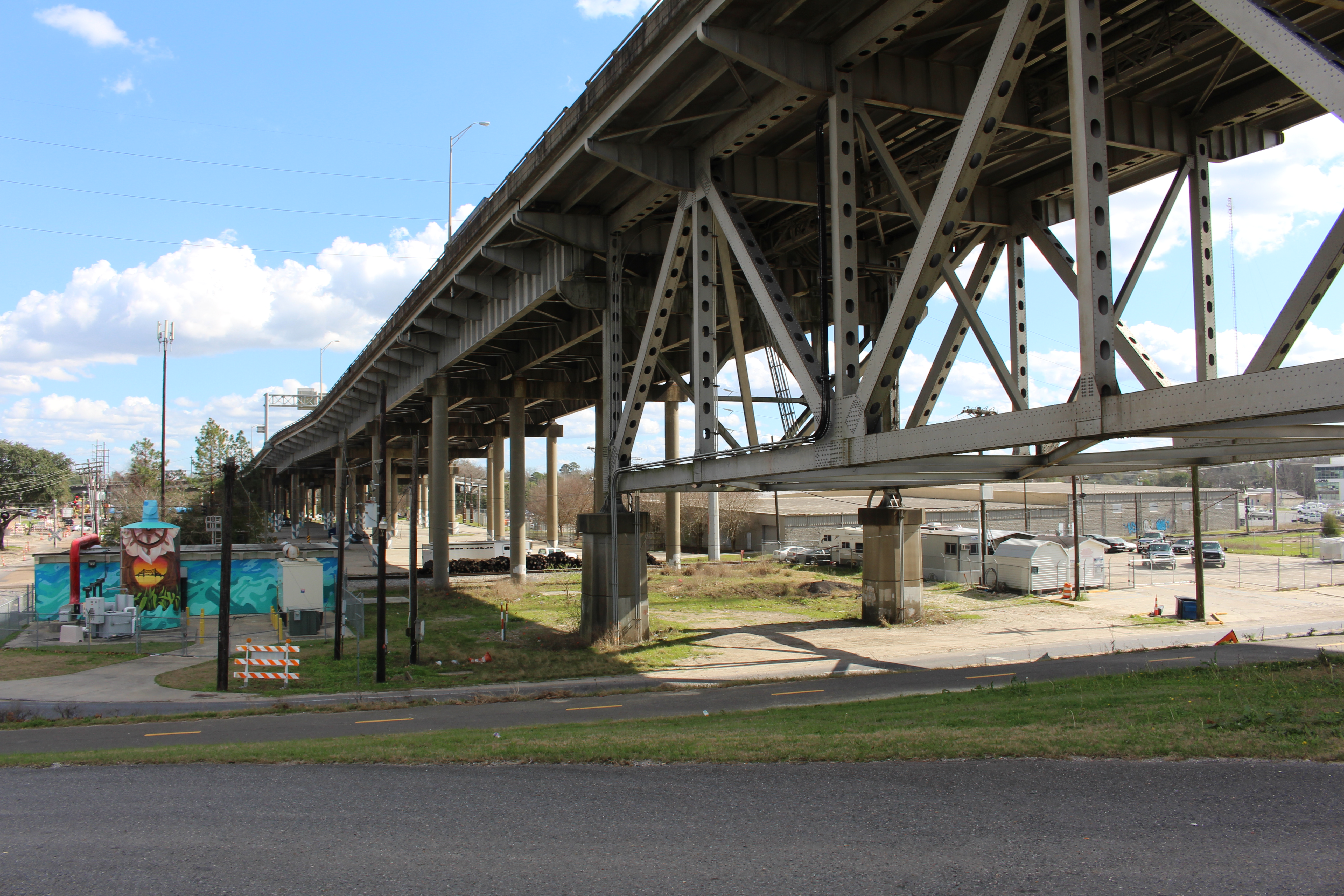
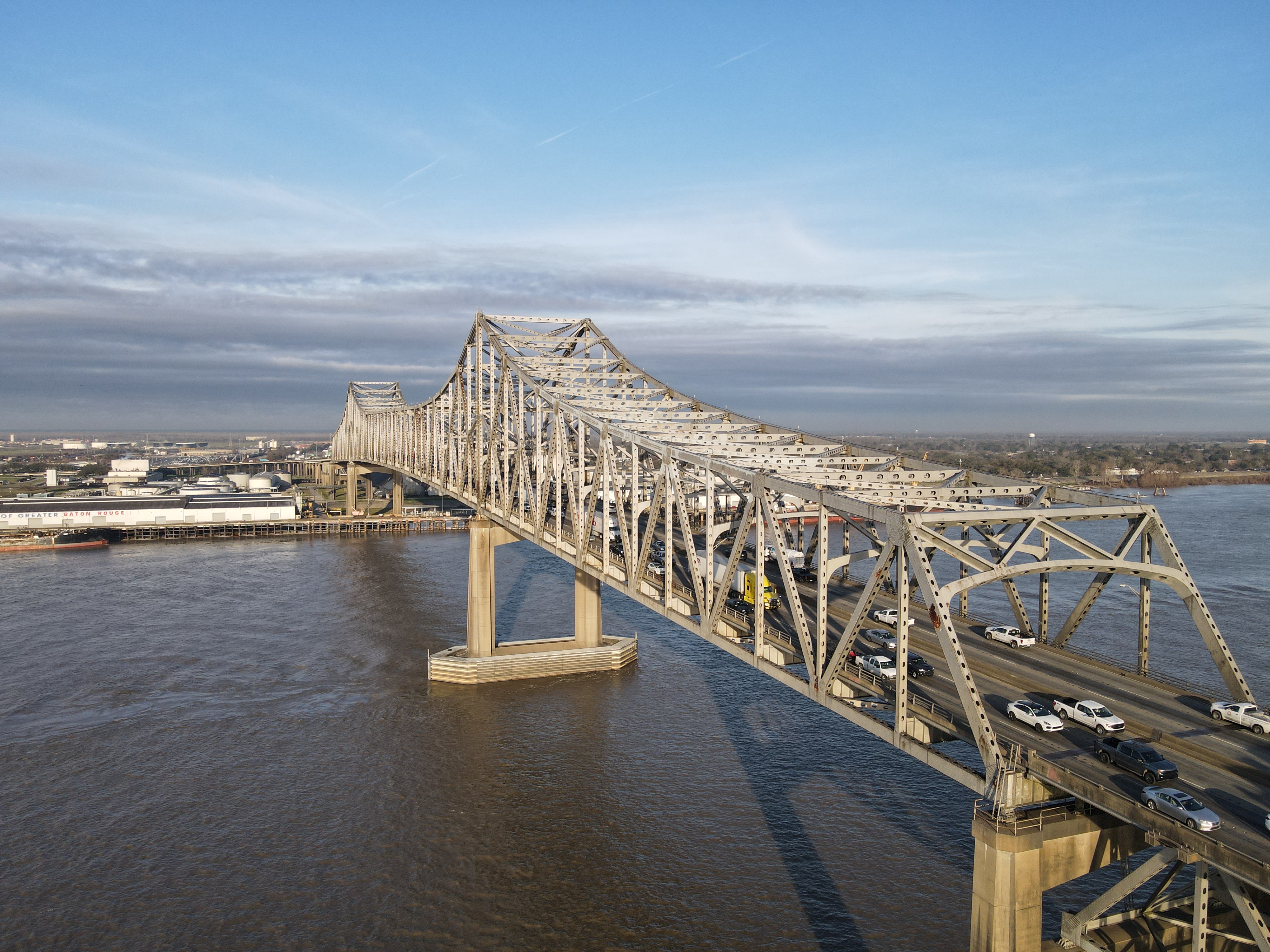
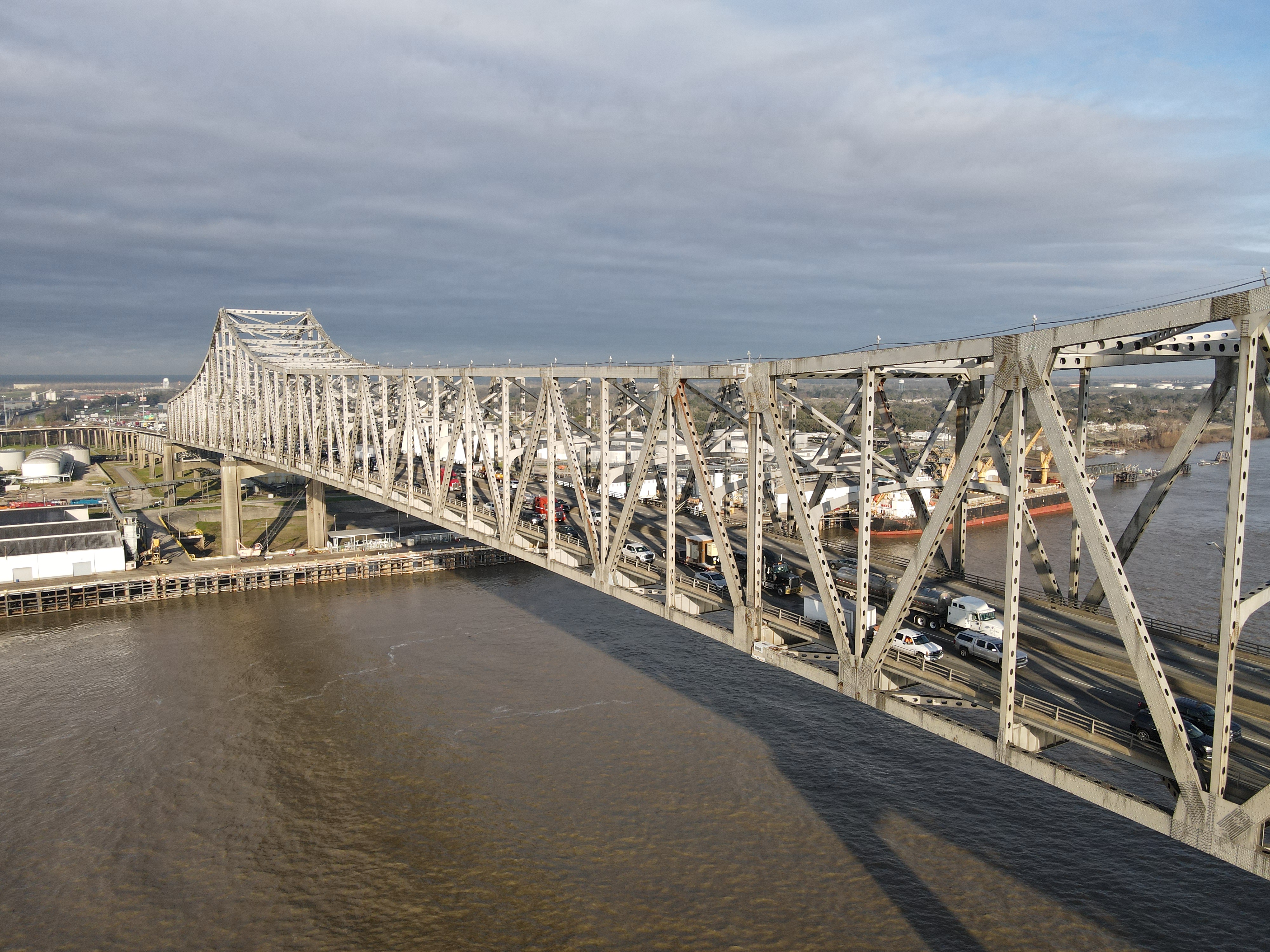
Constructed in the 1960s and opened to traffic in 1968, this is one of the largest steel bridges on the lower Mississippi. It’s also the tallest bridge across the Mississippi, with its roadway reaching 175 ft at the center span. Baton Rouge is the northernmost city on the river where deep-water, ocean-going vessels can operate. As a result, this bridge is the northernmost bridge on the river of truly gigantic proportions. Altogether, the bridge is nearly 2 ½ miles long and its massive truss superstructure is 4,550 ft long with a center main truss span of 1,235 ft.

The Horace Wilkinson Bridge is one of the largest and busiest bridges on the lower Mississippi River. As time has gone on, it's become clear that this bridge is not capable of handling the ever-increasing cross-river traffic demands of the region.

As part of the busy I-10 corridor across southern Louisiana, this bridge sees some of the heaviest traffic of any bridge on the lower Mississippi. This problem is compounded by the fact that for a metropolitan area the size of Baton Rouge (the state’s capital and 2nd largest metro area), cross-river traffic is handled by only two bridges, the other being the much older Huey P. Long Bridge a short distance to the north. The high amount of local traffic mixing with the already significant long-distance traffic on the interstate makes for a bridge that is always prone to congestion at all hours of the day. In addition, the bridge’s roadway lacks full shoulders, a common safety feature on most interstate highway bridges. The roadway does carry six lanes for traffic, yet two of these lanes (one per direction) are reserved for local entering/exiting traffic at the interchanges on each bridge approach. 

Altogether, this is a bridge that has needed supplementation for many years and the state of Louisiana is not in a position at this time to offer any significant solutions to the traffic bottleneck that the bridge and its approaches represent. The state has instead chosen to pursue bridge projects in other areas of the lower Mississippi basin that have had negligible impacts on traffic congestion, whether in the Baton Rouge area or elsewhere, and the state has generally neglected the needs of its capital region by overlooking the traffic demands generated in this particular stretch of the river. In this author’s opinion, southern Louisiana would be well-served to consider the construction of a third bridge in Baton Rouge, whether as a parallel span for the existing Wilkinson Bridge, or on an alignment nearby that would enable much of the long distance traffic on the interstate to bypass Baton Rouge. The two bridges that serve this area are not getting any younger and it may be time to take their age and lessening effectiveness seriously so that a real effort may emerge to modernize the region’s transportation infrastructure with the goal that it will be compatible with the demands of the 21st Century. 

The following photos from my February 2023 visit to the Horace Wilkinson Bridge showcase the eastbound crossing of the bridge from West Baton Rouge to East Baton Rouge. Click on each photo to see a larger version.

The following photos from my February 2023 visit to the Horace Wilkinson Bridge showcase the westbound crossing of the bridge from East Baton Rouge to West Baton Rouge. Click on each photo to see a larger version.

The following photos from my January 2017 visit to the Horace Wilkinson Bridge showcase various vantage points from along the Mississippi Riverfront near downtown Baton Rouge. Click on each photo to see a larger version.

The following aerial photos from my February 2023 visit to the Horace Wilkinson Bridge showcase various views of the bridge and its surroundings along the Mississippi River. Click on each photo to see a larger version.

Dashcam video of the eastbound drive over the Horace Wilkinson Bridge was filmed in February 2023 for the 'roadwaywiz' YouTube channel and is available for viewing at the link below:

Dashcam video of the westbound drive over the Horace Wilkinson Bridge was filmed in February 2023 for the 'roadwaywiz' YouTube channel and is available for viewing at the link below:

The Horace Wilkinson Bridge was featured in the "Bridges of the Lower Mississippi River" webinar on the 'roadwaywiz' YouTube channel, beginning at the 1:50:20 mark:


How To Get There:

Further Reading:
Horace Wilkinson Bridge by John Weeks
Horace Wilkinson Bridge at historicbridges.org

Bridges, Crossings, and Structures of the Lower Mississippi River
Next Crossing upriver: Huey P. Long Bridge (Baton Rouge, LA)
Next Crossing downriver: Plaquemine Ferry (Plaquemine, LA)
Next Bridge downriver: Sunshine Bridge (Donaldsonville, LA)
Return to the Bridges of the Lower Mississippi River Home Page
__________________________________________________

Comments

Anonymous said…
They have opened the lanes going over the bridge to two lanes however it must squeeze to one merging lane when it gets to the I110 coming from the north. While the I-110 continues with 2 lanes. I-110 is a smaller less traffic interstate. This needs to change. Open up I10 to continue on with 2 lanes merging with only 1 lane entering from I-110. Then I 10 would continue to flow with the 2 lanes
Megz said…
I just need to know when those photos were taken bc this is by far THE BEST I’ve ever seen traffic ������
If you happen to be sitting at a standstill (a frequent occurrence) at the top of this bridge 175 feet above the river, you will feel the bridge noticeably shake with the heavy truck traffic. Scary.

Popular posts from this blog

Old US Route 60/70 through Hell (Chuckwall Valley Road and Ragsdale Road)

Back in 2016 I explored some of the derelict roadways of the Sonoran Desert of Riverside County which were part of US Route 60/70; Chuckwalla Valley Road and Ragsdale Road. US 60 and US 70 were not part of the original run of US Routes in California.  According to USends.com US 60 was extended into California by 1932.  US 60 doesn't appear on the California State Highway Map until the 1934 edition. USends.com on US 60 endpoints 1934 State Highway Map Conversely US 70 was extended into California by 1934, it first appears on the 1936 State Highway Map. USends.com on US 70 endpoints 1936 State Highway Map When US 60 and US 70 were extended into California they both utilized what was Legislative Route Number 64 from the Arizona State Line west to Coachella Valley.  LRN 64 was part of the 1919 Third State Highway Bond Act routes.  The original definition of LRN 64 routed between Mecca in Blythe and wasn't extended to the Arizona State Line until 1931 acc...

The last 1956-63 era California Sign State Route Spade?

Along southbound California State Route 170 (the Hollywood Freeway Extension) approaching the Hollywood Freeway/Ventura Freeway interchange a white California State Route 134 Sign State Route Spade can be observed on guide sign.  These white spades were specifically used during the 1956-63 era and have become increasingly rare.  This blog is intended to serve as a brief history of the Sign State Route Spade.  We also ask you as the reader, is this last 1956-63 era Sign State Route Spade or do you know of others?  Part 1; the history of the California Sign State Route Spade Prior to the Sign State Route System, the US Route System and the Auto Trails were the only highways in California signed with reassurance markers.  The creation of the US Route System by the American Association of State Highway Officials during November 1926 brought a system of standardized reassurance shields to major highways in California.  Early efforts to create a Sign State Route ...

Paper Highways; Interstate H-4 through downtown Honolulu

The Hawaiian Island of O'ahu is home to four Interstate Highways; H-1, H-2, H-3 and H-201.  Had history gone slightly differently during the 1960s a fifth Interstate corridor on O'ahu could have been constructed through downtown Honolulu and the neighborhood of Waikiki.  The proposed corridor of Interstate H-4 can be seen above as it was presented by the Hawaii Department of Transportation during October 1968 .   This page is part of the Gribblenation O'ahu Highways page.  All Gribblenation and Roadwaywiz media related to the highway system of O'ahu can be found at the link below: https://www.gribblenation.org/p/gribblenation-oahu-highways-page.html The history of proposed Interstate H-4 The corridor of Interstate H-4 was conceived as largely following what is now Hawaii Route 92 on Nimitz Highway and Ala Moana Boulevard.   Prior to the Statehood the first signed highways within Hawaii Territory came into existence during World War II.    Dur...