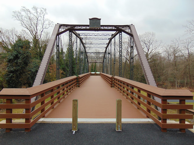
While the number of historic iron truss and metal truss bridges has been dwindling over the years due to several factors, occasionally a bridge will be preserved for its historical value. Such is the case of the Inwood Iron Bridge, which was built in 1899 and located near Lickdale, Pennsylvania. The Inwood Iron Bridge was fabricated by the Pittsburgh Bridge Company and erected by Nelson and Buchanan of Chambersburg, Pennsylvania. It is historically significant as one of the oldest surviving Pennsylvania thru truss highway bridges in Pennsylvania. Early examples of Pennsylvania (Petit) thru-truss highway bridges from before the 20th Century were not common as the design was more often used for railroad bridges. Only a handful of such roadway bridges have been identified around Pennsylvania, making the Inwood Iron Bridge more historically significant.
The 151-foot-long Inwood Iron Bridge crossed Swatara Creek and was located not far from Swatara State Park in Lebanon County, Pennsylvania. Closed to traffic in 2006. After over 100 years of use, time and wear had taken their toll on the bridge, and the bridge had deteriorated to a point where it was no longer structurally sound to carry traffic. As the closing of the Inwood Iron Bridge had left only one method of egress for residents living along the east bank of the Swatara Creek, there had been considerations of rehabilitating the bridge. However, local officials noted the need for emergency vehicles, buses, and other heavy vehicles at this crossing and looked for ways the bridge could be rehabilitated to accommodate heavier vehicles. For the bridge to be able to accommodate heavier load capacities, it was found that many of the truss members needed to be replaced.
It was determined that the historic bridge could not be rehabilitated to meet the unique needs of modern-day traffic without significantly altering the bridge's character. Also, the cost of rehabilitation of the bridge to accommodate heavier loads exceeded the cost of a new structure. Fortunately, the Pennsylvania State Department of Transportation has a program in place that focuses on the reuse of historic metal truss bridges as pedestrian or light vehicular bridges on trails or in parks. Given the Inwood Iron Bridge's historic significance as one of the new remaining Pennsylvania thru-truss highway bridges, a strong case was made for its preservation. The land for a park was found about a quarter mile downstream from the bridge's original location on Iron Bridge Road thanks to a land sale of only $2.00 by a couple of residents. Thus, a small park was created for the bridge and efforts to move the bridge to the new location started in 2019.
In July 2019, the Inwood Iron Bridge was lifted off its original abutments and then disassembled. The individual bridge members were repaired or replaced at another location. After rehabilitation was completed and a fresh coat of paint was given to the bridge, the bridge was then reassembled at its new location at the Inwood Iron Bridge Park. A substructure, parking spaces, a short walking trail, and informational plaques were installed so the bridge park could be opened in 2020.
I visited the Inwood Iron Bridge Park in January 2004 during a trip through this area of Pennsylvania. You can easily walk along the bridge, or even under the bridge. Efforts were made for the bridge to be accessible for all ability levels. I feel that much consideration and care was given to restoring the bridge and honoring its historical significance. You can combine a visit to the Inwood Iron Bridge with another bridge nearby that was relocated due to its historical significance, the Waterville Bridge. This was a great pit stop for the explorer and bridge hunter in me.
 |
| Taking a walk down the restored Inwood Iron Bridge. |
 |
| Checking out some of the unique features of this Pennsylvania thru-truss bridge. |
 |
| Side profile of the Inwood Iron Bridge. |
 |
| Taking a look underneath the Inwood Iron Bridge. |
 |
| Bridge plaque on top of the bridge stating who had built the bridge. |
 |
| The Inwood Iron Bridge at its former location upstream on the Swatara Creek. This bridge could be viewed from PA 72 when I took this picture in April 2009. |
How to Get There:
Sources and Links:
Pennsylvania State Preservation - Bridge Preservation and Education: A Site Visit to the Inwood Iron Bridge
McCormick Taylor - Inwood Iron Truss Bridge Rehabilitation and Relocation
LebTown - Historic Inwood Bridge off the Swatara, being readied for new placement
Pennsylvania State Preservation - Ironing Out the Wrinkles: Finding a New Life for the Inwood Iron Bridge
Lebanon Daily News - Historic bridge over the Swatara to get a new home
Crossposted to our Quintessential Pennsylvania site at: https://quintessentialpa.blogspot.com/2024/01/inwood-iron-bridge-lebanon-county.html


Comments