Located about halfway between Baton Rouge and New Orleans in
southern Louisiana, the Sunshine Bridge spans the lower Mississippi River near
the city of Donaldsonville as part of the longer Louisiana Highway 70 corridor,
which connects Interstate 10 and Airline Highway (US 61) with US 90 in Morgan
City.
In the years following World War II, the only bridges across the lower Mississippi River in Louisiana were located in the area of the state’s two largest cities – Baton Rouge and New Orleans. Postwar agricultural and industrial development along the river in this region led to the planning of a series of infrastructure projects in southern Louisiana that were aimed at spurring this development and modernization of the Delta region. One of these projects was known as the Acadian Thruway and was developed in the 1950s as a toll road intended to connect greater New Orleans with Lafayette and points west while providing a high-speed bypass of the Baton Rouge metro area. The Thruway, which would have been engineered and designed in the style of many of the turnpikes that were contemporaneously built in the northeastern states in the postwar years, was proposed to include the construction of a new Mississippi River bridge near the city of Donaldsonville and would have been the state of Louisiana’s first modern “superhighway”. The creation of the interstate highway system with the passage of the Federal Aid Highway Act of 1956 put an end to this proposal, as the 90% federal funding of the proposed Interstate 10 corridor proved to be far more advantageous for Louisiana. Even with the cancellation of the Acadian Thruway project, the idea of building a new bridge on the Mississippi River at Donaldsonville persisted, with the proposed site of the Thruway bridge serving as the eventually selected location when ground broke on the bridge project in 1962.

This excerpt from the 1956 Rand McNally map of the state of Louisiana shows the proposed alignment of the Acadian Thruway toll road, stretching westward from the Airline Highway (US 61) corridor, across the Mississippi River at Donaldsonville, and continuing west in the direction of Lafayette. The project was eliminated from consideration with the advent of the Interstate Highway System, but the Sunshine Bridge was built at the location of the proposed turnpike.
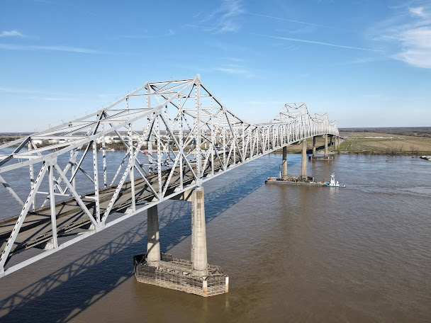
Completed in 1964, the Sunshine Bridge is a truly massive structure, one of the largest steel bridges on the lower Mississippi River. It’s superstructure is similar in concept to that which is found on the nearby Huey P. Long Bridge in Baton Rouge, as well as the Natchez-Vidalia Bridge further upriver. The difference in this case, is that the end product is even larger, a fact necessitated by the bridge’s location on the southernmost stretch of the Mississippi – the stretch that is frequented by deep-water, ocean-going vessels. Due to its presence in the low-lying areas of the coastal delta, the bridge towers above the surrounding landscape and can be easily viewed from miles away in most directions. The bridge totals about 1 ½ miles long from end to end and features a central steel truss superstructure that is about 3,300 ft long with its longest individual main spans being about 825 ft apiece. Its unusual four-tower, five-span structure gives the bridge an unmistakable and immediately recognizable appearance. The bridge’s massive proportions and unique structural design combine to make it one of my personal favorite bridges on the entire Mississippi River and it is one I’ve had the privilege to visit multiple times since 2017.

The Sunshine Bridge sports one of the longest steel superstructures of any bridge on the lower Mississippi River. Its 3,300 ft steel truss superstructure is spread out across five spans, the longest of which is 825 ft.
Upon its completion, the Sunshine Bridge was
operated as a toll bridge. The toll was discontinued in 2001 following an act
passed in the Louisiana State Legislature. It took several years after its
completion for the surrounding road network on the west bank of the river to
fully integrate with the bridge. This led critics of the project to label it a “Bridge
to Nowhere”, however upon the completion of the LA Highway 70 corridor in
subsequent years and the connections to Donaldsonville, this area of Ascension
Parish became an economically viable corner of the state and the bridge’s
purpose was solidified.
The bridge’s name is a nod to singer-songwriter and Louisiana politician Jimmie Davis, who served two terms as the 47th Governor of Louisiana and was in office at the time of the bridge’s construction. Davis, who was inducted into the Country Music Hall of Fame in 1972, rose to national fame in 1940 with his hit song “You Are My Sunshine” and after declining an offer to name the bridge in his honor, it was named “Sunshine Bridge” as a reference to his popular song. In this atypical case, we have a bridge here that's named for the title of a song, instead of being named for a person or geographic feature.

American singer & songwriter Jimmie Davis (1899-2000) served two non-consecutive terms as Louisiana's 47th Governor (1944-1948, 1960-1964)
Further Reading:
Sunshine Bridge by John Weeks
Sunshine Bridge at historicbridges.org
Bridges, Crossings, and Structures of the Lower Mississippi River
Next Crossing upriver: Plaquemine Ferry (Plaquemine, LA)
Next Bridge upriver: Horace Wilkinson Bridge (Baton Rouge, LA)
Next Crossing downriver: Veterans Memorial Bridge (Gramercy, LA)
Return to the Bridges of the Lower Mississippi River Home Page
__________________________________________________


Comments