Lloydminster Border Markers - Alberta / Saskatchewan


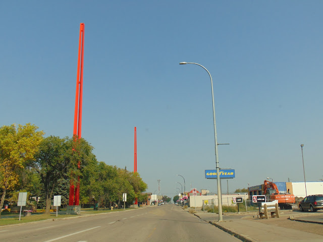
The border markers that stand tall accentuate the story of Canada's border city. It's a story of a town, but two provinces. Lloydminster straddles the border between Alberta and Saskatchewan, and there are four giant red border markers at about 100 feet tall each in the center of town around the vicinity of City Hall and the Yellowhead Highway (Highway 16 in both provinces). Near the crossing of Highway 16 and Highway 17 (which follows the border between the two provinces) next to Lloydminster City Hall, the four markers stand on the boundary, representing the four themes of the story of Lloydminster, which includes the oil and gas industry, the Barr Colonists that founded Lloydminster, agriculture, and First Nations and MĆ©tis peoples. The gap between the steel pillars of each monument represents the actual border, and the border markers were erected in 1994.

Lloydminster was first settled by the Barr Colonists in 1903, which predated the creation of the border between Alberta and Saskatchewan, which became a province in 1905. The provincial border runs through the middle of the city through the Dominion Land Survey's Fourth Meridian, also known as the 110th meridian west. In 1930, Lloydminster was chartered in both provinces, thus making it the only municipality in North America to be chartered in two jurisdictions. However, modern GPS has shown that the border and meridian are slightly off. In 2005, it was discovered that the Fourth Meridian, which was surveyed during the 1870s, had turned out to be inaccurate. As a result, the true meridian doesn't run north-south along Lloydminster's 50th Avenue, but rather a few blocks to the east. However, the border markers are not going anywhere, standing as a testament to Lloydminster's unique status in the world.


Traveling east on the Yellowhead Highway (AB 16/SK 16), where a sign marking the border has been placed near one of the tall border markers.

Traveling west on the Yellowhead Highway, you can see two of the border markers (one is obscured by the trees). AB/SK 17 follows the provincial border as well.


How to Get There:


Sources and Links:
Tourisme Alberta - Border Markers
Tony Bloom Studios - Border Markers
City of Lloydminster - Border Markers
Behind the Hedge - North Along the Fourth Meridian
Conde Nast Traveler - The Strange Story Behind One Canadian City's Border Confusion (Ken Jennings - February 23, 2015)

Comments

Popular posts from this blog

Hawaii Route 8930

Hawaii Route 8930 is a 2.5-mile State Highway on the Island of O'hau.  Hawaii Route 8930 is aligned over Kualakai Parkway over the course of its entire alignment south from Interstate H-1 to Kapolei Parkway.  Hawaii Route 8930 is one of the newest Hawaii Routes only having been completed during 2010.   This page is part of the Gribblenation O'ahu Highways page.  All Gribblenation and Roadwaywiz media related to the highway system of O'ahu can be found at the link below: https://www.gribblenation.org/p/gribblenation-oahu-highways-page.html Part 1; the history of Hawaii Route 8930 The history of Hawaii Route 8930 is brief given it is a modern facility.  Hawaii Route 8930 and what was known as "North-South Road" were built to facilitate the developing areas of Kapolei on western O'ahu.  According to hawaiihighways.com the first stage of Hawaii Route 8930 was completed from Kapolei Parkway north to Farrington Highway as a four-lane highway during November...

Madera County Road 607 and the Stockton-Los Angeles Road

Madera County Road 607 is an approximately seven-mile rural unsurfaced highway which spans from Road 600 near Raymond west to Road 29.   Road 607 west from Raymond Road Cemetery (established in 1905) is part of the Stockton-Los Angeles Road corridor surveyed in 1853. The corridor lies in the gap between Fresno Crossing at the Fresno River west to Newton's Crossing at the Chowchilla River. The Buchanan Copper Mine would be along what is now Road 607 in the namesake Buchanan Hollow during July 1863. The Buchanan Mine is thought to have once had a population of between 1,000-1,500 residents by the early 1870s. Copper prices would decline in the decade after the Civil War and much of the activity at Buchanan shifted towards cattle ranching. The last businesses in the community would shutter during World War II and it is now a true ghost town. Part 1; the history of Madera County Road 607 and the Stockton-Los Angeles Road What is now Road 607 was a component of the larger Sto...

Paper Highways; Interstate H-4 through downtown Honolulu

The Hawaiian Island of O'ahu is home to four Interstate Highways; H-1, H-2, H-3 and H-201.  Had history gone slightly differently during the 1960s a fifth Interstate corridor on O'ahu could have been constructed through downtown Honolulu and the neighborhood of Waikiki.  The proposed corridor of Interstate H-4 can be seen above as it was presented by the Hawaii Department of Transportation during October 1968 .   This page is part of the Gribblenation O'ahu Highways page.  All Gribblenation and Roadwaywiz media related to the highway system of O'ahu can be found at the link below: https://www.gribblenation.org/p/gribblenation-oahu-highways-page.html The history of proposed Interstate H-4 The corridor of Interstate H-4 was conceived as largely following what is now Hawaii Route 92 on Nimitz Highway and Ala Moana Boulevard.   Prior to the Statehood the first signed highways within Hawaii Territory came into existence during World War II.    Dur...