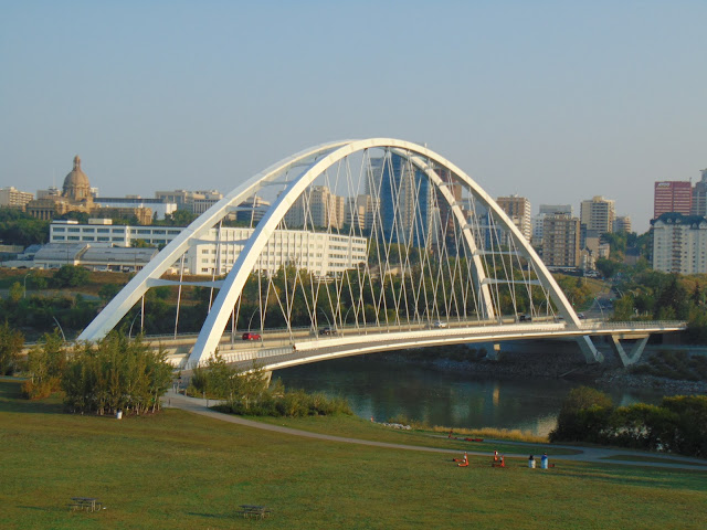
Walterdale Bridge - Edmonton, Alberta


Located in Edmonton, Alberta, the Walterdale Bridge was opened in 2017 and carries northbound traffic across the North Saskatchewan River from Queen Elizabeth Park into the Rossdale neighborhood and downtown Edmonton. Named for an early area settler and local ferry operator by the name of John Walter, the bridge replaced the first Walterdale Bridge, which was a steel truss built in 1913. Southbound traffic going across the river takes the nearby High Level Bridge. The bridge has also become a feature in Edmonton's skyline.

Construction on the $155 million project began in 2013. The new 755-foot-long (230.1-meter-long) Walterdale Bridge features a signature arch structure, at more than 160 feet tall (48.75 meters), which serves as a gateway to Edmonton's downtown for motorists, cyclists, and pedestrians. The bridge features a double metal arch bridge with an inward-slanting arch towards its apex. As the Walterdale Bridge is located on parkland, it was a simple decision to build the current bridge right next to the old bridge. It was decided to increase the capacity of the new Walterdale Bridge compared to the old one, increasing it from two lanes to three lanes in a single direction, and a pedestrian walkway, with the option to widen the deck and create a fourth lane in the future, presenting plenty of options to improve traffic flow as the needs of Edmonton's transportation network evolves.

A view of the Walterdale Bridge in the early morning light.

The Walterdale Bridge has prominence among Edmonton's skyline from this knoll at Queen Elizabeth Park.

Another view of the Walterdale Bridge from Queen Elizabeth Park. The Alberta Legislative Building is towards the left of the photo.

A northbound view of the Walterdale Bridge.


How to Get There:


Sources and Links:
City of Edmonton - Walterdale Bridge
Kebony - Walterdale Bridge
Acconia - Walterdale Bridge
HistoricBridges.org - Walterdale Bridge
Acconia - The Walterdale bridge: a major engineering feat that enhances a city
Global News - Edmonton mulls Walterdale Bridge 2-way traffic flow changes amid upcoming construction

Comments

Popular posts from this blog

Interstate 40's Tumultuous Ride Through the Pigeon River Gorge

In the nearly 60 years Interstate 40 has been open to traffic through the Pigeon River Gorge in the mountains of Western North Carolina, it has been troubled by frequent rockslides and damaging flooding, which has seen the over 30-mile stretch through North Carolina and Tennessee closed for months at a time. Most recently, excessive rainfall from Hurricane Helene in September 2024 saw sections of Interstate 40 wash away into a raging Pigeon River. While the physical troubles of Interstate 40 are well known, how I-40 came to be through the area is a tale of its own. Interstate 40 West through Haywood County near mile marker 10. I-40's route through the Pigeon River Gorge dates to local political squabbles in the 1940s and a state highway law written in 1921. A small note appeared in the July 28, 1945, Asheville Times. It read that the North Carolina State Highway Commission had authorized a feasibility study of a "...water-level road down [the] Pigeon River to the Tennessee l...

Bleriot Ferry - Alberta

  Alberta operates six ferries scattered throughout the province. Roughly twenty to twenty-five kilometers up the Red Deer River from the town of Drumheller is one of the most scenic ferry crossings in all of Wild Rose Country, the Bleriot Ferry. Using the North Dinosaur Trail (Alberta Highway 838, or AB 838), the Bleriot Ferry provides a scenic river cruise of sorts in the Canadian Badlands. The Bleriot Ferry started operating in 1913 as the Munson Ferry when a few bridges crossed the Red Deer River. The ferry was started by Andre Bleriot, the brother of famed early aviator Louis Bleriot, who became famous for being the first person to fly over the English Channel. At the time, the Alberta provincial government commissioned local residents to run the ferries. There were several ferries along the Red Deer River, and not only did they serve as vital transportation links, but they also served as local social hubs, since everyone had to take the ferries to go places. Over time, as the...

Massena Center Suspension Bridge

The Massena Center Bridge, also known as the Holton D. Robinson Bridge, has had quite the tumultuous history. Situated on the Grasse River just east of Massena, New York in the hamlet of Massena Center, the Massena Center Bridge is a reminder of the efforts the community has made in order to connect over the river. The first and only other known bridge to be built at Massena Center was built in 1832, but that bridge was never long for this world. During the spring of 1833, the Grasse River dammed itself due to an ice dam, flooded and lifted the bridge off its foundation, destroying the bridge in the process.  The floods were frequent in the river during the spring, often backing up the river from Hogansburg and past Massena Center, but not to nearby Massena. After the first bridge disappeared, local residents had to resort to traveling seven miles west to Massena to cross the next closest bridge, and that was no easy task for a horse and buggy. However, it was many decades befo...