Ranked as one of the world's most scenic drives by National Geographic, Condè Nast, and numerous other publications, the Icefields Parkway in Banff National Park and Jasper National Park in the Canadian province of Alberta is on many travel bucket lists. A 232-kilometer (144 miles) long ribbon of pavement that goes through the majestic scenery of the Canadian Rockies, the Icefields Parkway passes along towering mountains, pristine lakes, and even glaciers. It was the allure of this magnificent scenery that led me to experience the Icefields Parkway for myself in the middle of September 2024, following the path between Lake Louise and Jasper that many others before me had also experienced. The Icefields Parkway is part of Alberta Highway 93 (AB 93), which connects Jasper National Park and Banff National Park with Kootenay National Park in British Columbia, and beyond.
The story of the Icefields Parkway goes back tens of millions of years when tectonic forces pushed up the ocean floor and transformed it into the mountains that make the Canadian Rockies. Since then, ice, water, and wind shaped the mountains and valleys that we know today. For centuries, indigenous peoples hunted and traded over the mountain passes and valleys, and the earliest European travelers sought out indigenous guides and followed them along trade and hunting routes. In 1827, David Douglas, a botanist in service of the Hudson Bay Company, was struck by the impressive size of two mountains on either side of the Athabasca Pass in the Canadian Rockies, comparing the mountains to the Himalayas. He recorded their elevations as the highest points in Western Canada, starting decades of expeditions by mountaineers trying to find and conquer them. While it was later proven that there are much higher mountains in Canada, namely along the Saint Elias Mountains that line the borders between British Columbia, Yukon, and Alaska, the mountain scenery along the Icefields Parkway remains unforgettable in every way.
But perhaps it was in 1884 when the roots of the modern Icefields Parkway began to take shape. That year, Professor Arthur Coleman, a geologist with the University of Toronto, visited the Canadian Rockies in search of the legendary mountains made famous by David Douglas. Using journals and maps, Coleman negotiated the Great Divide from Banff to Jasper House, in search of the elusive mountain. Although unsuccessful in his quest, as Coleman followed the Sunwapta River to Jasper, he ultimately discovered what would later become the route of Alberta Highway 93, better known as the Icefields Parkway. I would say that's a worthwhile trade-off.
With Arthur Coleman's discovery and the arrival of railroads crisscrossing the Canadian Rockies, surveyors and tourists began to experience the beautiful scenery of this land. By the late 19th Century, mountain guides led tourists and mountaineers through the rugged terrain of Alberta's Rocky Mountains, making the area an early hub for alpine tourism. This led to the creation of Banff National Park in 1885 and Jasper National Park in 1907, along with a road that was used by tourists on horseback and was first known as the Wonder Trail.
It was Arthur Oliver Wheeler, the principal land surveyor plotting the border between Alberta and British Columbia, who predicted that a road would be needed to connect Banff National Park and Jasper National Park. In a journal entry from 1920, Wheeler wrote "Through dense primeval forests, muskeg, burnt and fallen timber and along rough and steeply sloping hillsides, a constant flow of travel will demand a broad, well-ballasted motor road. This wonder trail will be world-renowned."
In 1931 as part of a Depression Era economic project, Canada's government recruited six hundred unemployed men to build a road along this Wonder Trail. The new highway was set to be a 232-kilometer-long single-lane gravel track connecting Lake Louise and Jasper. The pay was meager, but it kept people employed. Workers were paid $5 a month and received a stipend for tobacco and clothing. Foremen received $60 a month. To employ as many men as possible, the road was carved mainly by hand with the aid of horses that pulled graders, plows, and wagon loads of earth and one small mechanized tractor per camp. Surveyors made the route up as they went and if too much work was required to fill depressions or remove hills, the line was relocated. After years of hard work, by 1940, Alberta had created the first road in the world that could bring motorists to the toe of a glacier and the Icefields Parkway was ready to welcome visitors.
Since the highway's opening in 1940, the Icefields Parkway has witnessed different groups frequenting the area. During World War II, allied soldiers used the area around the Icefields Parkway as part of combat training. The United States Army's 87th Mountain Infantry spent two months on the Columbia Icefield during World War II, testing an over-snow vehicle while British and American armies practiced mountain warfare on the glaciers. After World War II ended, cars rose in popularity and as more drivers discovered the Icefields Parkway, tourism began to take off. The first snow machine tours onto the Athabasca Glacier were offered and travelers flocked to the mountains to the Canadian Rockies. By 1961, the Icefields Parkway was widened, realigned as necessary, and paved due to its increased traffic and popularity. Various attractions, viewpoints, and campgrounds along the Icefields Parkway made adventure accessible to everyone. Today, over 1.2 million people travel the Icefields Parkway each year, mostly during the summer months, mainly by private vehicle or by charter bus that can make the journey in just a few hours.
My own experience traveling on the Icefields Parkway was in September 2024 and one of the capstone experiences I had during my vacation around Alberta and British Columbia, fulfilling a bucket list item that I was finally able to check off. Even with the devastating wildfires at Jasper National Park that took place in July 2024, I was able to see many of the highlights along the Icefields Parkway, and a few points of interest closer to Jasper had been cleared of wildfire destruction and reopened just a few days before my drive. With the aftermath of the wildfire in mind, I chose to drive the Icefields Parkway at the end of my trip, as I was staying in Calgary and needed to reach Edmonton by that night to catch my flight home to Upstate New York. While I could have spent days exploring every nook and cranny along the Icefields Parkway, I spent about six hours total traveling north on the road from Lake Louise to Jasper, between driving and leaving time to explore.
 |
| The excitement of the Icefields Parkway started for me as I exited off Trans-Canada Highway 1, which is also a very scenic ride as it makes its way through Banff National Park and Yoho National Park in the Canadian Rockies. I couldn't have picked a better day for weather to put my phone on do not disturb status, as cell phone reception is very rare along the Icefields Parkway, or Promenade des Glaciers in the French language. |
 |
| The scenery is already amazing along the beginning stretches of the Icefields Parkway. It started off as a chilly morning, but it was a bluebird day all along. |
 |
| I lucked out as far as the weather was concerned. Conditions along the Icefields Parkway can often be threatened with rain and low clouds, or even snow, depending on the season. With the weather on my side, I enjoyed the beautiful scenery that the Icefields Parkway is known for. |
 |
| This also led to some enchanting reflections along the many lakes and rivers that dot the surroundings of the Icefields Parkway. This is at Bow Lake. |
 |
| Back on the road, here's a view of Mount Jimmy Simpson. |
 |
| At 2,067 meters (or 6,781 feet), Bow Pass is the highest elevation of the Icefields Parkway, just 37 meters higher above sea level than Sunwapta Pass to the north. |
Some 40 kilometers north of Lake Louise, near the crest of Bow Pass, I stopped to see Peyto Lake, which has a short, but popular hiking trail that leads to a scenic viewpoint of Peyto Lake and Peyto Glacier. The lake and glacier were named for an early outfitter by the name of "Wild Bill" Peyto. Located just over the Bow Summit at a high point along the Icefields Parkway, Peyto Lake is set far below in a deep glacial valley.
While the sparkling Peyto Lake is fed by a glacier, it is interesting to know that Peyto Glacier is among the most closely monitored glaciers in the world. In 1968, the United Nations selected Peyto Glacier as a reference glacier for the International Hydrological Decade research initiative. In most years since then, Peyto Glacier has lost far more mass than it gained, according to data published by the World Glacier Monitoring Service. According to experts, Peyto Glacier has lost about 70 percent of its mass during the past 50 years. As the glacier has thinned and narrowed, Peyto Glacier has retreated by about 1 kilometer (0.6 miles) between 1999 and 2021, with a growing lake of meltwater now sitting near the toe of the glacier. The accelerating rate of ice loss can be due to rising temperatures, but also from heat absorbing soot from wildfire smoke that has plagued the landscape in recent years. Estimates indicate that the glacier will lose about 85 percent of its current mass by 2100. This is unfortunate, as the meltwater from the glacier helps sustain the North Saskatchewan River, and could have significant impacts on people in Alberta and Saskatchewan who are accustomed to using the glacially fed water. So while the scenery of Peyto Lake and Peyto Glacier are spectacular, it was not lost on me that one of the reasons why I was drawn to visit the Canadian Rockies in the first place was that many of the glaciers that are along the Icefields Parkway are receding, and that seeing the glaciers sooner rather than later would be to my benefit.
 |
| A view of Peyto Lake, along with Caldron Peak and Mount Patterson, which also has a glacier. |
 |
| Looking at Caldron Peak, and where Peyto Glacier meets Peyto Lake. Behind Caldron Peak lays Mount Mistya. |
 |
| The scenic viewpoint also affords incredible views of the valleys and mountains to the north. |
 |
| Peyto Glacier and Peyto Peak. |
Back on the Icefields Parkway, the highway starts to descend from Bow Pass, quickly dropping a few hundred meters in elevation. Mountains bearing the names of Weed, Patterson, and Noyes flank the valley that the Icefields Parkway meanders through. In this area, the Icefields Parkway also passes through some evergreen forests and a few lakes, including Mistaya Lake.
 |
| A couple of other mountain peaks in view on the west side of the Icefields Parkway are Howse Peak and White Pyramid. |
 |
| Plus some forests as far as the ice can see. |
 |
| Mount Patterson and its glacier. |
 |
| The Icefields Parkway as it borders Waterfowl Lake. |
Speaking of Waterfowl Lake, there is a nice viewpoint of the lake from the Icefields Parkway. I thought it looked nice and stopped there for a bit for some photos. About 1,700 meters above sea level, the Waterfowl Lakes are a great paddling destination. There's also a popular campground nearby, along with some hiking trails around the lakes and nearby Chephren Lake. The viewpoint for Waterfowl Lakes is about 57 kilometers north of Lake Louise.
 |
| I really enjoyed the reflection of the nearby mountains onto the lower Waterfowl Lake. |
 |
| White Pyramid is prominently in view. |
 |
| Howse Peak hides behind the trees, but doesn't do a great job of it. |
 |
| Looking south towards Aguille Peak and Aries Peak. Also, I find it really neat about how turquoise these lakes look like. |
Heading back north on the Icefields Parkway at kilometer 60, the highway continues its descent towards one of the few highway junctions along the highway, near the Saskatchewan River Crossing. The scenery continues to be absolutely incredible as some new mountains start coming into view.
 |
| Some of these mountains include Epaulette Mountain and Mount Sarbach. |
 |
| There's also other mountains in view, such as Mount Wilson on the other side of the North Saskatchewan River. |
 |
| Rounding the bend. |
 |
| Descending towards the North Saskatchewan River and the junction with Alberta Highway 11. |
 |
| The North Saskatchewan River is hiding behind the trees in the forefront. |
 |
| Alberta Highway 11 is fast approaching, and the only highway that intersects with the Icefields Parkway until the road gets closer to Jasper. AB 11 heads east towards Clearwater County, Rocky Mountain House, and Red Deer. This is about 80 kilometers up the Icefields Parkway. |
 |
| AB 11 is also known as the David Thompson Route, named for an early fur trader and explorer who traversed this land between Rocky Mountain House and the Columbia River. |
 |
| Still, it's 153 kilometers to Jasper from here. |
 |
| Mount Amery up ahead. |
 |
| The mountains are flanking the Icefields Parkway to the right again. |
 |
| Rounding the bend towards the valley floor. |
 |
| Mount Armey. |
 |
| Mount Saskatchewan to the left. |
 |
| Ascending towards the Weeping Wall |
 |
| Weeping Wall. |
 |
| Mount Saskatchewan, I believe. |
 |
| One of the attractions of the Icefields Parkway is the glaciers that sit on many of the mountains along the way. |
 |
| Approaching the Big Bend, which is a famous hairpin turn that wraps in an arc surrounded by towering peaks. This is around 115 kilometers up the Icefields Parkway. |
 |
| As you traverse the Big Bend, you will ascend to a viewpoint at Big Hill. |
 |
| Which has some really neat views to the south. |
 |
| Including a view towards the Weeping Wall. |
 |
| Heading north towards Parker Ridge. |
 |
| A stop at the Parker Ridge trailhead provides some beautiful scenery and a view of Mount Athabasca in the distance. |
 |
| Leaving Banff National Park and entering Jasper National Park at Sunwapta Pass, some 125 kilometers up the Icefields Parkway and 2,030 meters above sea level. The pass also serves as part of a hydrological divide between the Saskatchewan River and the Hudson Bay, and the Athabasca River and the Arctic Ocean. |
 |
| Mount Athabasca is up ahead. You can even see the Columbia Icefield up on top of the mountain. |
 |
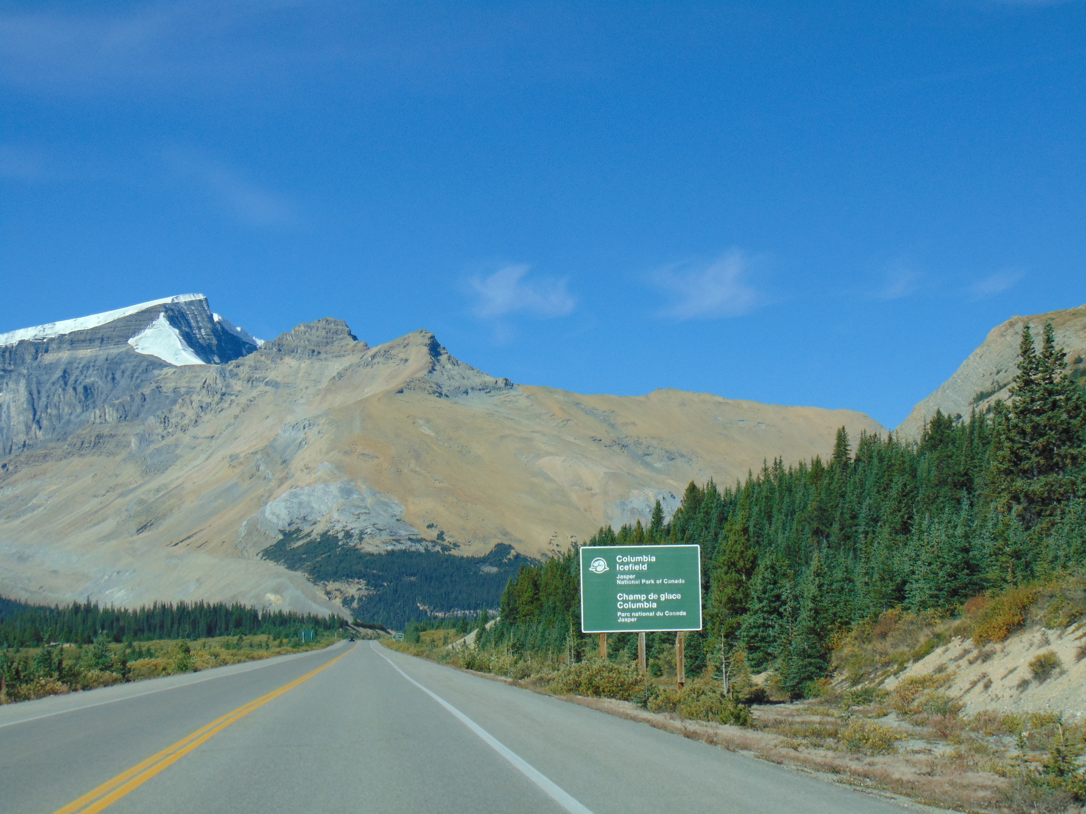
| Approaching the Columbia Icefield visitor's center, which means it's time for the next stop. |
At 128 kilometers up the Icefields Parkway, we've reached the Athabasca Glacier, which is a toe of the glacier that is part of the much larger Columbia Icefield. The Columbia Icefield is the largest in the Canadian Rockies, covering about 230 square kilometers (89 square miles) at depths up to 265 meters (1,200 feet) thick. The Columbia Icefield forms a high-altitude ice cap that sits atop a plateau and covers several mountains that sit along the Continental Divide, including Mount Athabasca, and Snow Dome. Snow Dome, where water from its peak flows to the Pacific, Atlantic, or Arctic Ocean.
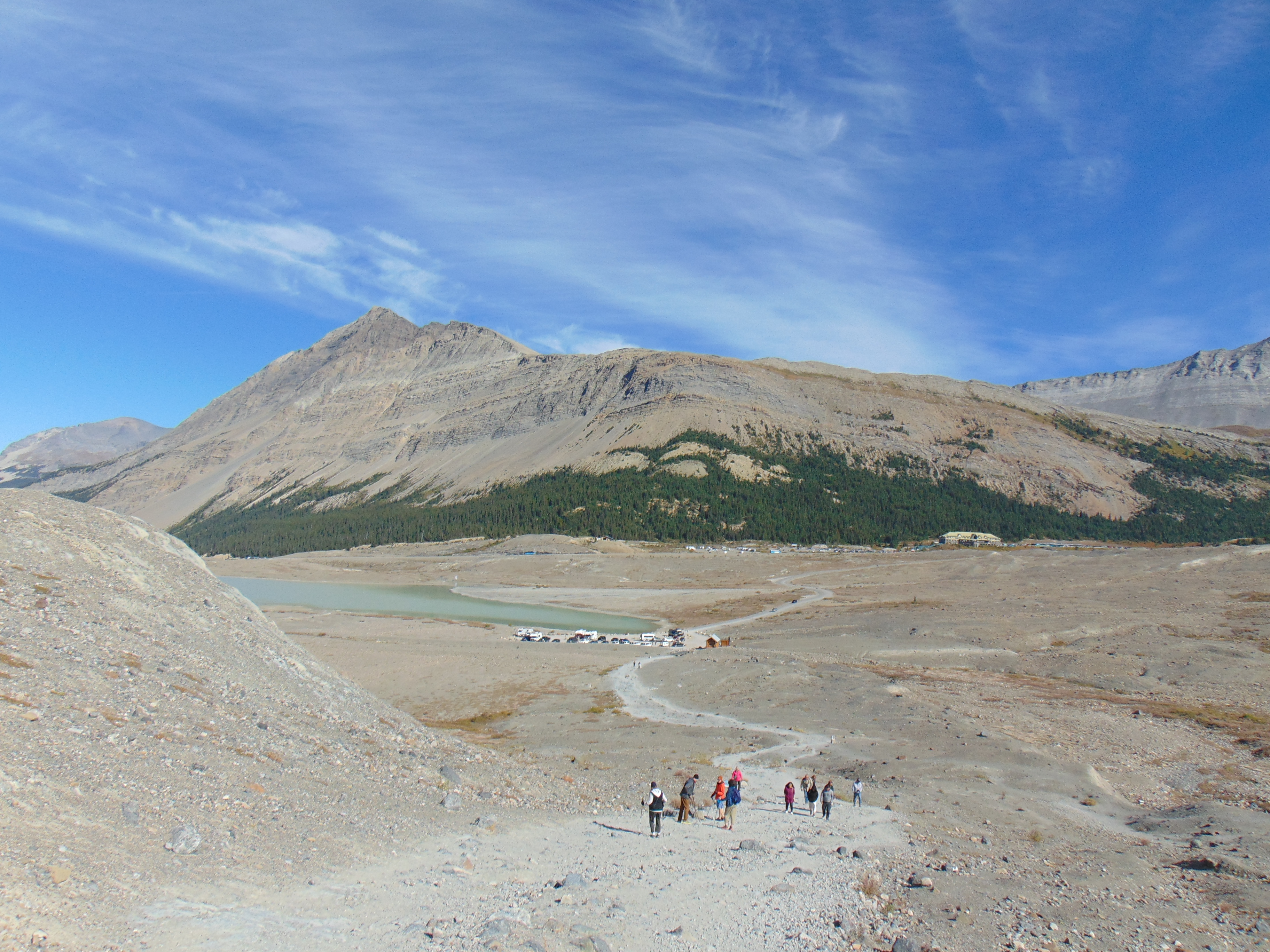
But it's the Athabasca Glacier that is quite accessible from the Icefields Parkway, and it is quite possibly the most accessible glacier in the world. While some people choose to venture onto the glacier by way of a guided tour utilizing a specialized shuttle that goes on the glacier or experience the Columbia Icefield Skywalk, others prefer taking a hike to the toe of the Athabasca Glacier. I decided to hike the Toe of the Glacier Trail, which gets very close to the glacier, but not quite to the point where you can touch ice. This out-and-back trail is 0.9 miles or 1.4 kilometers long to the toe of the Athabasca Glacier. The view is amazing, but concerning as well, considering the glacier has receded more than a mile (1.6 kilometers) and lost half of its volume in the past 125 years.
 |
| From the Toe of the Glacier Trail, you can see several vantage points of the Columbia Icefield and a few different glaciers, not just the Athabasca Glacier. |
 |
| It's all very impressive to look at and take in. |
 |
| There's Mount Andromeda, and the Athabasca Glacier to the right. |
 |
| Along the hiking trail, there are markers for where the Athabasca Glacier ended at different years, so you can get a glimpse of how far back the ice has receded. This is where the toe of the glacier ended in 1982, and as you can see, there's still an uphill trek to see where the glacier was in September 2024. The Mendenhall Glacier in Juneau, Alaska has a similar trail showing where the border of the ice was at different years. |
 |
| Looking behind me back to the trailhead. That's Sunwapta Lake near the trailhead and Wilcox Peak in the distance. |
 |
| Mount Andromeda. The dust clouds you might see in the photo are from the shuttles traveling to and from the glacier. |
 |
| A moment in time: This is what the Athabasca Glacier looked like on September 17, 2024, at around noon. |
 |
| The Toe of the Glacier Trail takes you as far as where the edge of the ice was in 2006. While it was a perfect September day, there was a chill that came off the ice. |
 |
| Mount Andromeda. |
 |
| Mount Andromeda again, along with the silt, dirt, stones, and other debris left behind by the receding glacier. |
 |
| A stream fed by the glacier that eventually makes its way to Sunwapta Lake. |
 |
| There is a pond in between, and you can see some plant life growing in places where there was a glacier not long ago. |
 |
| One final look at Athabasca Glacier. |
 |
| You can also see Snow Dome, and I believe Mount Kitchener, from the trail as well. |
 |
| Plus there's a definitive view of how the Columbia Icefield sits on top of the mountain like a hat. |
At this point, it's back to the Icefields Parkway heading north. The next stretch of highway takes you alongside scenic mountains and the Sunwapta River. Tangle Ridge, Stutfield Glacier, and a few waterfalls are also worthwhile points of interest along the way. Also, the surroundings seem to become more enchanting as well.
 |
| 100 kilometers to the Jasper townsite. Mind you, we're already within the boundaries of Jasper National Park. |
 |
| I believe that's Mount Cromwell in the background. |
 |
| At 159 feet (48 meters) in height, Tangle Falls is a roadside waterfall along the Icefields Parkway. This waterfall has a few nice drops and makes for a nice quick stop. |
 |
| Because it's back on the road. Mounts Cromwell and Englehard are straight ahead. |
 |
| Stutfield Glacier, which is also part of the Columbia Icefield. |
 |
| Mushroom Peak, I believe. Mountains are neither fungi nor delicious but are quite scenic. There's also the Diadem Peak in the mix. |
 |
| I really like the various sweeping curves of the Icefield Parkway. |
 |
| The mountain in view is part of the Endless Chain Ridge, which is a 16-kilometer (10-mile) long mountain ridge, averaging 2867 meters in elevation and rising a kilometer or more above the east side of the Icefields Parkway. |
 |
| Another angle of the Waterfall Peaks, part of the Endless Chain Ridge. |
 |
| I swear, some of these mountain scenes are pretty close to a painting. |
 |
| More of the Waterfall Peaks on such a bluebird day. |
 |
| Living up to the name of the Canadian Rockies. |
 |
| The Catacombs and Dragon Peak up yonder. |
 |
| That bird on the road is pretty huge, despite it looking like a speck on film. |
 |
| Behind Catacombs Mountain, you have Brussels Mountain. |
 |
| Enough mountain talk, let's go chase waterfalls, despite TLC's pleas to do the contrary. |
At 55 feet (17 meters) tall,
Sunwapta Falls is one of the most visited waterfalls in Jasper National Park and along the Icefields Parkway. Along the Sunwapta River, there's an upper Sunwapta Falls, which is the waterfall more commonly known as Sunwapta Falls and is a short walk from the parking lot, but a longer hike will take you down the gorge to the lower Sunwapta Falls. I spent some time checking out the different tiers of the impressive upper waterfall but passed on hiking to the lower waterfall in the interest of time. Sunwapta Falls is located at kilometer 177 of the Icefields Parkway.
 |
| There was some damage along the path to Sunwapta Falls from the devastating Jasper wildfires that took place in July and August 2024, and if you were coming up the Icefields Parkway from Lake Louise as I had done, this may be the first glimpse you see of the destruction from the wildfires. Access to Sunwapta Falls was temporarily closed due to trying to contain and put out the fires, and I believe it only reopened within a week of my trip down the Icefields Parkway. |
 |
| Sunwapta Falls in all of her glory. The water that cascades down Sunwapta Falls and the Sunwapta River is fed by the Athabasca Glacier upstream. |
 |
| An island of trees sits in the middle of the Sunwapta River just before the waterfall. |
 |
| A footbridge crosses the gorge just downstream of Sunwapta Falls. You can view the waterfall from the footbridge as well. |
 |
| The churning water at Sunwapta Falls looks dreamy. |
 |
| A parting shot of Sunwapta Falls. That's Shackle Peak in the background. |
Back on the Icefields Parkway, the sweeping views of the surrounding mountains continue. But a new guest star arrives on the scene, which is the
Athabasca River. With its source at Athabasca Glacier, the
Athabasca River is Alberta's longest river, and 168 kilometers of the river run through Jasper National Park. The Athabasca River travels about 1,500 kilometers northeast through Alberta to Lake Athabasca, then flows into the Slave River, McKenzie River, and finally to the Arctic Ocean.
The Athabasca River's humble beginnings here in the Canadian Rockies have long been the traditional meeting, hunting, and fishing grounds for a number of First Nations tribes. Also, it was part of a fur trading route between the McKenzie River in the Northwest Territories to the Great Lakes region. But today, the Icefields Parkway is the ribbon of pavement that chauffeurs the Athabasca River from the glaciers to the Yellowhead Highway at the Jasper townsite.
 |
| Mount Fryatt to the left, Mount Kerkeslin to the right in the background. |
 |
| The beautiful Athabasca River runs very close to the Icefields Parkway for a few kilometers. |
 |
| More Mount Fryatt, with Geraldine Peak and Mount Edith Cavell behind it. Being pretty far north, there are also a few vestiges of the autumn starting to pop up in the form of fall foliage. It was a perfect day in the middle of September after all, and just days before the autumnal equinox. |
 |
| Geraldine Peak, Mount Edith Cavell, the Athabasca River, and forests as far as the eye can see. Mount Edith Cavell is named for a British nurse by the name of Edith Cavell who helped treat patients during World War I. At the time the war broke out in 1914, she was working at a hospital in Brussels, helping to pioneer the nursing profession in Belgium. Over eleven months, she treated over 200 soldiers from the United Kingdom, Belgium, and France, and helped smuggle the soldiers to the Netherlands, which was a neutral country at the time. As Belgium was under German control at the time, Cavell was arrested, tried, and sentenced to death for these actions in 1915. |
 |
| I stopped at the Goats and Glaciers Lookout at kilometer 196 of the Icefields Parkway for a bit. |
While my stop at the Goats and Glaciers Lookout was a quick stop, it did give me the chance to stretch my legs and check out the surroundings. It was here where I got to see more damage from the 2024 Jasper wildfires, as a large number of trees were burnt on the east side of the Icefields Parkway and up Mount Kerkeslin. While I did not see any goats, I was able to see a couple of wonderful views of the Athabasca River. At the time of my trip, this was the northernmost turn-off of the Icefields Parkway that had reopened after the wildfires to the public.
 |
| Mount Kerkeslin. |
 |
| I like these signs at Jasper National Park which help point out the name and height of the mountain you're looking at. |
 |
| There are also some great views of the Athabasca River to be seen from the Goats and Glaciers Lookout. |
 |
| Plus the water flowing down the Athabasca River looks like an amazing turquoise color. My understanding is that it is a mix of the glacial silt in the water and the reflection of the sun against the water. |
The final stretch of the Icefields Parkway on the way to the Jasper townsite offers some incredible views of the mountains but is tempered by the remains of wildfires that started just a couple of months before my trip. It is a somber reminder that fire is part of the lifecycle of the forest, and it will take decades of plant growth to restore the forest to maturity. There was also park infrastructure that had been damaged or destroyed by the fire. Campgrounds at Jasper National Park were burned and remained closed for the remainder of the 2024 season. Hiking trails and other attractions now necessitate rebuilding before they can be reopened. In speaking with a friend who visited Jasper National Park a year prior, much of what he checked out while at the park had been destroyed by wildfires. Yet, I was glad to see what I could during my trip up the Icefields Parkway, and I was fortunate enough that crews worked at a breakneck pace to contain the fire, clear debris, and reopen the road and as many points of interest as they could in such a short amount of time.
 |
| Back on the road, you can start to see wildfire damage and burn scars way off in the distance. |
 |
| Heading up to AB 93A, the Wabasso Road. It's an alternative road to Icefields Parkway in this part of Jasper National Park, leading visitors to campgrounds, trailheads, and Athabasca Falls. Access to Athabasca Falls was not reopened to the public at the time of my visit, and the Wabasso Road was barricaded, so I was not able to see that incredible-looking waterfall. |
 |
| Since we're in a national park in Canada, both French and English are used on signs. |
 |
| Only 30 kilometers to Jasper! |
 |
| Now this is where the devastation becomes real, with this view of Mount Hardisty. |
 |
| Antler Mountain peeks out from behind the trees. |
 |
| The view from Athabasca Pass. |
 |
| Wildfires tend to like to jump around, so there are a few pockets of trees that were unscathed. |
 |
| Aquila Mountain and Marmot Basin are up ahead. Marmot Basin is a popular ski area near Jasper. |
 |
| I decided to post a bunch of wildfire-related photos to this article because it helps tell my story of visiting the Icefields Parkway, and because it will help tell the story for those who travel the road after me. But you have to admit, that's one heck of a mountain that we're approaching. |
 |
| With the burn scars, there is hope that new trees will come and grow in its place. But yes, the Jasper wildfires did a number on the surroundings. |
 |
| The other end of AB 93A (Wabasso Road). There are also mountains in the distance, such as Pyramid Mountain. Whistlers Peak, which is where the Jasper SkyTram is located, is out of view here. |
 |
| AB 93 and AB 93A shields were burnt to a crisp. I had noticed elsewhere that the signs that had been damaged or destroyed by fire had mostly either been replaced or a canvas had been put over the sign, but not here. |
 |
| Getting closer to the Jasper townsite, the majestic Pyramid Mountain becomes prominent in view. |
 |
| The Icefields Parkway (and AB 93) ends at Alberta Highway 16 (AB 16, or Trans-Canada Highway 16)) in Jasper. AB 16 is part of the Trans-Canada Highway Network and the Yellowhead Highway that travels from Prince Rupert, British Columbia to Manitoba by way of central Alberta and Saskatchewan. If you were to turn west at this intersection, British Columbia and Mount Robson are only about 30 kilometers away at the Yellowhead Pass. If you go east, the highway goes through even more scenic stretches of Jasper National Park. Instead, I ventured into town to buy a couple of magnets as souvenirs, and then worked my way east towards Edmonton after that, closing my visit to the Icefields Parkway. |
How to Get There:
Sources and Links:
The Odyssey Travel Blog -
Icefields Parkway, Alberta The Faiolas -
A journey through time and beauty in the Icefields ParkwayCoastal Breeze News -
The Icefields ParkwayTransCanadaHighway.com -
Icefields Parkway (Lake Louise-Columbia Icefields-Jasper)


Comments